
Magnitude |
:3.3 |
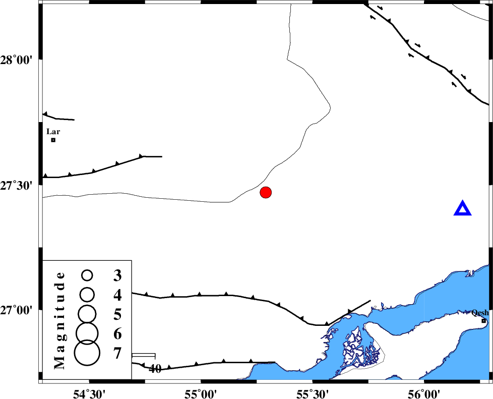
| Date & Time (UTC) | 2007-06-04 18:34:11.2 |
| Date & Time (Local) | 1386/3/14 22:04:11.2 |
| Location | Lat:27.47 Lon: 55.29 |
| Region | 95 km North-East of Bastak, Hormozgan Province |
Nearest Cities |
|
| 46 km South West of Darz, Fars Province | |
| 63 km South West of Fin, Hormozgan Province | |
| 65 km North West of Bandar-e khamir, Hormozgan Province | |
| 82 km South East of Fadami, Fars Province | |
| 93 km South East of Latifi, Fars Province | |
| Depth | 14 km |
| Agency | |
Faults within 150 km: |
|
| MFF1 (Length: 180 km) , Distance to epicenter: 48 km | |
| LAR_F (Length: 99 km) , Distance to epicenter: 48 km | |
| ZFF1 (Length: 165 km) , Distance to epicenter: 76 km | |
| Number of Phases | 4 |
| RMS | 0.2 |
| Number of Stations | 3 |
| Error in Latitude | >8 km |
| Error in Longitude | 2.7 km |
| Error in Depth | 6.6 km |
Download waveform in seisan format
to download seisan software Click here
to access information about IIEES stations Click here
Amplitude | ||||||||
| UID | Agency | Station | Component | Amplitude | Period | Arrival Time | Proccessing Time | Signal Clip |
| 37845 | IIEES | BNDS | N | 1591.1 | 0.32 | 2007-06-04 18:34:43 | 2007-07-30 02:44:00 | n |
| 37846 | IIEES | GHIR | E | 143.6 | 0.52 | 2007-06-04 18:35:28 | 2007-07-30 02:44:00 | n |
| 37847 | IIEES | GHIR | N | 133.4 | 0.56 | 2007-06-04 18:35:36 | 2007-07-30 02:44:00 | n |
Phase | ||||||||||||
| Agency | Station | Component | Phase Type | Phase Quality | First Motion | Observed Arrival Time | Time Residual | Loc. Flag | Input Weight | Distance | Azimuth | |
| IIEES | BNDS | Z | Pg | E | 2007-06-04 18:34:26 | -0.1 | y | 88 | 95 | |||
| IIEES | GHIR | Z | Pn | E | 2007-06-04 18:34:49 | 0.2 | y | 244 | 292 | |||
| IIEES | GHIR | E | Sg | E | 2007-06-04 18:35:19 | -0.2 | y | 244 | 292 | |||
| IIEES | KRBR | Z | Pn | E | 2007-06-04 18:34:58 | 0 | y | 313 | 27 | |||