
Magnitude |
:3.7 |
| Date & Time (UTC) | 2007-03-26 07:04:32.7 |
| Date & Time (Local) | 1386/1/6 10:34:32.7 |
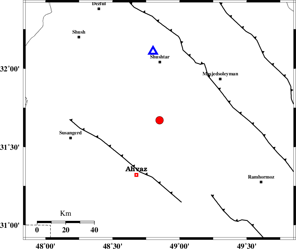
| Location | Lat:31.67 Lon: 48.85 |
| Region | 40 km South of Shushtar, Khoozestan Province |
Nearest Cities |
|
| 10 km North of Mollasani, Khoozestan Province | |
| 11 km North of Talieh, Khoozestan Province | |
| 18 km South of Arabhasan, Khoozestan Province | |
| 21 km North of Veys, Khoozestan Province | |
| 31 km South of Mehdiabad, Khoozestan Province | |
| Depth | 8 km |
| Agency | |
Faults within 150 km: |
|
| AHVAZ_F (Length: 99 km) , Distance to epicenter: 37 km | |
| DEZFUL_EMBAYMENT (Length: 228 km) , Distance to epicenter: 46 km | |
| AGHAJARI_F (Length: 88 km) , Distance to epicenter: 64 km | |
| Number of Phases | 6 |
| RMS | 0.4 |
| Number of Stations | 5 |
| Error in Latitude | >6.8 km |
| Error in Longitude | 13.2 km |
| Error in Depth | 0 km |
Download waveform in seisan format
to download seisan software Click here
to access information about IIEES stations Click here
Amplitude | ||||||||
| UID | Agency | Station | Component | Amplitude | Period | Arrival Time | Proccessing Time | Signal Clip |
| 37664 | IIEES | ASAO | E | 229.2 | 0.6 | 2007-03-26 07:06:14 | 2007-04-22 03:28:00 | n |
| 37665 | IIEES | ASAO | N | 275.7 | 0.73 | 2007-03-26 07:06:19 | 2007-04-22 03:28:00 | n |
| 37666 | IIEES | THKV | N | 46.6 | 0.89 | 2007-03-26 07:07:14 | 2007-04-22 03:28:00 | n |
| 37667 | IIEES | THKV | E | 54.3 | 0.73 | 2007-03-26 07:07:19 | 2007-04-22 03:28:00 | n |
Phase | ||||||||||||
| Agency | Station | Component | Phase Type | Phase Quality | First Motion | Observed Arrival Time | Time Residual | Loc. Flag | Input Weight | Distance | Azimuth | |
| IIEES | SHGR | Z | Pg | E | 2007-03-26 07:04:41 | 0 | y | 48.3 | 354 | |||
| IIEES | SHGR | N | Sg | E | 2007-03-26 07:04:47 | 0 | y | 48.3 | 354 | |||
| IIEES | ASAO | Z | Pn | E | 2007-03-26 07:05:23 | 0.1 | y | 337 | 19 | |||
| IIEES | GHVR | Z | Pn | E | 2007-03-26 07:05:29 | 0.4 | y | 383 | 35 | |||
| IIEES | SNGE | Z | Pn | E | 2007-03-26 07:05:31 | 0.1 | y | 404 | 340 | |||
| IIEES | THKV | Z | Pn | E | 2007-03-26 07:05:43 | -0.8 | y | 507 | 21 | |||