
Magnitude |
:4.1 |
| Date & Time (UTC) | 2007-03-18 14:19:42.1 |
| Date & Time (Local) | 1385/12/27 17:49:42.1 |
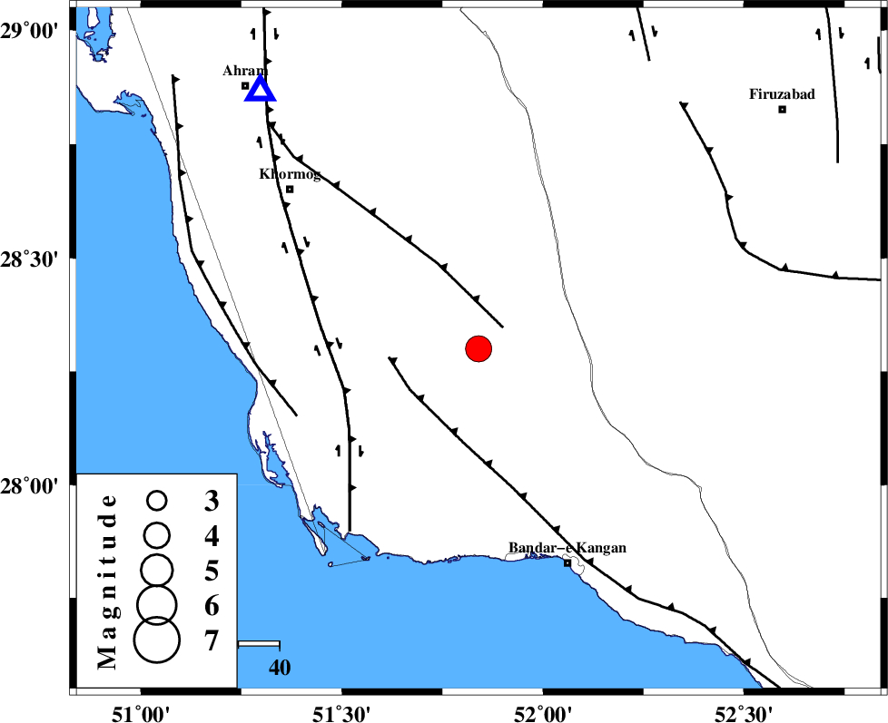
| Location | Lat:28.3 Lon: 51.84 |
| Region | 57 km North-West of Bandar-e kangan, Bushehr Province |
Nearest Cities |
|
| 13 km of Shanbeh, Bushehr Province | |
| 26 km North of Abdan, Bushehr Province | |
| 32 km East of Kaki, Bushehr Province | |
| 34 km North East of Abkesh, Bushehr Province | |
| 35 km East of Baduleh, Bushehr Province | |
| Depth | 15 km |
| Agency | |
Faults within 150 km: |
|
| MFF5 (Length: 74 km) , Distance to epicenter: 8 km | |
| MFF3 (Length: 292 km) , Distance to epicenter: 20 km | |
| BORAZJAN_F (Length: 168 km) , Distance to epicenter: 34 km | |
| Number of Phases | 5 |
| RMS | 0 |
| Number of Stations | 5 |
| Error in Latitude | >10 km |
| Error in Longitude | 1.7 km |
| Error in Depth | 0 km |
Download waveform in seisan format
to download seisan software Click here
to access information about IIEES stations Click here
Amplitude | ||||||||
| UID | Agency | Station | Component | Amplitude | Period | Arrival Time | Proccessing Time | Signal Clip |
| 37610 | IIEES | KRBR | N | 201.4 | 0.72 | 2007-03-18 14:21:54 | 2007-04-22 03:28:00 | n |
| 37611 | IIEES | ASAO | N | 43.1 | 0.64 | 2007-03-18 14:22:38 | 2007-04-22 03:28:00 | n |
| 37612 | IIEES | ASAO | E | 38.6 | 0.6 | 2007-03-18 14:22:41 | 2007-04-22 03:28:00 | n |
Phase | ||||||||||||
| Agency | Station | Component | Phase Type | Phase Quality | First Motion | Observed Arrival Time | Time Residual | Loc. Flag | Input Weight | Distance | Azimuth | |
| IIEES | NASN | Z | P | E | 2007-03-18 14:20:52 | 0 | y | 507 | 10 | |||
| IIEES | KRBR | Z | Pn | E | 2007-03-18 14:20:53 | 0 | y | 514 | 68 | |||
| IIEES | ASAO | Z | Pn | E | 2007-03-18 14:21:18 | 0.1 | y | 714 | 347 | |||
| IIEES | DAMV | Z | Pn | E | 2007-03-18 14:21:30 | 0 | y | 813 | 1 | |||
| IIEES | SNGE | Z | P | E | 2007-03-18 14:21:37 | -0.1 | y | 865 | 332 | |||