
Magnitude |
:2.6 |
| Date & Time (UTC) | 2007-01-06 16:46:06.9 |
| Date & Time (Local) | 1385/10/16 20:16:06.9 |
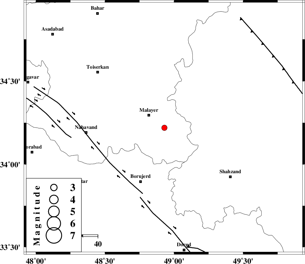
| Location | Lat:34.22 Lon: 48.93 |
| Region | 13 km East of Malayer, Hamedan Province |
Nearest Cities |
|
| 5 km of Jozan, Hamedan Province | |
| 6 km of Jurab, Hamedan Province | |
| 11 km of Aznav, Hamedan Province | |
| 13 km East of Malayer, Hamedan Province | |
| 14 km North West of Zangeh olia, Hamedan Province | |
| Depth | 18 km |
| Agency | |
Faults within 150 km: |
|
| NAHAVAND_F (Length: 102 km) , Distance to epicenter: 43 km | |
| DORUD (Length: 100 km) , Distance to epicenter: 49 km | |
| SAHANEH_F (Length: 77 km) , Distance to epicenter: 62 km | |
| Number of Phases | 6 |
| RMS | 0.1 |
| Number of Stations | 4 |
| Error in Latitude | >7.3 km |
| Error in Longitude | 1.6 km |
| Error in Depth | 3.5 km |
Download waveform in seisan format
to download seisan software Click here
to access information about IIEES stations Click here
Amplitude | ||||||||
| UID | Agency | Station | Component | Amplitude | Period | Arrival Time | Proccessing Time | Signal Clip |
| 37227 | IIEES | ASAO | N | 177.6 | 0.32 | 2007-01-06 16:46:39 | 2007-05-09 05:26:00 | n |
| 37228 | IIEES | ASAO | E | 164.6 | 0.28 | 2007-01-06 16:46:39 | 2007-05-09 05:26:00 | n |
| 37229 | IIEES | SNGE | N | 52.5 | 0.2 | 2007-01-06 16:46:58 | 2007-05-09 05:26:00 | n |
Phase | ||||||||||||
| Agency | Station | Component | Phase Type | Phase Quality | First Motion | Observed Arrival Time | Time Residual | Loc. Flag | Input Weight | Distance | Azimuth | |
| IIEES | ASAO | Z | Pg | E | 2007-01-06 16:46:25 | 0.1 | y | 107 | 70 | |||
| IIEES | ASAO | E | Sg | E | 2007-01-06 16:46:38 | -0.1 | y | 107 | 70 | |||
| IIEES | SNGE | Z | Pg | E | 2007-01-06 16:46:35 | -0.1 | y | 174 | 304 | |||
| IIEES | SNGE | N | Sg | E | 2007-01-06 16:46:56 | 0 | y | 174 | 304 | |||
| IIEES | CHTH | Z | Pn | E | 2007-01-06 16:46:48 | 0.1 | y | 274 | 46 | |||
| IIEES | DAMV | Z | Pn | E | 2007-01-06 16:46:53 | -0.1 | y | 319 | 60 | |||