
Magnitude |
:3 |
| Date & Time (UTC) | 2006-11-16 21:06:11.1 |
| Date & Time (Local) | 1385/8/26 00:36:11.1 |
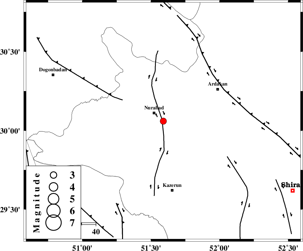
| Location | Lat:30.06 Lon: 51.59 |
| Region | 8 km Nurabad, Fars Province |
Nearest Cities |
|
| 6 km of Gachgaran, Fars Province | |
| 9 km of Nurabad, Fars Province | |
| 17 km East of Ahangari, Fars Province | |
| 19 km South East of Fahlian-e olia, Fars Province | |
| 22 km South of Masiri, Fars Province | |
| Depth | 18 km |
| Agency | |
Faults within 150 km: |
|
| KAZERUN_F (Length: 96 km) , Distance to epicenter: 2 km | |
| MISHAN_F (Length: 76 km) , Distance to epicenter: 32 km | |
| HZF3 (Length: 197 km) , Distance to epicenter: 48 km | |
| Number of Phases | 6 |
| RMS | 0.1 |
| Number of Stations | 4 |
| Error in Latitude | >1.2 km |
| Error in Longitude | 4.8 km |
| Error in Depth | 6.7 km |
Download waveform in seisan format
to download seisan software Click here
to access information about IIEES stations Click here
Amplitude | ||||||||
| UID | Agency | Station | Component | Amplitude | Period | Arrival Time | Proccessing Time | Signal Clip |
| 36707 | IIEES | GHIR | N | 129 | 0.6 | 2006-11-16 21:07:34 | 2007-01-07 07:24:00 | n |
| 36708 | IIEES | GHIR | E | 146.8 | 0.64 | 2006-11-16 21:07:41 | 2007-01-07 07:24:00 | n |
| 36709 | IIEES | ASAO | E | 9 | 0.64 | 2006-11-16 21:08:22 | 2007-01-07 07:24:00 | n |
| 36710 | IIEES | ASAO | N | 8.5 | 0.56 | 2006-11-16 21:08:23 | 2007-01-07 07:24:00 | n |
Phase | ||||||||||||
| Agency | Station | Component | Phase Type | Phase Quality | First Motion | Observed Arrival Time | Time Residual | Loc. Flag | Input Weight | Distance | Azimuth | |
| IIEES | GHIR | Z | Pg | E | 2006-11-16 21:06:50 | 0 | y | 239 | 145 | |||
| IIEES | GHIR | E | Sg | E | 2006-11-16 21:07:18 | 0 | y | 239 | 145 | |||
| IIEES | NASN | Z | Pn | E | 2006-11-16 21:06:59 | 0 | y | 325 | 21 | |||
| IIEES | NASN | E | Sg | E | 2006-11-16 21:07:42 | 0 | y | 325 | 21 | |||
| IIEES | SHGR | Z | Pn | E | 2006-11-16 21:07:01 | 0.2 | y | 350 | 311 | |||
| IIEES | ASAO | Z | Pn | E | 2006-11-16 21:07:22 | -0.2 | y | 519 | 344 | |||