
Magnitude |
:3 |
| Date & Time (UTC) | 2006-09-25 04:48:34.8 |
| Date & Time (Local) | 1385/7/3 08:18:34.8 |
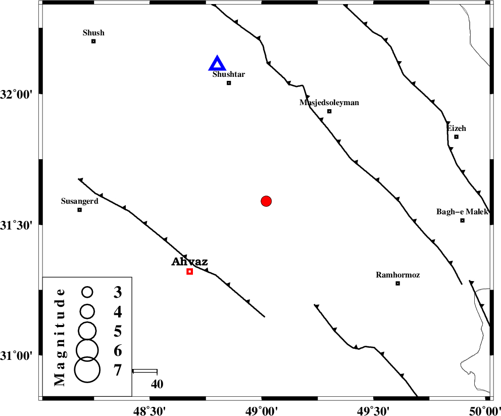
| Location | Lat:31.59 Lon: 49.02 |
| Region | 44 km North-East of Ahvaz, Khoozestan Province |
Nearest Cities |
|
| 8 km of Talieh, Khoozestan Province | |
| 13 km North East of Mollasani, Khoozestan Province | |
| 18 km North East of Veys, Khoozestan Province | |
| 29 km South East of Arabhasan, Khoozestan Province | |
| 34 km North West of Gazin, Khoozestan Province | |
| Depth | 14 km |
| Agency | |
Faults within 150 km: |
|
| AHVAZ_F (Length: 99 km) , Distance to epicenter: 38 km | |
| DEZFUL_EMBAYMENT (Length: 228 km) , Distance to epicenter: 40 km | |
| AGHAJARI_F (Length: 88 km) , Distance to epicenter: 48 km | |
| Number of Phases | 5 |
| RMS | 0.2 |
| Number of Stations | 4 |
| Error in Latitude | >7.7 km |
| Error in Longitude | 6.4 km |
| Error in Depth | 11.3 km |
Download waveform in seisan format
to download seisan software Click here
to access information about IIEES stations Click here
Amplitude | ||||||||
| UID | Agency | Station | Component | Amplitude | Period | Arrival Time | Proccessing Time | Signal Clip |
| 36052 | IIEES | ASAO | N | 43.1 | 0.61 | 2006-09-25 04:50:22 | 2006-10-17 03:59:00 | n |
| 36053 | IIEES | ASAO | E | 54.2 | 0.54 | 2006-09-25 04:50:23 | 2006-10-17 03:59:00 | n |
| 36054 | IIEES | SNGE | N | 15 | 0.78 | 2006-09-25 04:50:49 | 2006-10-17 03:59:00 | n |
Phase | ||||||||||||
| Agency | Station | Component | Phase Type | Phase Quality | First Motion | Observed Arrival Time | Time Residual | Loc. Flag | Input Weight | Distance | Azimuth | |
| IIEES | SHGR | Z | PG | E | 2006-09-25 04:48:45 | -0.1 | y | 60.9 | 340 | |||
| IIEES | ASAO | Z | PN | E | 2006-09-25 04:49:25 | 0.4 | y | 341 | 16 | |||
| IIEES | ASAO | N | SG | E | 2006-09-25 04:50:10 | -0.1 | y | 341 | 16 | |||
| IIEES | NASN | Z | Pn | E | 2006-09-25 04:49:29 | -0.2 | y | 382 | 68 | |||
| IIEES | SNGE | Z | PN | E | 2006-09-25 04:49:34 | -0.1 | y | 418 | 339 | |||