
Magnitude |
:2.5 |
| Date & Time (UTC) | 2006-08-17 06:05:29.4 |
| Date & Time (Local) | 1385/5/26 09:35:29.4 |
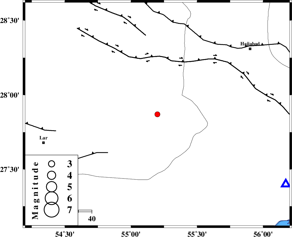
| Location | Lat:27.87 Lon: 55.2 |
| Region | 84 km South-West of Hajiabad, Hormozgan Province |
Nearest Cities |
|
| 22 km North West of Darz, Fars Province | |
| 37 km South of Fadami, Fars Province | |
| 49 km South of Doborji, Fars Province | |
| 65 km South East of Rostaq, Fars Province | |
| 74 km North West of Fin, Hormozgan Province | |
| Depth | 14 km |
| Agency | |
Faults within 150 km: |
|
| HZF2 (Length: 437 km) , Distance to epicenter: 41 km | |
| LAR_F (Length: 99 km) , Distance to epicenter: 47 km | |
| HZF1 (Length: 102 km) , Distance to epicenter: 60 km | |
| Number of Phases | 5 |
| RMS | 0 |
| Number of Stations | 3 |
| Error in Latitude | >1.6 km |
| Error in Longitude | 1.1 km |
| Error in Depth | 4.1 km |
Download waveform in seisan format
to download seisan software Click here
to access information about IIEES stations Click here
Amplitude | ||||||||
| UID | Agency | Station | Component | Amplitude | Period | Arrival Time | Proccessing Time | Signal Clip |
| 35774 | IIEES | BNDS | N | 126.1 | 0.15 | 2006-08-17 06:06:10 | 2006-10-17 03:59:00 | n |
| 35775 | IIEES | GHIR | N | 27.5 | 0.36 | 2006-08-17 06:06:42 | 2006-10-17 03:59:00 | n |
| 35776 | IIEES | GHIR | E | 56.1 | 0.45 | 2006-08-17 06:06:45 | 2006-10-17 03:59:00 | n |
Phase | ||||||||||||
| Agency | Station | Component | Phase Type | Phase Quality | First Motion | Observed Arrival Time | Time Residual | Loc. Flag | Input Weight | Distance | Azimuth | |
| IIEES | BNDS | Z | PG | E | 2006-08-17 06:05:47 | 0 | y | 109 | 118 | |||
| IIEES | GHIR | Z | PG | E | 2006-08-17 06:06:05 | 0 | y | 223 | 282 | |||
| IIEES | GHIR | N | SG | E | 2006-08-17 06:06:32 | 0 | y | 223 | 282 | |||
| IIEES | KRBR | Z | PN | E | 2006-08-17 06:06:12 | 0.1 | y | 279 | 33 | |||
| IIEES | KRBR | N | SG | E | 2006-08-17 06:06:48 | 0 | y | 279 | 33 | |||