
Magnitude |
:2.7 |
| Date & Time (UTC) | 2006-09-16 22:42:44.6 |
| Date & Time (Local) | 1385/6/26 02:12:44.6 |
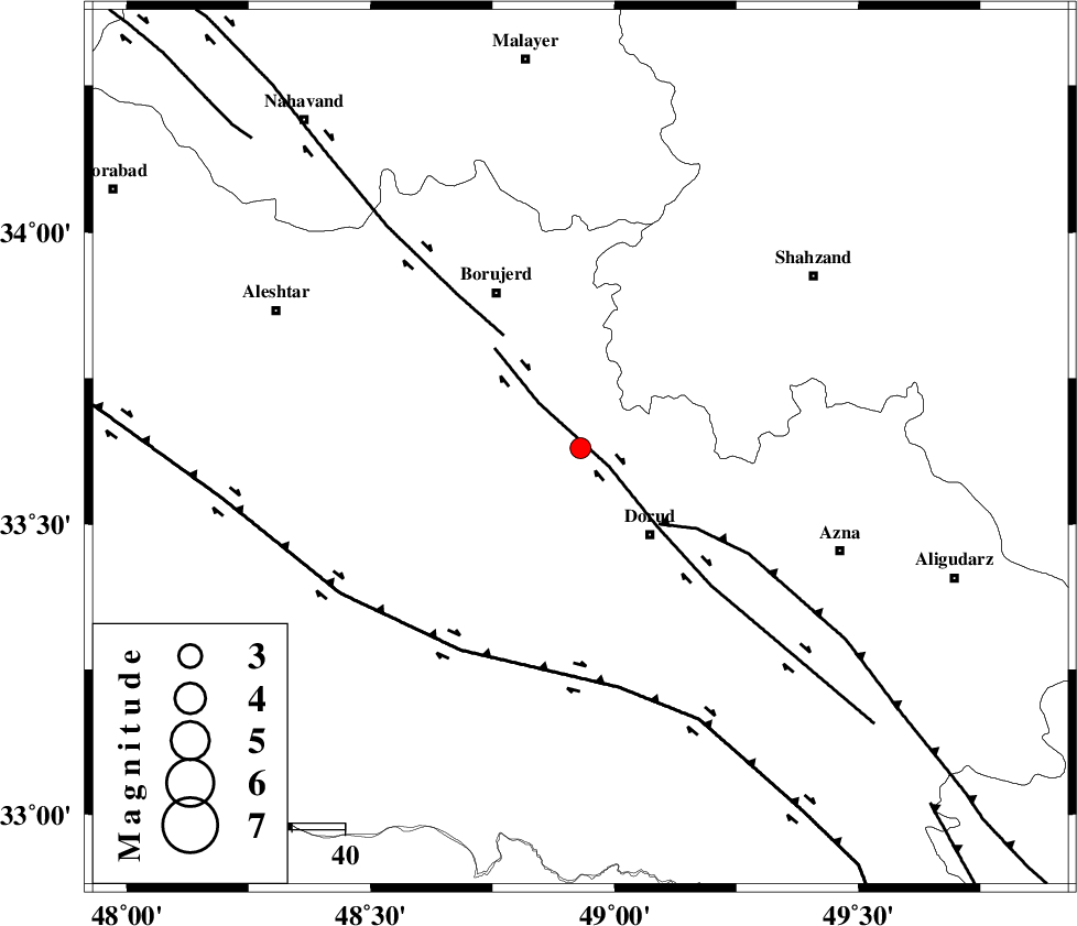
| Location | Lat:33.63 Lon: 48.93 |
| Region | 21 km North-West of Dorud, Lorestan Province |
Nearest Cities |
|
| 3 km North of Kagheh, Lorestan Province | |
| 5 km of Chalanchulan, Lorestan Province | |
| 9 km North of Razan, Lorestan Province | |
| 13 km North of Void, Lorestan Province | |
| 21 km North West of Zhan, Lorestan Province | |
| Depth | 14 km |
| Agency | |
Faults within 150 km: |
|
| DORUD (Length: 100 km) , Distance to epicenter: 2 km | |
| MAIN_ZAGROS_R_F (Length: 1106 km) , Distance to epicenter: 21 km | |
| NAHAVAND_F (Length: 102 km) , Distance to epicenter: 26 km | |
| Number of Phases | 5 |
| RMS | 0.1 |
| Number of Stations | 4 |
| Error in Latitude | >1.7 km |
| Error in Longitude | 2.5 km |
| Error in Depth | 5 km |
Download waveform in seisan format
to download seisan software Click here
to access information about IIEES stations Click here
Amplitude | ||||||||
| UID | Agency | Station | Component | Amplitude | Period | Arrival Time | Proccessing Time | Signal Clip |
| 35766 | IIEES | ASAO | E | 116.6 | 0.68 | 2006-09-16 22:43:30 | 2006-10-17 03:59:00 | n |
| 35767 | IIEES | ASAO | N | 125.4 | 0.49 | 2006-09-16 22:43:30 | 2006-10-17 03:59:00 | n |
| 35768 | IIEES | SHGR | E | 143.7 | 0.45 | 2006-09-16 22:43:42 | 2006-10-17 03:59:00 | n |
| 35769 | IIEES | SNGE | N | 50.1 | 0.67 | 2006-09-16 22:43:52 | 2006-10-17 03:59:00 | n |
Phase | ||||||||||||
| Agency | Station | Component | Phase Type | Phase Quality | First Motion | Observed Arrival Time | Time Residual | Loc. Flag | Input Weight | Distance | Azimuth | |
| IIEES | ASAO | Z | Pg | E | 2006-09-16 22:43:08 | 0 | y | 143 | 45 | |||
| IIEES | ASAO | N | SG | E | 2006-09-16 22:43:25 | -0.1 | y | 143 | 45 | |||
| IIEES | SHGR | Z | PG | E | 2006-09-16 22:43:12 | 0 | y | 170 | 184 | |||
| IIEES | SNGE | Z | PG | E | 2006-09-16 22:43:20 | 0 | y | 218 | 318 | |||
| IIEES | CHTH | Z | Pn | E | 2006-09-16 22:43:32 | 0.2 | y | 322 | 38 | |||