
Magnitude |
:2.5 |
| Date & Time (UTC) | 2006-09-16 22:20:29.2 |
| Date & Time (Local) | 1385/6/26 01:50:29.2 |
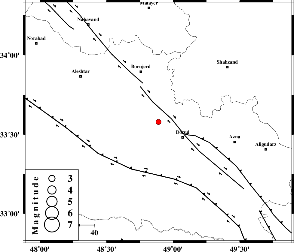
| Location | Lat:33.58 Lon: 48.89 |
| Region | 20 km West of Dorud, Lorestan Province |
Nearest Cities |
|
| 2 km North of Razan, Lorestan Province | |
| 7 km of Kagheh, Lorestan Province | |
| 9 km of Chalanchulan, Lorestan Province | |
| 10 km North of Void, Lorestan Province | |
| 20 km North East of Zagheh, Lorestan Province | |
| Depth | 15 km |
| Agency | |
Faults within 150 km: |
|
| DORUD (Length: 100 km) , Distance to epicenter: 8 km | |
| MAIN_ZAGROS_R_F (Length: 1106 km) , Distance to epicenter: 21 km | |
| NAHAVAND_F (Length: 102 km) , Distance to epicenter: 29 km | |
| Number of Phases | 3 |
| RMS | 0 |
| Number of Stations | 3 |
| Error in Latitude | >1.3 km |
| Error in Longitude | 2.4 km |
| Error in Depth | 0 km |
Download waveform in seisan format
to download seisan software Click here
to access information about IIEES stations Click here
Amplitude | ||||||||
| UID | Agency | Station | Component | Amplitude | Period | Arrival Time | Proccessing Time | Signal Clip |
| 35755 | IIEES | SHGR | E | 89.7 | 0.31 | 2006-09-16 22:21:28 | 2006-10-17 03:59:00 | n |
| 35756 | IIEES | SHGR | N | 61.5 | 0.55 | 2006-09-16 22:21:29 | 2006-10-17 03:59:00 | n |
| 35757 | IIEES | SNGE | N | 26.9 | 0.45 | 2006-09-16 22:21:38 | 2006-10-17 03:59:00 | n |
Phase | ||||||||||||
| Agency | Station | Component | Phase Type | Phase Quality | First Motion | Observed Arrival Time | Time Residual | Loc. Flag | Input Weight | Distance | Azimuth | |
| IIEES | ASAO | Z | Pg | E | 2006-09-16 22:20:54 | 0 | y | 150 | 44 | |||
| IIEES | SHGR | Z | PG | E | 2006-09-16 22:20:56 | 0 | y | 163 | 183 | |||
| IIEES | SNGE | Z | PG | E | 2006-09-16 22:21:05 | 0 | y | 220 | 320 | |||