
Magnitude |
:2.8 |
| Date & Time (UTC) | 2006-09-16 12:02:51.7 |
| Date & Time (Local) | 1385/6/25 15:32:51.7 |
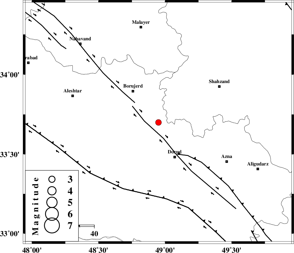
| Location | Lat:33.7 Lon: 48.95 |
| Region | 27 km North-West of Dorud, Lorestan Province |
Nearest Cities |
|
| 7 km North of Chalanchulan, Lorestan Province | |
| 10 km North of Kagheh, Lorestan Province | |
| 14 km West of Hashian, Markazi Province | |
| 16 km North of Razan, Lorestan Province | |
| 20 km North of Void, Lorestan Province | |
| Depth | 15 km |
| Agency | |
Faults within 150 km: |
|
| DORUD (Length: 100 km) , Distance to epicenter: 6 km | |
| NAHAVAND_F (Length: 102 km) , Distance to epicenter: 21 km | |
| MAIN_ZAGROS_R_F (Length: 1106 km) , Distance to epicenter: 26 km | |
| Number of Phases | 5 |
| RMS | 0.3 |
| Number of Stations | 4 |
| Error in Latitude | >3.5 km |
| Error in Longitude | 4.6 km |
| Error in Depth | 9 km |
Download waveform in seisan format
to download seisan software Click here
to access information about IIEES stations Click here
Amplitude | ||||||||
| UID | Agency | Station | Component | Amplitude | Period | Arrival Time | Proccessing Time | Signal Clip |
| 35729 | IIEES | ASAO | E | 161.6 | 0.64 | 2006-09-16 12:03:35 | 2006-10-17 03:59:00 | n |
| 35730 | IIEES | ASAO | N | 158.7 | 1.02 | 2006-09-16 12:03:36 | 2006-10-17 03:59:00 | n |
| 35731 | IIEES | SHGR | E | 181.8 | 0.46 | 2006-09-16 12:03:48 | 2006-10-17 03:59:00 | n |
| 35732 | IIEES | SNGE | N | 88 | 0.53 | 2006-09-16 12:03:57 | 2006-10-17 03:59:00 | n |
Phase | ||||||||||||
| Agency | Station | Component | Phase Type | Phase Quality | First Motion | Observed Arrival Time | Time Residual | Loc. Flag | Input Weight | Distance | Azimuth | |
| IIEES | ASAO | Z | PG | E | 2006-09-16 12:03:14 | -0.5 | y | 137 | 46 | |||
| IIEES | ASAO | N | SG | E | 2006-09-16 12:03:31 | 0.1 | y | 137 | 46 | |||
| IIEES | SHGR | Z | PG | E | 2006-09-16 12:03:20 | -0.1 | y | 177 | 184 | |||
| IIEES | SNGE | Z | PG | E | 2006-09-16 12:03:26 | 0.1 | y | 213 | 317 | |||
| IIEES | NASN | Z | Pn | E | 2006-09-16 12:03:46 | 0.4 | y | 374 | 104 | |||