
Magnitude |
:3.2 |
| Date & Time (UTC) | 2006-08-13 22:12:55.7 |
| Date & Time (Local) | 1385/5/23 01:42:55.7 |
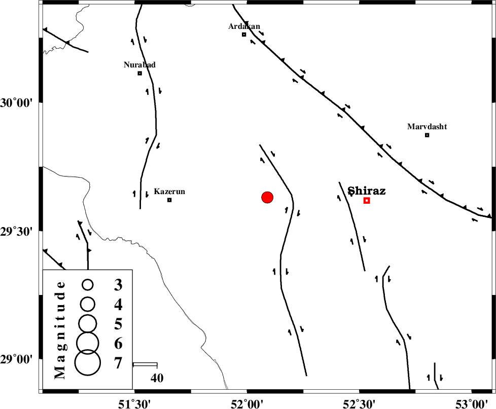
| Location | Lat:29.63 Lon: 52.09 |
| Region | 41 km East of Kazerun, Fars Province |
Nearest Cities |
|
| 14 km West of Khanehzanian, Fars Province | |
| 17 km North of Richi, Fars Province | |
| 22 km North East of Kalani, Fars Province | |
| 41 km North East of Dadin-e olia, Fars Province | |
| 41 km North East of Baladeh, Fars Province | |
| Depth | 14 km |
| Agency | |
Faults within 150 km: |
|
| KAREBASS_F (Length: 98 km) , Distance to epicenter: 10 km | |
| SABZ_PUSHAN_F_Z3 (Length: 37 km) , Distance to epicenter: 32 km | |
| HZF3 (Length: 197 km) , Distance to epicenter: 50 km | |
| Number of Phases | 6 |
| RMS | 0.1 |
| Number of Stations | 5 |
| Error in Latitude | >5.5 km |
| Error in Longitude | 5.3 km |
| Error in Depth | 12.7 km |
Download waveform in seisan format
to download seisan software Click here
to access information about IIEES stations Click here
Amplitude | ||||||||
| UID | Agency | Station | Component | Amplitude | Period | Arrival Time | Proccessing Time | Signal Clip |
| 35621 | IIEES | GHIR | N | 268.6 | 0.55 | 2006-08-13 22:13:54 | 2006-10-17 03:59:00 | n |
| 35622 | IIEES | GHIR | E | 399.6 | 0.73 | 2006-08-13 22:13:57 | 2006-10-17 03:59:00 | n |
| 35623 | IIEES | ASAO | N | 11.4 | 0.52 | 2006-08-13 22:15:21 | 2006-10-17 03:59:00 | n |
| 35624 | IIEES | ASAO | E | 8.6 | 0.67 | 2006-08-13 22:15:24 | 2006-10-17 03:59:00 | n |
Phase | ||||||||||||
| Agency | Station | Component | Phase Type | Phase Quality | First Motion | Observed Arrival Time | Time Residual | Loc. Flag | Input Weight | Distance | Azimuth | |
| IIEES | GHIR | Z | PG | E | 2006-08-13 22:13:24 | -0.1 | y | 173 | 149 | |||
| IIEES | GHIR | E | SG | E | 2006-08-13 22:13:45 | 0 | y | 173 | 149 | |||
| IIEES | NASN | Z | Pn | E | 2006-08-13 22:13:48 | -0.1 | y | 358 | 11 | |||
| IIEES | KRBR | Z | Pn | E | 2006-08-13 22:14:00 | 0.1 | y | 453 | 84 | |||
| IIEES | ASAO | Z | PN | E | 2006-08-13 22:14:15 | 0 | y | 579 | 341 | |||
| IIEES | SNGE | Z | PN | E | 2006-08-13 22:14:37 | 0.1 | y | 752 | 325 | |||