
Magnitude |
:3.9 |
| Date & Time (UTC) | 2006-09-13 16:12:45.3 |
| Date & Time (Local) | 1385/6/22 19:42:45.3 |
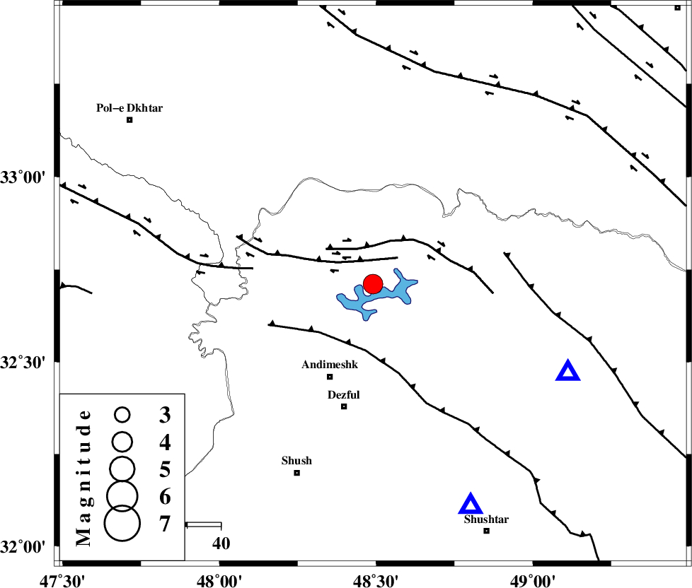
| Location | Lat:32.71 Lon: 48.49 |
| Region | 30 km North-East of Andimeshk, Khoozestan Province |
Nearest Cities |
|
| 17 km East of Sorkhakan, Khoozestan Province | |
| 23 km North East of Hoseinieh, Khoozestan Province | |
| 24 km East of Bidruyeh, Khoozestan Province | |
| 31 km North East of Andimeshk, Khoozestan Province | |
| 31 km West of Shuy, Khoozestan Province | |
| Depth | 14 km |
| Agency | |
Faults within 150 km: |
|
| BALARUD_F_Z3 (Length: 53 km) , Distance to epicenter: 8 km | |
| BALARUD_F_Z2 (Length: 58 km) , Distance to epicenter: 12 km | |
| DEZFUL_EMBAYMENT (Length: 228 km) , Distance to epicenter: 20 km | |
| Number of Phases | 8 |
| RMS | 0.1 |
| Number of Stations | 7 |
| Error in Latitude | >1.4 km |
| Error in Longitude | 3.3 km |
| Error in Depth | 3.6 km |
Download waveform in seisan format
to download seisan software Click here
to access information about IIEES stations Click here
Amplitude | ||||||||
| UID | Agency | Station | Component | Amplitude | Period | Arrival Time | Proccessing Time | Signal Clip |
| 35612 | IIEES | SHGR | N | 5089.9 | 0.78 | 2006-09-13 16:13:26 | 2006-10-17 03:59:00 | n |
| 35613 | IIEES | ASAO | N | 822.9 | 0.68 | 2006-09-13 16:14:01 | 2006-10-17 03:59:00 | n |
| 35614 | IIEES | ASAO | E | 793.2 | 0.68 | 2006-09-13 16:14:04 | 2006-10-17 03:59:00 | n |
| 35615 | IIEES | SNGE | N | 547.2 | 0.93 | 2006-09-13 16:14:15 | 2006-10-17 03:59:00 | n |
Phase | ||||||||||||
| Agency | Station | Component | Phase Type | Phase Quality | First Motion | Observed Arrival Time | Time Residual | Loc. Flag | Input Weight | Distance | Azimuth | |
| IIEES | SHGR | Z | PG | E | 2006-09-13 16:12:57 | 0 | y | 72.3 | 156 | |||
| IIEES | ASAO | Z | PN | E | 2006-09-13 16:13:24 | 0.2 | y | 249 | 34 | |||
| IIEES | ASAO | E | SG | E | 2006-09-13 16:13:55 | 0 | y | 249 | 34 | |||
| IIEES | SNGE | Z | PN | E | 2006-09-13 16:13:28 | 0 | y | 285 | 338 | |||
| IIEES | NASN | Z | Pn | E | 2006-09-13 16:13:43 | 0 | y | 404 | 87 | |||
| IIEES | THKV | Z | Pn | E | 2006-09-13 16:13:45 | 0.1 | y | 418 | 31 | |||
| IIEES | CHTH | Z | PN | E | 2006-09-13 16:13:46 | 0 | y | 430 | 34 | |||
| IIEES | DAMV | Z | PN | E | 2006-09-13 16:13:49 | -0.2 | y | 456 | 44 | |||