
Magnitude |
:3.3 |
| Date & Time (UTC) | 2006-09-10 23:03:19.1 |
| Date & Time (Local) | 1385/6/20 02:33:19.1 |
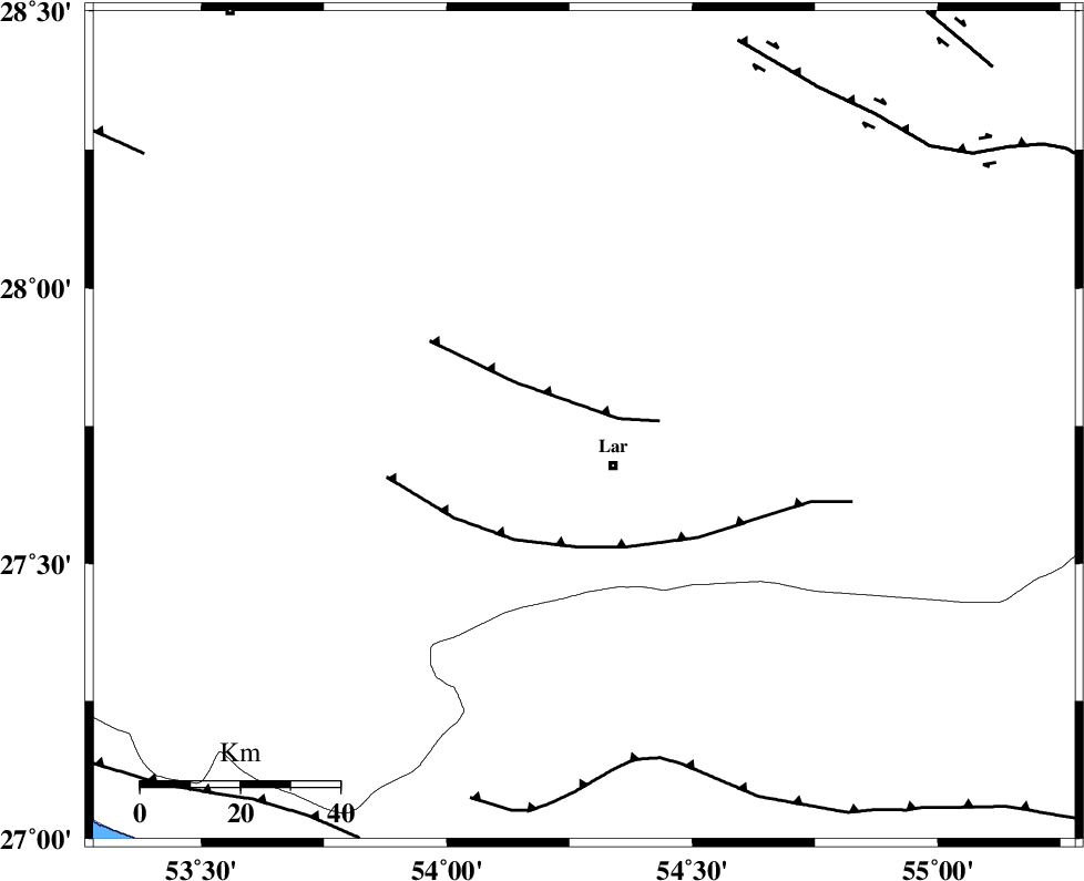
| Location | Lat:27.75 Lon: 54.28 |
| Region | 9 km Lar, Fars Province |
Nearest Cities |
|
| 10 km North of Lar, Fars Province | |
| 11 km North West of Latifi, Fars Province | |
| 16 km North East of Grash, Fars Province | |
| 18 km South West of Dehkuyeh, Fars Province | |
| 27 km East of Avaz, Fars Province | |
| Depth | 17 km |
| Agency | |
Faults within 150 km: |
|
| BERIZ_F (Length: 49 km) , Distance to epicenter: 7 km | |
| LAR_F (Length: 99 km) , Distance to epicenter: 24 km | |
| MFF1 (Length: 180 km) , Distance to epicenter: 68 km | |
| Number of Phases | 5 |
| RMS | 0.3 |
| Number of Stations | 3 |
| Error in Latitude | >6.4 km |
| Error in Longitude | 3.2 km |
| Error in Depth | 12.3 km |
Download waveform in seisan format
to download seisan software Click here
to access information about IIEES stations Click here
Amplitude | ||||||||
| UID | Agency | Station | Component | Amplitude | Period | Arrival Time | Proccessing Time | Signal Clip |
| 35517 | IIEES | GHIR | N | 602 | 0.88 | 2006-09-10 23:04:05 | 2006-10-17 03:59:00 | n |
| 35518 | IIEES | GHIR | E | 898.8 | 0.56 | 2006-09-10 23:04:05 | 2006-10-17 03:59:00 | n |
| 35519 | IIEES | BNDS | N | 295.6 | 0.44 | 2006-09-10 23:04:26 | 2006-10-17 03:59:00 | n |
| 35520 | IIEES | BNDS | E | 198 | 0.44 | 2006-09-10 23:04:27 | 2006-10-17 03:59:00 | n |
| 35521 | IIEES | KRBR | E | 82.3 | 0.56 | 2006-09-10 23:05:01 | 2006-10-17 03:59:00 | n |
| 35522 | IIEES | KRBR | N | 76.2 | 0.68 | 2006-09-10 23:05:07 | 2006-10-17 03:59:00 | n |
Phase | ||||||||||||
| Agency | Station | Component | Phase Type | Phase Quality | First Motion | Observed Arrival Time | Time Residual | Loc. Flag | Input Weight | Distance | Azimuth | |
| IIEES | GHIR | Z | PG | E | 2006-09-10 23:03:42 | -0.5 | y | 141 | 295 | |||
| IIEES | GHIR | E | SG | E | 2006-09-10 23:04:00 | 0.3 | y | 141 | 295 | |||
| IIEES | BNDS | Z | PG | E | 2006-09-10 23:03:50 | 0.1 | y | 190 | 101 | |||
| IIEES | KRBR | Z | PN | E | 2006-09-10 23:04:09 | 0 | y | 346 | 44 | |||
| IIEES | KRBR | N | SG | E | 2006-09-10 23:04:56 | 0 | y | 346 | 44 | |||