
Magnitude |
:3.1 |
| Date & Time (UTC) | 2006-09-10 15:22:45.2 |
| Date & Time (Local) | 1385/6/19 18:52:45.2 |
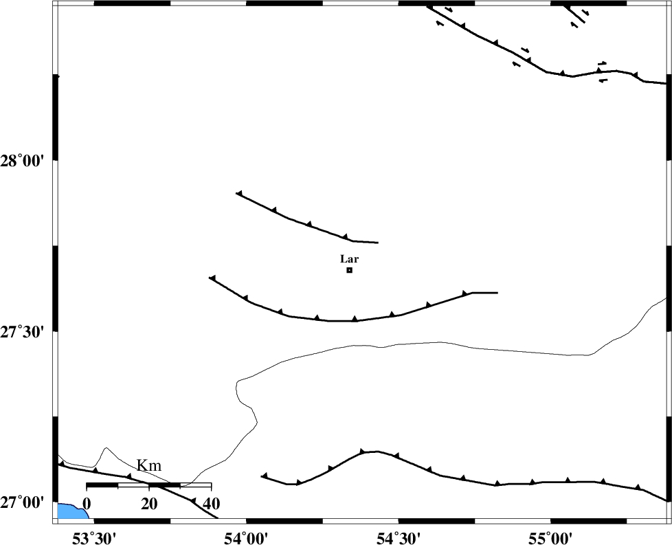
| Location | Lat:27.7 Lon: 54.38 |
| Region | 4 km Lar, Fars Province |
Nearest Cities |
|
| 0 km North of Latifi, Fars Province | |
| 5 km North of Lar, Fars Province | |
| 17 km South of Dehkuyeh, Fars Province | |
| 22 km North East of Grash, Fars Province | |
| 37 km East of Avaz, Fars Province | |
| Depth | 18 km |
| Agency | |
Faults within 150 km: |
|
| BERIZ_F (Length: 49 km) , Distance to epicenter: 8 km | |
| LAR_F (Length: 99 km) , Distance to epicenter: 19 km | |
| MFF1 (Length: 180 km) , Distance to epicenter: 62 km | |
| Number of Phases | 5 |
| RMS | 0.1 |
| Number of Stations | 3 |
| Error in Latitude | >5.3 km |
| Error in Longitude | 2.1 km |
| Error in Depth | 0 km |
Download waveform in seisan format
to download seisan software Click here
to access information about IIEES stations Click here
Amplitude | ||||||||
| UID | Agency | Station | Component | Amplitude | Period | Arrival Time | Proccessing Time | Signal Clip |
| 35497 | IIEES | GHIR | E | 410 | 0.4 | 2006-09-10 15:23:36 | 2006-10-17 03:59:00 | n |
| 35498 | IIEES | GHIR | N | 298.4 | 0.4 | 2006-09-10 15:23:37 | 2006-10-17 03:59:00 | n |
| 35499 | IIEES | KRBR | E | 39.8 | 0.48 | 2006-09-10 15:24:20 | 2006-10-17 03:59:00 | n |
| 35500 | IIEES | KRBR | N | 41.6 | 0.48 | 2006-09-10 15:24:29 | 2006-10-17 03:59:00 | n |
Phase | ||||||||||||
| Agency | Station | Component | Phase Type | Phase Quality | First Motion | Observed Arrival Time | Time Residual | Loc. Flag | Input Weight | Distance | Azimuth | |
| IIEES | GHIR | Z | PG | E | 2006-09-10 15:23:10 | -0.2 | y | 152 | 296 | |||
| IIEES | GHIR | N | SG | E | 2006-09-10 15:23:29 | 0.2 | y | 152 | 296 | |||
| IIEES | BNDS | Z | PG | E | 2006-09-10 15:23:14 | 0 | y | 180 | 100 | |||
| IIEES | BNDS | N | SG | E | 2006-09-10 15:23:36 | 0.1 | y | 180 | 100 | |||
| IIEES | KRBR | Z | PN | E | 2006-09-10 15:23:35 | 0 | y | 343 | 42 | |||