
Magnitude |
:3.2 |
| Date & Time (UTC) | 2006-08-01 00:48:42.2 |
| Date & Time (Local) | 1385/5/10 04:18:42.2 |
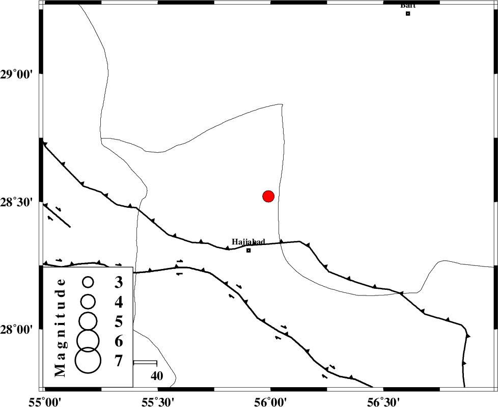
| Location | Lat:28.52 Lon: 55.99 |
| Region | 25 km North of Hajiabad, Hormozgan Province |
Nearest Cities |
|
| 25 km North of Hajiabad, Hormozgan Province | |
| 37 km North West of Arzuieeh, Kerman Province | |
| 39 km North West of Shahmaran, Kerman Province | |
| 61 km North West of Fareqan, Hormozgan Province | |
| 64 km East of Tal bargah, Fars Province | |
| Depth | 15 km |
| Agency | |
Faults within 150 km: |
|
| MAIN_ZAGROS_R_F (Length: 1106 km) , Distance to epicenter: 21 km | |
| HZF2 (Length: 437 km) , Distance to epicenter: 42 km | |
| HZF1 (Length: 102 km) , Distance to epicenter: 87 km | |
| Number of Phases | 6 |
| RMS | 0.3 |
| Number of Stations | 5 |
| Error in Latitude | >2.8 km |
| Error in Longitude | 6.5 km |
| Error in Depth | 8.9 km |
Download waveform in seisan format
to download seisan software Click here
to access information about IIEES stations Click here
Amplitude | ||||||||
| UID | Agency | Station | Component | Amplitude | Period | Arrival Time | Proccessing Time | Signal Clip |
| 35310 | IIEES | BNDS | E | 692.6 | 0.32 | 2006-08-01 00:49:22 | 2006-10-17 03:59:00 | n |
| 35311 | IIEES | KRBR | E | 377.9 | 0.28 | 2006-08-01 00:49:40 | 2006-10-17 03:59:00 | n |
| 35312 | IIEES | KRBR | N | 321.4 | 0.52 | 2006-08-01 00:49:46 | 2006-10-17 03:59:00 | n |
| 35313 | IIEES | GHIR | E | 57.4 | 0.48 | 2006-08-01 00:50:25 | 2006-10-17 03:59:00 | n |
| 35314 | IIEES | GHIR | N | 64.9 | 0.56 | 2006-08-01 00:50:27 | 2006-10-17 03:59:00 | n |
Phase | ||||||||||||
| Agency | Station | Component | Phase Type | Phase Quality | First Motion | Observed Arrival Time | Time Residual | Loc. Flag | Input Weight | Distance | Azimuth | |
| IIEES | BNDS | Z | PG | E | 2006-08-01 00:49:03 | -0.2 | y | 126 | 172 | |||
| IIEES | BNDS | N | SG | E | 2006-08-01 00:49:18 | 0 | y | 126 | 172 | |||
| IIEES | KRBR | Z | PG | E | 2006-08-01 00:49:11 | -0.4 | y | 178 | 25 | |||
| IIEES | GHIR | Z | Pn | E | 2006-08-01 00:49:26 | 0.1 | y | 295 | 266 | |||
| IIEES | ZHSF | Z | Pn | E | 2006-08-01 00:49:50 | 0.5 | y | 481 | 74 | |||
| IIEES | NASN | Z | PN | E | 2006-08-01 00:50:00 | 0.1 | y | 564 | 328 | |||