
Magnitude |
:3.2 |
| Date & Time (UTC) | 2006-06-26 12:51:57.0 |
| Date & Time (Local) | 1385/4/5 16:21:57.0 |
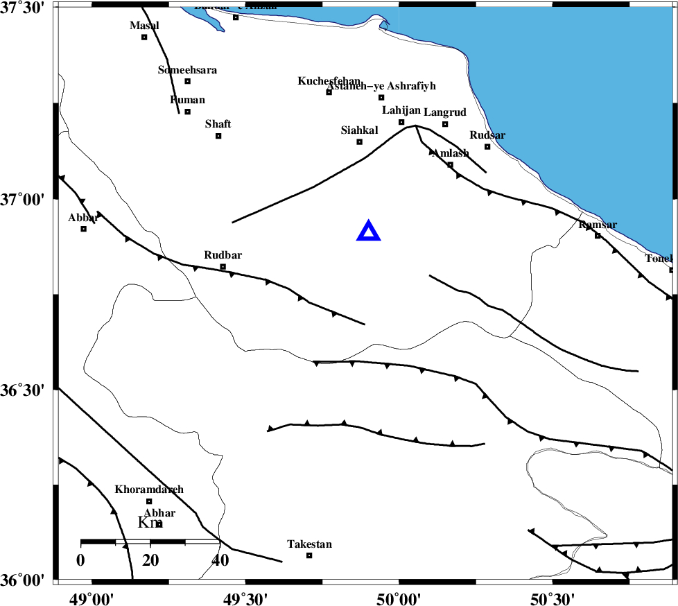
| Location | Lat:36.75 Lon: 49.89 |
| Region | 41 km East of Rudbar, Gilan Province |
Nearest Cities |
|
| 9 km North of Kelishom, Gilan Province | |
| 11 km North East of Jirhandeh, Gilan Province | |
| 12 km South of Barresar, Gilan Province | |
| 23 km South East of Dashtvil, Gilan Province | |
| 32 km South of Khorma, Gilan Province | |
| Depth | 14 km |
| Agency | |
Faults within 150 km: |
|
| RUDBAR_F (Length: 93 km) , Distance to epicenter: 9 km | |
| BONAN_F (Length: 74 km) , Distance to epicenter: 19 km | |
| ALAMUTRUD_F (Length: 140 km) , Distance to epicenter: 20 km | |
| Number of Phases | 9 |
| RMS | 0.3 |
| Number of Stations | 6 |
| Error in Latitude | >4.1 km |
| Error in Longitude | 3.2 km |
| Error in Depth | 8.3 km |
Download waveform in seisan format
to download seisan software Click here
to access information about IIEES stations Click here
Amplitude | ||||||||
| UID | Agency | Station | Component | Amplitude | Period | Arrival Time | Proccessing Time | Signal Clip |
| 35103 | IIEES | CHTH | E | 456.8 | 0.16 | 2006-06-26 12:52:39 | 2008-03-02 12:02:00 | n |
| 35104 | IIEES | GRMI | N | 112.2 | 0.4 | 2006-06-26 12:53:22 | 2008-03-02 12:02:00 | n |
| 35105 | IIEES | GRMI | E | 117.7 | 0.28 | 2006-06-26 12:53:22 | 2008-03-02 12:02:00 | n |
| 35106 | IIEES | SNGE | E | 60 | 0.6 | 2006-06-26 12:53:23 | 2008-03-02 12:02:00 | n |
| 35107 | IIEES | SNGE | N | 97.1 | 0.52 | 2006-06-26 12:53:24 | 2008-03-02 12:02:00 | n |
Phase | ||||||||||||
| Agency | Station | Component | Phase Type | Phase Quality | First Motion | Observed Arrival Time | Time Residual | Loc. Flag | Input Weight | Distance | Azimuth | |
| IIEES | CHTH | Z | PG | E | 2006-06-26 12:52:21 | -0.1 | y | 145 | 130 | |||
| IIEES | DAMV | Z | PG | E | 2006-06-26 12:52:34 | 0.2 | y | 225 | 123 | |||
| IIEES | DAMV | N | SG | E | 2006-06-26 12:53:01 | 0.1 | y | 225 | 123 | |||
| IIEES | ASAO | Z | Pn | E | 2006-06-26 12:52:35 | 0.1 | y | 244 | 177 | |||
| IIEES | ASAO | E | SG | E | 2006-06-26 12:53:05 | -0.5 | y | 244 | 177 | |||
| IIEES | GRMI | Z | Pn | E | 2006-06-26 12:52:40 | -0.4 | y | 288 | 323 | |||
| IIEES | SNGE | Z | Pn | E | 2006-06-26 12:52:41 | 0.4 | y | 294 | 232 | |||
| IIEES | SNGE | E | SG | E | 2006-06-26 12:53:19 | 0.1 | y | 294 | 232 | |||
| IIEES | NASN | Z | PN | E | 2006-06-26 12:53:08 | 0 | y | 513 | 148 | |||