
Magnitude |
:4.5 |
| Date & Time (UTC) | 2006-06-23 16:00:38.8 |
| Date & Time (Local) | 1385/4/2 19:30:38.8 |
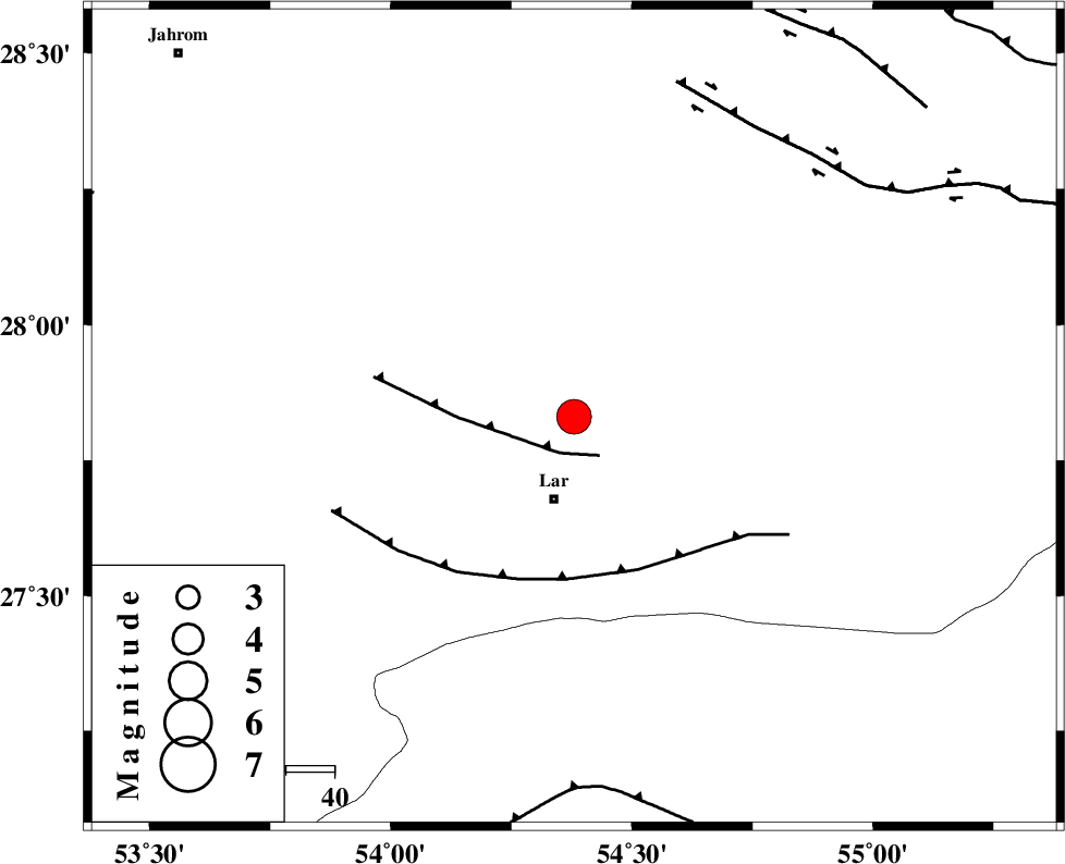
| Location | Lat:27.83 Lon: 54.38 |
| Region | 17 km North of Lar, Fars Province |
Nearest Cities |
|
| 5 km of Dehkuyeh, Fars Province | |
| 15 km North of Latifi, Fars Province | |
| 17 km North of Lar, Fars Province | |
| 29 km North East of Grash, Fars Province | |
| 37 km North East of Avaz, Fars Province | |
| Depth | 46 km |
| Agency | |
Faults within 150 km: |
|
| BERIZ_F (Length: 49 km) , Distance to epicenter: 8 km | |
| LAR_F (Length: 99 km) , Distance to epicenter: 33 km | |
| HZF2 (Length: 437 km) , Distance to epicenter: 70 km | |
| Number of Phases | 7 |
| RMS | 0.4 |
| Number of Stations | 5 |
| Error in Latitude | >6.7 km |
| Error in Longitude | 5 km |
| Error in Depth | 8.8 km |
Download waveform in seisan format
to download seisan software Click here
to access information about IIEES stations Click here
Amplitude | ||||||||
| UID | Agency | Station | Component | Amplitude | Period | Arrival Time | Proccessing Time | Signal Clip |
| 35058 | IIEES | GHIR | E | 16433.8 | 0.8 | 2006-06-23 16:01:24 | 2008-03-02 12:02:00 | n |
| 35059 | IIEES | GHIR | N | 9611.9 | 0.52 | 2006-06-23 16:01:27 | 2008-03-02 12:02:00 | n |
| 35060 | IIEES | BNDS | N | 2456.3 | 0.67 | 2006-06-23 16:01:49 | 2008-03-02 12:02:00 | n |
Phase | ||||||||||||
| Agency | Station | Component | Phase Type | Phase Quality | First Motion | Observed Arrival Time | Time Residual | Loc. Flag | Input Weight | Distance | Azimuth | |
| IIEES | GHIR | Z | PG | E | 2006-06-23 16:01:03 | -0.5 | y | 146 | 290 | |||
| IIEES | GHIR | E | Sg | E | 2006-06-23 16:01:21 | 0.4 | y | 146 | 290 | |||
| IIEES | BNDS | Z | PG | E | 2006-06-23 16:01:09 | 0.1 | y | 183 | 105 | |||
| IIEES | NASN | Z | Pn | E | 2006-06-23 16:01:54 | 0.5 | y | 571 | 345 | |||
| IIEES | NASN | E | Sg | E | 2006-06-23 16:03:13 | -0.1 | y | 571 | 345 | |||
| IIEES | ASAO | Z | Pn | E | 2006-06-23 16:02:28 | -0.7 | y | 852 | 332 | |||
| IIEES | DAMV | Z | Pn | E | 2006-06-23 16:02:34 | 0 | y | 894 | 346 | |||