
Magnitude |
:3.3 |
| Date & Time (UTC) | 2006-05-30 13:32:55.4 |
| Date & Time (Local) | 1385/3/9 17:02:55.4 |
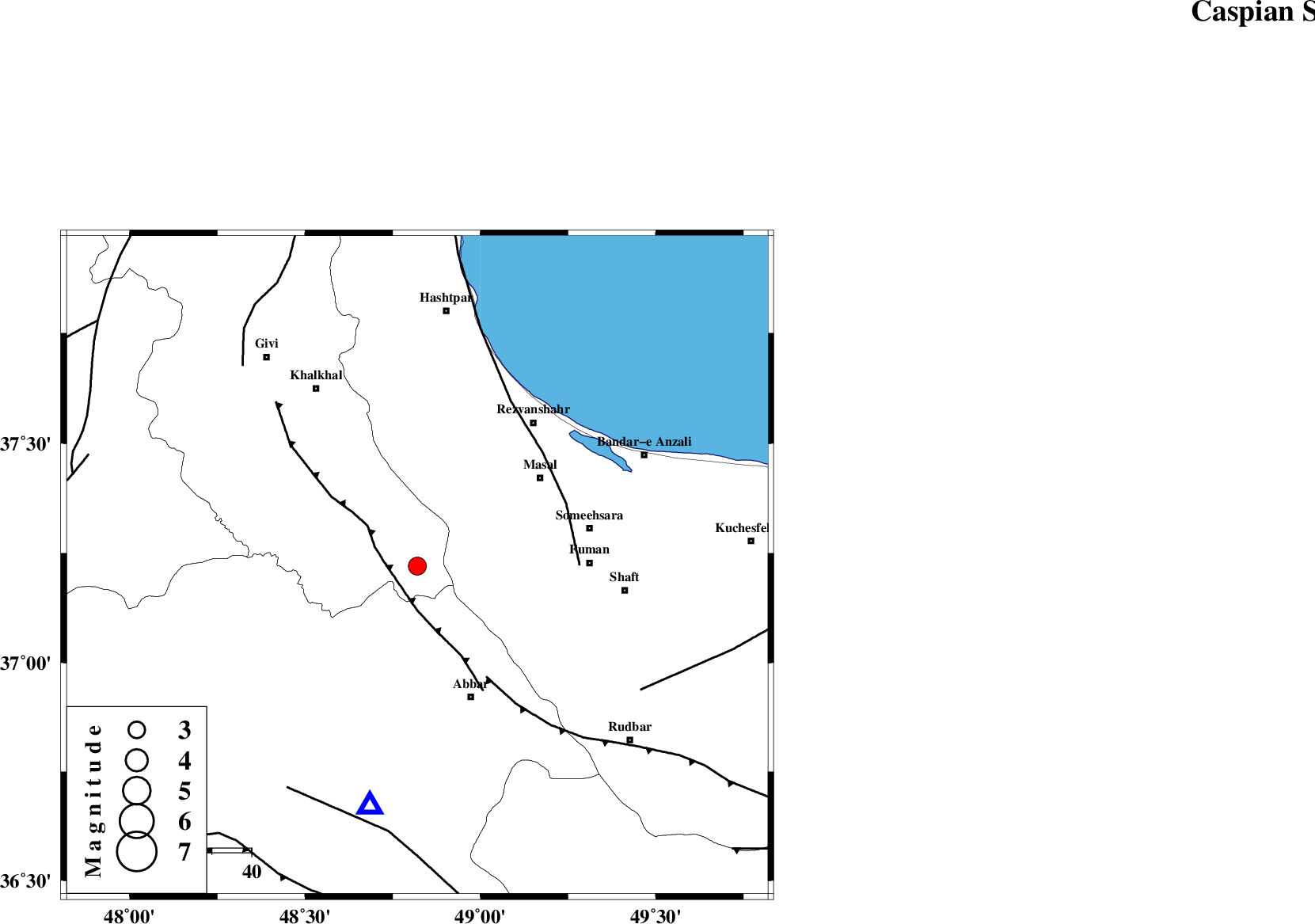
| Location | Lat:37.22 Lon: 48.82 |
| Region | 35 km North-West of Abbar, Zanjan Province |
Nearest Cities |
|
| 13 km South of Shal, Ardebil Province | |
| 17 km North East of Barandaq, Ardebil Province | |
| 17 km East of Karin, Ardebil Province | |
| 21 km South East of Kalur, Ardebil Province | |
| 21 km North of Deram, Zanjan Province | |
| Depth | 14 km |
| Agency | |
Faults within 150 km: |
|
| MASULEL_F (Length: 90 km) , Distance to epicenter: 6 km | |
| RUDBAR_F (Length: 93 km) , Distance to epicenter: 33 km | |
| TALESH_F (Length: 258 km) , Distance to epicenter: 41 km | |
| Number of Phases | 7 |
| RMS | 0.1 |
| Number of Stations | 7 |
| Error in Latitude | >2.8 km |
| Error in Longitude | 3.4 km |
| Error in Depth | 4.6 km |
Download waveform in seisan format
to download seisan software Click here
to access information about IIEES stations Click here
Amplitude | ||||||||
| UID | Agency | Station | Component | Amplitude | Period | Arrival Time | Proccessing Time | Signal Clip |
| 34696 | IIEES | GRMI | E | 227.8 | 0.41 | 2006-05-30 13:33:54 | 2008-03-02 12:02:00 | n |
| 34697 | IIEES | THKV | N | 192.4 | 0.06 | 2006-05-30 13:34:05 | 2008-03-02 12:02:00 | n |
| 34698 | IIEES | THKV | E | 248.5 | 0.57 | 2006-05-30 13:34:09 | 2008-03-02 12:02:00 | n |
| 34699 | IIEES | SNGE | N | 127.4 | 0.32 | 2006-05-30 13:34:13 | 2008-03-02 12:02:00 | n |
| 34700 | IIEES | DAMV | E | 84.2 | 0.84 | 2006-05-30 13:34:30 | 2008-03-02 12:02:00 | n |
| 34701 | IIEES | DAMV | N | 75.7 | 0.77 | 2006-05-30 13:34:31 | 2008-03-02 12:02:00 | n |
Phase | ||||||||||||
| Agency | Station | Component | Phase Type | Phase Quality | First Motion | Observed Arrival Time | Time Residual | Loc. Flag | Input Weight | Distance | Azimuth | |
| IIEES | GRMI | Z | PG | E | 2006-05-30 13:33:27 | 0 | y | 195 | 336 | |||
| IIEES | THKV | Z | PG | E | 2006-05-30 13:33:33 | 0 | y | 234 | 127 | |||
| IIEES | CHTH | Z | PN | E | 2006-05-30 13:33:34 | 0.2 | y | 252 | 124 | |||
| IIEES | SNGE | Z | PN | E | 2006-05-30 13:33:36 | 0.1 | y | 270 | 210 | |||
| IIEES | ASAO | Z | PN | E | 2006-05-30 13:33:42 | -0.2 | y | 315 | 159 | |||
| IIEES | DAMV | Z | PN | E | 2006-05-30 13:33:44 | 0 | y | 333 | 121 | |||
| IIEES | MAKU | Z | PN | E | 2006-05-30 13:33:56 | -0.1 | y | 433 | 305 | |||