
Magnitude |
:3.2 |
| Date & Time (UTC) | 2004-12-29 22:39:53.2 |
| Date & Time (Local) | 1383/10/10 02:09:53.2 |
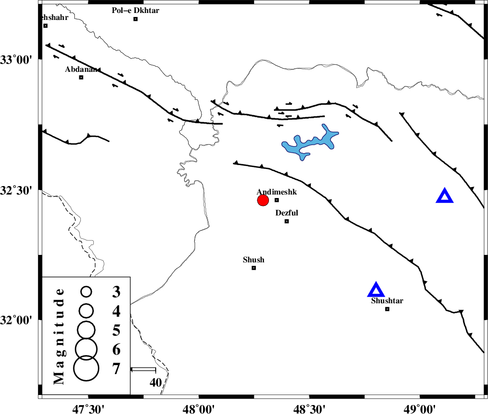
| Location | Lat:32.46 Lon: 48.29 |
| Region | 5 km Andimeshk, Khoozestan Province |
Nearest Cities |
|
| 6 km North of Andimeshk, Khoozestan Province | |
| 14 km North West of Dezful, Khoozestan Province | |
| 22 km North West of Shamsabad, Khoozestan Province | |
| 25 km South of Hoseinieh, Khoozestan Province | |
| 29 km North of Shush, Khoozestan Province | |
| Depth | 31 km |
| Agency | |
Faults within 150 km: |
|
| DEZFUL_EMBAYMENT (Length: 228 km) , Distance to epicenter: 14 km | |
| BALARUD_F_Z3 (Length: 53 km) , Distance to epicenter: 35 km | |
| BALARUD_F_Z1 (Length: 87 km) , Distance to epicenter: 37 km | |
| Number of Phases | 6 |
| RMS | 0.2 |
| Number of Stations | 5 |
| Error in Latitude | >2.9 km |
| Error in Longitude | 6.3 km |
| Error in Depth | 5.4 km |
Download waveform in seisan format
to download seisan software Click here
to access information about IIEES stations Click here
Amplitude | ||||||||
| UID | Agency | Station | Component | Amplitude | Period | Arrival Time | Proccessing Time | Signal Clip |
| 31455 | IIEES | SHGR | E | 1538.1 | 0.8 | 2004-12-29 22:40:31 | 2006-03-15 11:56:00 | n |
| 31456 | IIEES | SHGR | N | 710.9 | 0.6 | 2004-12-29 22:40:33 | 2006-03-15 11:56:00 | n |
| 31457 | IIEES | ASAO | N | 113.4 | 0.88 | 2004-12-29 22:41:19 | 2006-03-15 11:56:00 | n |
| 31458 | IIEES | ASAO | E | 132.7 | 0.64 | 2004-12-29 22:41:20 | 2006-03-15 11:56:00 | n |
Phase | ||||||||||||
| Agency | Station | Component | Phase Type | Phase Quality | First Motion | Observed Arrival Time | Time Residual | Loc. Flag | Input Weight | Distance | Azimuth | |
| IIEES | SHGR | Z | PG | E | 2004-12-29 22:40:04 | 0 | y | 62 | 129 | |||
| IIEES | ASAO | Z | PN | E | 2004-12-29 22:40:34 | 0.3 | y | 282 | 34 | |||
| IIEES | ASAO | N | SG | E | 2004-12-29 22:41:11 | 0 | y | 282 | 34 | |||
| IIEES | SNGE | Z | PN | E | 2004-12-29 22:40:37 | 0 | y | 305 | 344 | |||
| IIEES | NASN | Z | PN | E | 2004-12-29 22:40:52 | 0 | y | 426 | 84 | |||
| IIEES | DAMV | Z | PN | E | 2004-12-29 22:40:59 | -0.4 | y | 489 | 43 | |||