
Magnitude |
:3.2 |
| Date & Time (UTC) | 2004-12-05 01:24:56.9 |
| Date & Time (Local) | 1383/9/15 04:54:56.9 |
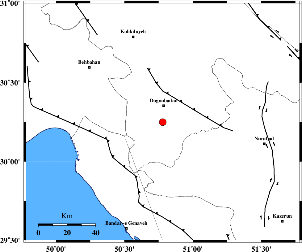
| Location | Lat:30.25 Lon: 50.78 |
| Region | 11 km South of Dogonbadan, Kohkiluieh va boyerahmad Province |
Nearest Cities |
|
| 11 km South of Dogonbadan, Kohkiluieh va boyerahmad Province | |
| 34 km South West of Abdehgah, Kohkiluieh va boyerahmad Province | |
| 39 km South West of Basht, Kohkiluieh va boyerahmad Province | |
| 45 km North West of Babamonir, Fars Province | |
| 48 km North East of Siyahmakan-e bozorg, Bushehr Province | |
| Depth | 15 km |
| Agency | |
Faults within 150 km: |
|
| MISHAN_F (Length: 76 km) , Distance to epicenter: 19 km | |
| ZFF3 (Length: 125 km) , Distance to epicenter: 41 km | |
| RAG_E_SEFID_F (Length: 84 km) , Distance to epicenter: 41 km | |
| Number of Phases | 6 |
| RMS | 0.2 |
| Number of Stations | 6 |
| Error in Latitude | >4.8 km |
| Error in Longitude | 2.4 km |
| Error in Depth | 0 km |
Download waveform in seisan format
to download seisan software Click here
to access information about IIEES stations Click here
Amplitude | ||||||||
| UID | Agency | Station | Component | Amplitude | Period | Arrival Time | Proccessing Time | Signal Clip |
| 31319 | IIEES | SHGO | E | 111 | 0.75 | 2004-12-05 01:26:32 | 2006-03-15 11:56:00 | n |
| 31320 | IIEES | SHGO | N | 107.3 | 0.7 | 2004-12-05 01:26:43 | 2006-03-15 11:56:00 | n |
| 31321 | IIEES | GHIR | E | 104.9 | 0.72 | 2004-12-05 01:26:45 | 2006-03-15 11:56:00 | n |
| 31322 | IIEES | GHIR | N | 119.4 | 0.56 | 2004-12-05 01:26:52 | 2006-03-15 11:56:00 | n |
| 31323 | IIEES | ASAO | N | 15.3 | 0.68 | 2004-12-05 01:27:05 | 2006-03-15 11:56:00 | n |
Phase | ||||||||||||
| Agency | Station | Component | Phase Type | Phase Quality | First Motion | Observed Arrival Time | Time Residual | Loc. Flag | Input Weight | Distance | Azimuth | |
| IIEES | SHGO | Z | PN | E | 2004-12-05 01:25:39 | 0.2 | y | 279 | 318 | |||
| IIEES | GHIR | Z | PN | E | 2004-12-05 01:25:42 | -0.2 | y | 306 | 135 | |||
| IIEES | NASN | Z | PN | E | 2004-12-05 01:25:47 | -0.2 | y | 342 | 34 | |||
| IIEES | ASAO | Z | PN | E | 2004-12-05 01:26:04 | 0 | y | 482 | 352 | |||
| IIEES | KRBR | Z | PN | E | 2004-12-05 01:26:16 | 0.5 | y | 577 | 91 | |||
| IIEES | SNGE | Z | PN | E | 2004-12-05 01:26:22 | -0.2 | y | 626 | 330 | |||