
Magnitude |
:3.1 |
| Date & Time (UTC) | 2004-12-04 23:07:46.6 |
| Date & Time (Local) | 1383/9/15 02:37:46.6 |
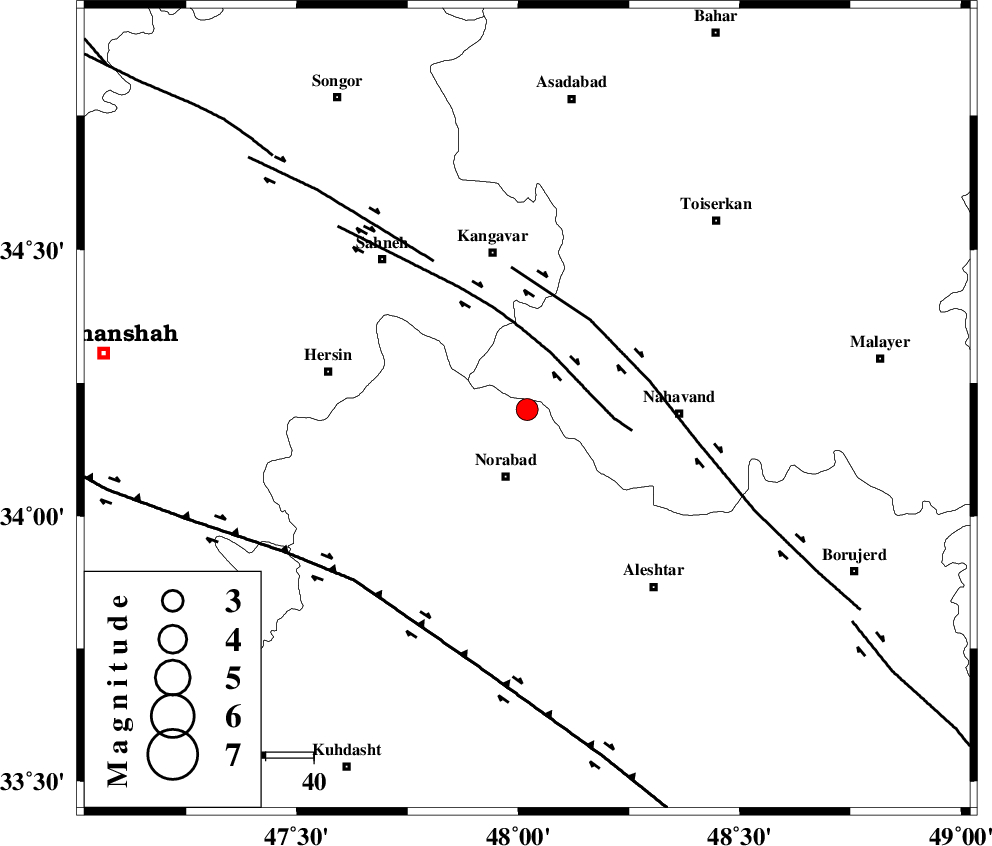
| Location | Lat:34.2 Lon: 48.02 |
| Region | 14 km North of Nurabad, Lorestan Province |
Nearest Cities |
|
| 8 km North of Froozvand-e vosta, Lorestan Province | |
| 13 km North of Kafraj, Lorestan Province | |
| 15 km West of Shahrak, Hamedan Province | |
| 15 km North of Nurabad, Lorestan Province | |
| 18 km North East of Zafarabad, Lorestan Province | |
| Depth | 14 km |
| Agency | |
Faults within 150 km: |
|
| SAHANEH_F (Length: 77 km) , Distance to epicenter: 13 km | |
| NAHAVAND_F (Length: 102 km) , Distance to epicenter: 23 km | |
| DINEHVAR_F (Length: 46 km) , Distance to epicenter: 36 km | |
| Number of Phases | 5 |
| RMS | 0.4 |
| Number of Stations | 5 |
| Error in Latitude | >7.3 km |
| Error in Longitude | 11.2 km |
| Error in Depth | 16.1 km |
Download waveform in seisan format
to download seisan software Click here
to access information about IIEES stations Click here
Amplitude | ||||||||
| UID | Agency | Station | Component | Amplitude | Period | Arrival Time | Proccessing Time | Signal Clip |
| 31304 | IIEES | SNGE | N | 886.5 | 0.4 | 2004-12-04 23:08:27 | 2006-03-15 11:56:00 | n |
| 31305 | IIEES | ASAO | N | 249.2 | 0.67 | 2004-12-04 23:08:45 | 2006-03-15 11:56:00 | n |
| 31306 | IIEES | ASAO | E | 208.7 | 0.6 | 2004-12-04 23:08:54 | 2006-03-15 11:56:00 | n |
| 31307 | IIEES | SHGO | N | 106.9 | 0.6 | 2004-12-04 23:09:09 | 2006-03-15 11:56:00 | n |
| 31308 | IIEES | SHGO | E | 86.7 | 0.4 | 2004-12-04 23:09:13 | 2006-03-15 11:56:00 | n |
Phase | ||||||||||||
| Agency | Station | Component | Phase Type | Phase Quality | First Motion | Observed Arrival Time | Time Residual | Loc. Flag | Input Weight | Distance | Azimuth | |
| IIEES | SNGE | Z | PG | E | 2004-12-04 23:08:06 | 0 | y | 117 | 329 | |||
| IIEES | ASAO | Z | PG | E | 2004-12-04 23:08:17 | -0.6 | y | 189 | 78 | |||
| IIEES | SHGO | Z | PG | E | 2004-12-04 23:08:26 | -0.2 | y | 243 | 162 | |||
| IIEES | DAMV | Z | PN | E | 2004-12-04 23:08:43 | 0.4 | y | 395 | 65 | |||
| IIEES | NASN | Z | PN | E | 2004-12-04 23:08:53 | 0.7 | y | 472 | 108 | |||