
Magnitude |
:2.9 |
| Date & Time (UTC) | 2004-12-01 07:13:45.5 |
| Date & Time (Local) | 1383/9/11 10:43:45.5 |
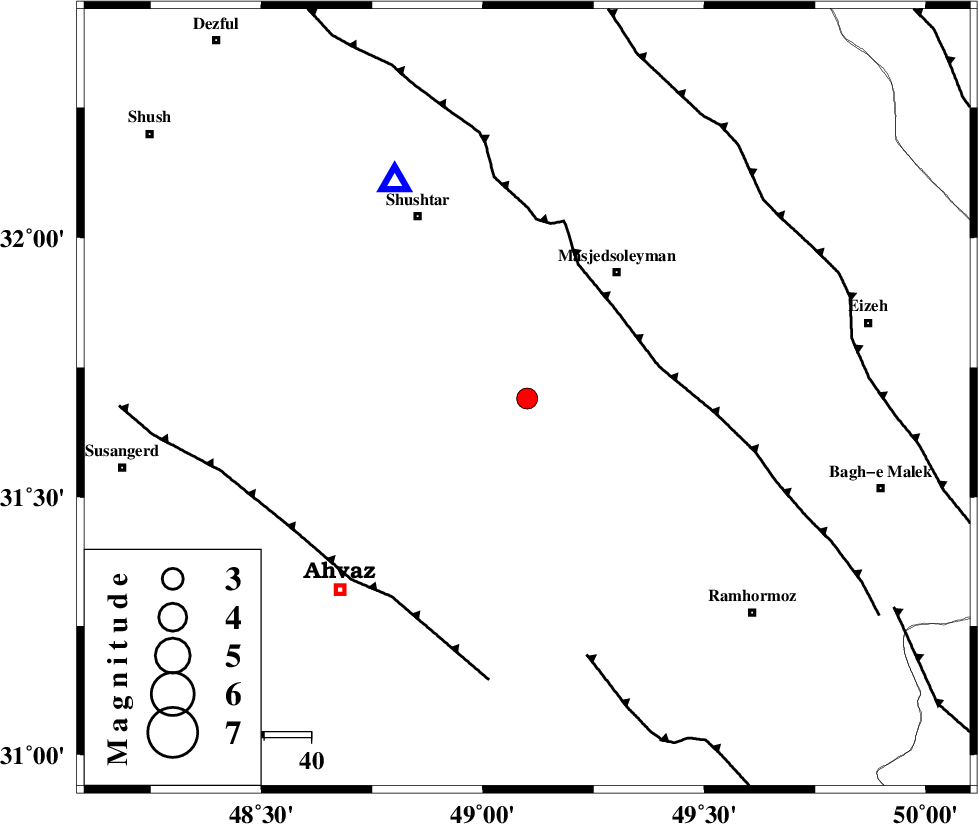
| Location | Lat:31.69 Lon: 49.1 |
| Region | 32 km South-West of Masjed Soleyman, Khoozestan Province |
Nearest Cities |
|
| 18 km North East of Talieh, Khoozestan Province | |
| 24 km North East of Mollasani, Khoozestan Province | |
| 25 km South East of Arabhasan, Khoozestan Province | |
| 30 km North West of Gazin, Khoozestan Province | |
| 31 km North East of Veys, Khoozestan Province | |
| Depth | 18 km |
| Agency | |
Faults within 150 km: |
|
| DEZFUL_EMBAYMENT (Length: 228 km) , Distance to epicenter: 27 km | |
| AHVAZ_F (Length: 99 km) , Distance to epicenter: 51 km | |
| AGHAJARI_F (Length: 88 km) , Distance to epicenter: 57 km | |
| Number of Phases | 5 |
| RMS | 0.2 |
| Number of Stations | 3 |
| Error in Latitude | >11.9 km |
| Error in Longitude | 4.3 km |
| Error in Depth | 8.9 km |
Download waveform in seisan format
to download seisan software Click here
to access information about IIEES stations Click here
Amplitude | ||||||||
| UID | Agency | Station | Component | Amplitude | Period | Arrival Time | Proccessing Time | Signal Clip |
| 31288 | IIEES | SHGR | N | 1062.2 | 0.4 | 2004-12-01 07:14:08 | 2006-03-15 11:56:00 | n |
| 31289 | IIEES | SHGR | E | 715.4 | 0.32 | 2004-12-01 07:14:09 | 2006-03-15 11:56:00 | n |
| 31290 | IIEES | SNGE | N | 23 | 0.52 | 2004-12-01 07:15:47 | 2006-03-15 11:56:00 | n |
Phase | ||||||||||||
| Agency | Station | Component | Phase Type | Phase Quality | First Motion | Observed Arrival Time | Time Residual | Loc. Flag | Input Weight | Distance | Azimuth | |
| IIEES | SHGR | Z | PG | E | 2004-12-01 07:13:55 | 0.3 | y | 54.1 | 328 | |||
| IIEES | SHGR | N | SG | E | 2004-12-01 07:14:02 | -0.2 | y | 54.1 | 328 | |||
| IIEES | NASN | Z | PN | E | 2004-12-01 07:14:38 | -0.3 | y | 370 | 70 | |||
| IIEES | NASN | E | SG | E | 2004-12-01 07:15:29 | 0.1 | y | 370 | 70 | |||
| IIEES | SNGE | Z | PN | E | 2004-12-01 07:14:43 | 0 | y | 411 | 337 | |||