
Magnitude |
:2.9 |
| Date & Time (UTC) | 2004-12-01 03:59:33.8 |
| Date & Time (Local) | 1383/9/11 07:29:33.8 |
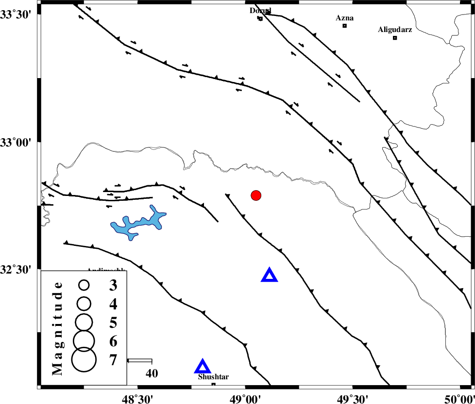
| Location | Lat:32.79 Lon: 49.05 |
| Region | 44 km North of Lali, Khoozestan Province |
Nearest Cities |
|
| 22 km East of Shuy, Khoozestan Province | |
| 30 km South East of Bargsar, Lorestan Province | |
| 38 km North East of Sardasht, Khoozestan Province | |
| 42 km South West of Parchal, Lorestan Province | |
| 45 km North of Lali, Khoozestan Province | |
| Depth | 10 km |
| Agency | |
Faults within 150 km: |
|
| MFF2 (Length: 205 km) , Distance to epicenter: 11 km | |
| BALARUD_F_Z2 (Length: 58 km) , Distance to epicenter: 20 km | |
| HZF4 (Length: 492 km) , Distance to epicenter: 40 km | |
| Number of Phases | 4 |
| RMS | 0.4 |
| Number of Stations | 3 |
| Error in Latitude | >3.6 km |
| Error in Longitude | 7.9 km |
| Error in Depth | 0 km |
Download waveform in seisan format
to download seisan software Click here
to access information about IIEES stations Click here
Amplitude | ||||||||
| UID | Agency | Station | Component | Amplitude | Period | Arrival Time | Proccessing Time | Signal Clip |
| 31281 | IIEES | SHGR | E | 880.9 | 0.32 | 2004-12-01 04:00:01 | 2006-03-15 11:56:00 | n |
| 31282 | IIEES | SHGR | Z | 579.8 | 0.44 | 2004-12-01 04:00:07 | 2006-03-15 11:56:00 | n |
| 31283 | IIEES | SNGE | N | 32.1 | 0.52 | 2004-12-01 04:01:15 | 2006-03-15 11:56:00 | n |
Phase | ||||||||||||
| Agency | Station | Component | Phase Type | Phase Quality | First Motion | Observed Arrival Time | Time Residual | Loc. Flag | Input Weight | Distance | Azimuth | |
| IIEES | SHGR | Z | PG | E | 2004-12-01 03:59:47 | -0.6 | y | 78.9 | 197 | |||
| IIEES | SHGR | N | SG | E | 2004-12-01 03:59:58 | 0.4 | y | 78.9 | 197 | |||
| IIEES | SNGE | Z | PN | E | 2004-12-01 04:00:19 | 0.1 | y | 300 | 329 | |||
| IIEES | NASN | Z | PN | E | 2004-12-01 04:00:26 | 0.1 | y | 352 | 89 | |||