
Magnitude |
:2.9 |
| Date & Time (UTC) | 2004-11-30 05:33:34.0 |
| Date & Time (Local) | 1383/9/10 09:03:34.0 |
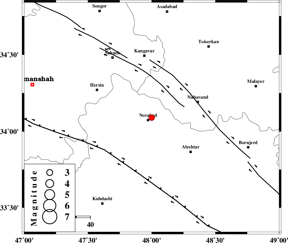
| Location | Lat:34.09 Lon: 48 |
| Region | 3 km Nurabad, Lorestan Province |
Nearest Cities |
|
| 3 km North of Nurabad, Lorestan Province | |
| 4 km of Froozvand-e vosta, Lorestan Province | |
| 5 km of Kafraj, Lorestan Province | |
| 9 km North of Zafarabad, Lorestan Province | |
| 13 km North of Farhadabad, Lorestan Province | |
| Depth | 18 km |
| Agency | |
Faults within 150 km: |
|
| SAHANEH_F (Length: 77 km) , Distance to epicenter: 21 km | |
| NAHAVAND_F (Length: 102 km) , Distance to epicenter: 33 km | |
| HZF4 (Length: 492 km) , Distance to epicenter: 41 km | |
| Number of Phases | 6 |
| RMS | 0.2 |
| Number of Stations | 5 |
| Error in Latitude | >6.9 km |
| Error in Longitude | 17.7 km |
| Error in Depth | 18.1 km |
Download waveform in seisan format
to download seisan software Click here
to access information about IIEES stations Click here
Amplitude | ||||||||
| UID | Agency | Station | Component | Amplitude | Period | Arrival Time | Proccessing Time | Signal Clip |
| 31266 | IIEES | SNGE | N | 197.9 | 0.48 | 2004-11-30 05:34:18 | 2006-03-15 11:56:00 | n |
| 31267 | IIEES | SHGR | E | 96.2 | 0.31 | 2004-11-30 05:34:42 | 2006-03-15 11:56:00 | n |
| 31268 | IIEES | SHGR | N | 81.8 | 0.43 | 2004-11-30 05:34:43 | 2006-03-15 11:56:00 | n |
Phase | ||||||||||||
| Agency | Station | Component | Phase Type | Phase Quality | First Motion | Observed Arrival Time | Time Residual | Loc. Flag | Input Weight | Distance | Azimuth | |
| IIEES | SNGE | Z | PG | E | 2004-11-30 05:33:55 | 0.2 | y | 126 | 332 | |||
| IIEES | SHGR | Z | PG | E | 2004-11-30 05:34:11 | -0.4 | y | 232 | 161 | |||
| IIEES | SHGR | N | SG | E | 2004-11-30 05:34:39 | 0.3 | y | 232 | 161 | |||
| IIEES | DAMV | Z | PN | E | 2004-11-30 05:34:31 | 0 | y | 401 | 64 | |||
| IIEES | NASN | Z | PN | E | 2004-11-30 05:34:40 | 0.2 | y | 469 | 106 | |||
| IIEES | GRMI | Z | PN | E | 2004-11-30 05:34:46 | -0.2 | y | 524 | 359 | |||