
Magnitude |
:3.5 |
| Date & Time (UTC) | 2004-11-26 18:48:21.8 |
| Date & Time (Local) | 1383/9/6 22:18:21.8 |
| Location | Lat:29.85 Lon: 51.43 |
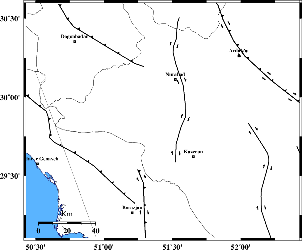
| Region | 30 km South of Nurabad, Fars Province |
Nearest Cities |
|
| 20 km North West of Seyyed hasan, Fars Province | |
| 24 km North West of Deris, Fars Province | |
| 25 km North of Kamaraj, Fars Province | |
| 27 km North West of Nodan, Fars Province | |
| 28 km South West of Gachgaran, Fars Province | |
| Depth | 14 km |
| Agency | |
Faults within 150 km: |
|
| KAZERUN_F (Length: 96 km) , Distance to epicenter: 14 km | |
| BORAZJAN_F (Length: 168 km) , Distance to epicenter: 39 km | |
| MISHAN_F (Length: 76 km) , Distance to epicenter: 40 km | |
| Number of Phases | 5 |
| RMS | 0.1 |
| Number of Stations | 5 |
| Error in Latitude | >8.7 km |
| Error in Longitude | 5.5 km |
| Error in Depth | 16.7 km |
Download waveform in seisan format
to download seisan software Click here
to access information about IIEES stations Click here
Amplitude | ||||||||
| UID | Agency | Station | Component | Amplitude | Period | Arrival Time | Proccessing Time | Signal Clip |
| 31241 | IIEES | GHIR | E | 322.4 | 0.56 | 2004-11-26 18:49:38 | 2006-03-15 11:56:00 | n |
| 31242 | IIEES | GHIR | N | 394.8 | 0.56 | 2004-11-26 18:49:47 | 2006-03-15 11:56:00 | n |
| 31243 | IIEES | SHGO | N | 132.4 | 0.7 | 2004-11-26 18:50:24 | 2006-03-15 11:56:00 | n |
| 31244 | IIEES | SHGO | E | 130.1 | 0.65 | 2004-11-26 18:50:35 | 2006-03-15 11:56:00 | n |
Phase | ||||||||||||
| Agency | Station | Component | Phase Type | Phase Quality | First Motion | Observed Arrival Time | Time Residual | Loc. Flag | Input Weight | Distance | Azimuth | |
| IIEES | GHIR | Z | PG | E | 2004-11-26 18:48:59 | 0 | y | 230 | 138 | |||
| IIEES | NASN | Z | PN | E | 2004-11-26 18:49:13 | 0.1 | y | 353 | 21 | |||
| IIEES | SHGO | Z | PN | E | 2004-11-26 18:49:13 | 0.1 | y | 355 | 316 | |||
| IIEES | KRBR | Z | PN | E | 2004-11-26 18:49:33 | 0.1 | y | 515 | 87 | |||
| IIEES | ASAO | N | PN | E | 2004-11-26 18:49:36 | -0.3 | y | 538 | 346 | |||