
Magnitude |
:3.3 |
| Date & Time (UTC) | 2004-11-25 04:20:25.7 |
| Date & Time (Local) | 1383/9/5 07:50:25.7 |
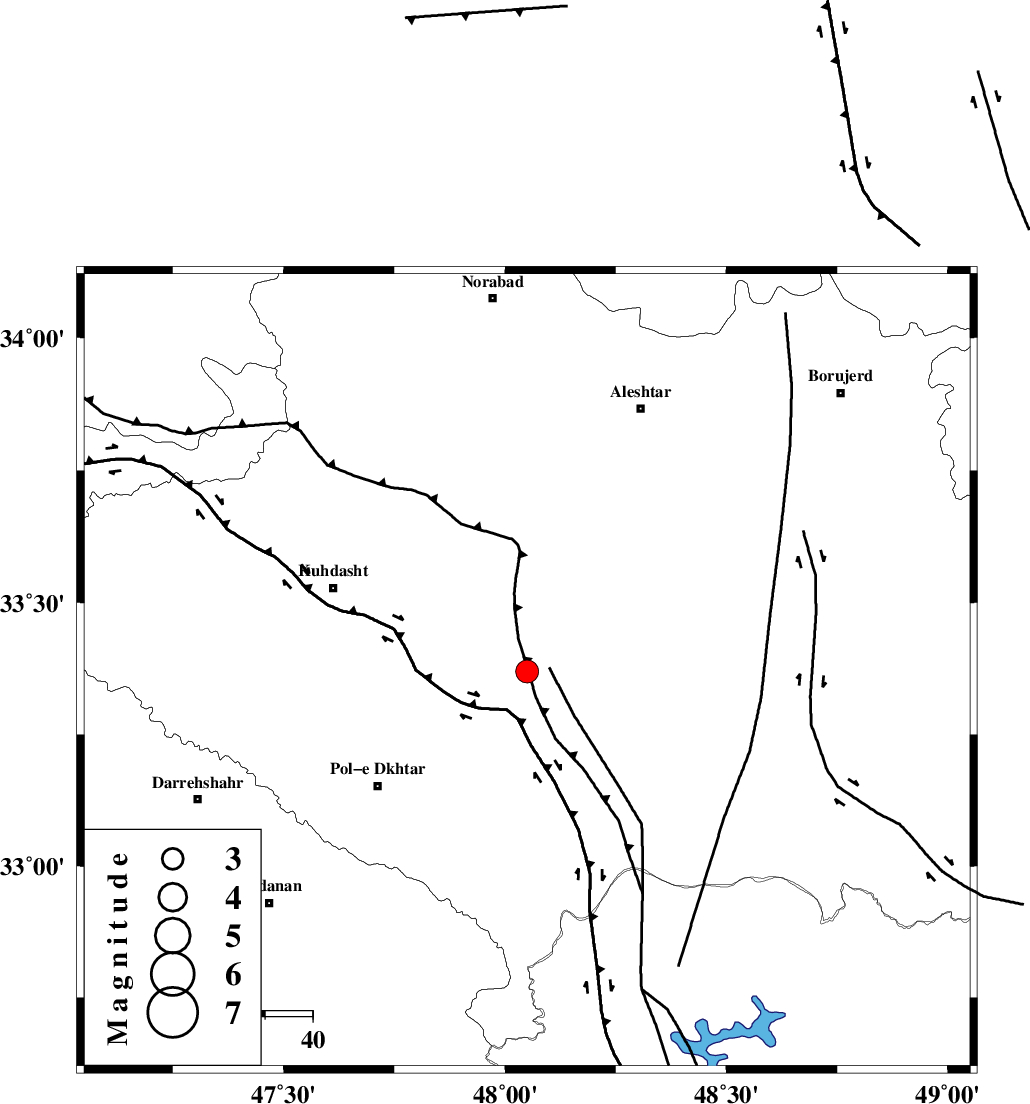
| Location | Lat:33.37 Lon: 48.05 |
| Region | 32 km South-West of Khorramabad, Lorestan Province |
Nearest Cities |
|
| 7 km of Maeulan, Lorestan Province | |
| 13 km of Godar-e mahmudvand, Lorestan Province | |
| 13 km South of Mahmudvand, Lorestan Province | |
| 14 km West of Shoorab-e sofla, Lorestan Province | |
| 21 km South of Sarabboreh, Lorestan Province | |
| Depth | 18 km |
| Agency | |
Faults within 150 km: |
|
| HZF4 (Length: 492 km) , Distance to epicenter: 24 km | |
| BALARUD_F_Z3 (Length: 53 km) , Distance to epicenter: 59 km | |
| BALARUD_F_Z1 (Length: 87 km) , Distance to epicenter: 62 km | |
| Number of Phases | 6 |
| RMS | 0.4 |
| Number of Stations | 5 |
| Error in Latitude | >5.5 km |
| Error in Longitude | 11.3 km |
| Error in Depth | 13 km |
Download waveform in seisan format
to download seisan software Click here
to access information about IIEES stations Click here
Amplitude | ||||||||
| UID | Agency | Station | Component | Amplitude | Period | Arrival Time | Proccessing Time | Signal Clip |
| 31209 | IIEES | SHGR | E | 760.5 | 0.44 | 2004-11-25 04:21:20 | 2006-03-15 11:56:00 | n |
| 31210 | IIEES | SHGR | N | 678.3 | 0.52 | 2004-11-25 04:21:23 | 2006-03-15 11:56:00 | n |
| 31211 | IIEES | SNGE | N | 208 | 0.6 | 2004-11-25 04:21:27 | 2006-03-15 11:56:00 | n |
| 31212 | IIEES | ASAO | E | 140.7 | 0.48 | 2004-11-25 04:21:40 | 2006-03-15 11:56:00 | n |
Phase | ||||||||||||
| Agency | Station | Component | Phase Type | Phase Quality | First Motion | Observed Arrival Time | Time Residual | Loc. Flag | Input Weight | Distance | Azimuth | |
| IIEES | SHGR | Z | PG | E | 2004-11-25 04:20:51 | 0.1 | y | 157 | 153 | |||
| IIEES | SNGE | Z | PG | E | 2004-11-25 04:20:58 | -0.5 | y | 201 | 342 | |||
| IIEES | SNGE | N | SG | E | 2004-11-25 04:21:23 | 0.4 | y | 201 | 342 | |||
| IIEES | ASAO | E | PG | E | 2004-11-25 04:21:02 | 0 | y | 225 | 54 | |||
| IIEES | THKV | Z | PN | E | 2004-11-25 04:21:20 | -0.4 | y | 383 | 42 | |||
| IIEES | DAMV | Z | PN | E | 2004-11-25 04:21:28 | 0.5 | y | 439 | 54 | |||