
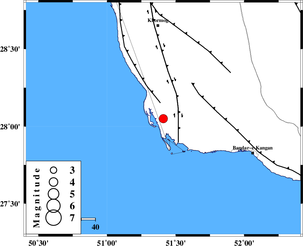
Magnitude |
:3.9 |
| Date & Time (UTC) | 2004-11-22 18:36:50.4 |
| Date & Time (Local) | 1383/9/2 22:06:50.4 |
| Location | Lat:28.05 Lon: 51.41 |
| Region | 67 km South of Khormog, Bushehr Province |
Nearest Cities |
|
| 6 km of Bardkhun, Bushehr Province | |
| 14 km South of Ziyarat, Bushehr Province | |
| 17 km South West of Abkesh, Bushehr Province | |
| 34 km South West of Kaki, Bushehr Province | |
| 34 km West of Abdan, Bushehr Province | |
| Depth | 26 km |
| Agency | |
Faults within 150 km: |
|
| ZFF2 (Length: 84 km) , Distance to epicenter: 12 km | |
| BORAZJAN_F (Length: 168 km) , Distance to epicenter: 13 km | |
| MFF3 (Length: 292 km) , Distance to epicenter: 31 km | |
| Number of Phases | 6 |
| RMS | 0.4 |
| Number of Stations | 5 |
| Error in Latitude | >12.2 km |
| Error in Longitude | 11.2 km |
| Error in Depth | 14.2 km |
Download waveform in seisan format
to download seisan software Click here
to access information about IIEES stations Click here
Amplitude | ||||||||
| UID | Agency | Station | Component | Amplitude | Period | Arrival Time | Proccessing Time | Signal Clip |
| 31189 | IIEES | GHIR | E | 1365 | 0.69 | 2004-11-22 18:37:39 | 2006-03-15 11:56:00 | n |
| 31190 | IIEES | GHIR | N | 2286.3 | 0.56 | 2004-11-22 18:37:39 | 2006-03-15 11:56:00 | n |
Phase | ||||||||||||
| Agency | Station | Component | Phase Type | Phase Quality | First Motion | Observed Arrival Time | Time Residual | Loc. Flag | Input Weight | Distance | Azimuth | |
| IIEES | GHIR | Z | PG | E | 2004-11-22 18:37:16 | 0 | y | 157 | 80 | |||
| IIEES | GHIR | N | SG | E | 2004-11-22 18:37:34 | 0 | y | 157 | 80 | |||
| IIEES | BNDS | Z | PN | E | 2004-11-22 18:37:55 | -0.3 | y | 475 | 98 | |||
| IIEES | NASN | Z | PN | E | 2004-11-22 18:38:04 | -0.6 | y | 543 | 14 | |||
| IIEES | KRBR | Z | PN | E | 2004-11-22 18:38:07 | 0.6 | y | 563 | 66 | |||
| IIEES | ASAO | Z | PN | E | 2004-11-22 18:38:28 | 0.5 | y | 733 | 350 | |||