
Magnitude |
:2.9 |
| Date & Time (UTC) | 2004-11-21 01:53:14.5 |
| Date & Time (Local) | 1383/9/1 05:23:14.5 |
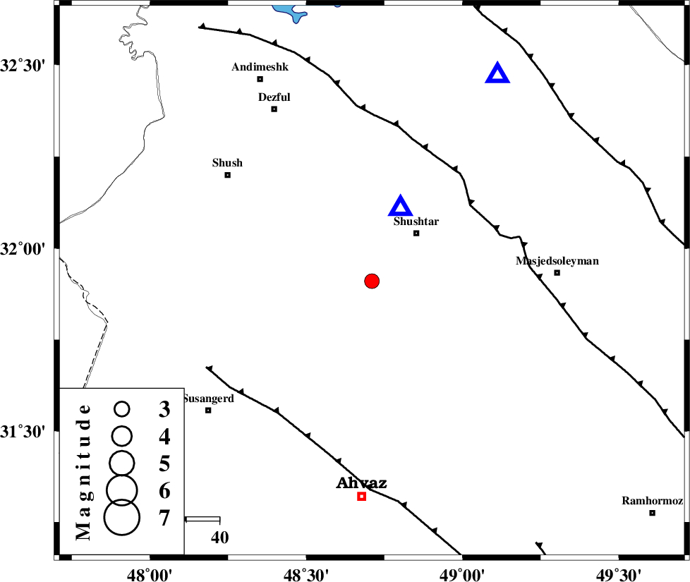
| Location | Lat:31.91 Lon: 48.71 |
| Region | 20 km South-West of Shushtar, Khoozestan Province |
Nearest Cities |
|
| 13 km West of Mehdiabad, Khoozestan Province | |
| 14 km South of Sardarabad, Khoozestan Province | |
| 19 km North West of Arabhasan, Khoozestan Province | |
| 20 km South West of Shushtar, Khoozestan Province | |
| 32 km North East of Abdolkhan-eali, Khoozestan Province | |
| Depth | 5 km |
| Agency | |
Faults within 150 km: |
|
| DEZFUL_EMBAYMENT (Length: 228 km) , Distance to epicenter: 38 km | |
| AHVAZ_F (Length: 99 km) , Distance to epicenter: 49 km | |
| MFF2 (Length: 205 km) , Distance to epicenter: 78 km | |
| Number of Phases | 4 |
| RMS | 0 |
| Number of Stations | 4 |
| Error in Latitude | >10.1 km |
| Error in Longitude | 7 km |
| Error in Depth | 5.8 km |
Download waveform in seisan format
to download seisan software Click here
to access information about IIEES stations Click here
Amplitude | ||||||||
| UID | Agency | Station | Component | Amplitude | Period | Arrival Time | Proccessing Time | Signal Clip |
| 31130 | IIEES | ASAO | N | 47.9 | 0.61 | 2004-11-21 01:54:48 | 2006-03-15 11:56:00 | n |
| 31131 | IIEES | ASAO | E | 23.4 | 0.69 | 2004-11-21 01:54:53 | 2006-03-15 11:56:00 | n |
| 31132 | IIEES | SNGE | N | 39.9 | 0.51 | 2004-11-21 01:55:06 | 2006-03-15 11:56:00 | n |
Phase | ||||||||||||
| Agency | Station | Component | Phase Type | Phase Quality | First Motion | Observed Arrival Time | Time Residual | Loc. Flag | Input Weight | Distance | Azimuth | |
| IIEES | SHGO | Z | PG | E | 2004-11-21 01:53:18 | 0 | y | 23.9 | 21 | |||
| IIEES | ASAO | Z | PN | E | 2004-11-21 01:54:02 | 0 | y | 317 | 22 | |||
| IIEES | SNGE | Z | PN | E | 2004-11-21 01:54:10 | 0 | y | 375 | 341 | |||
| IIEES | NASN | Z | PN | E | 2004-11-21 01:54:13 | 0 | y | 398 | 75 | |||