
Magnitude |
:3.7 |
| Date & Time (UTC) | 2004-11-20 16:10:17.7 |
| Date & Time (Local) | 1383/8/30 19:40:17.7 |
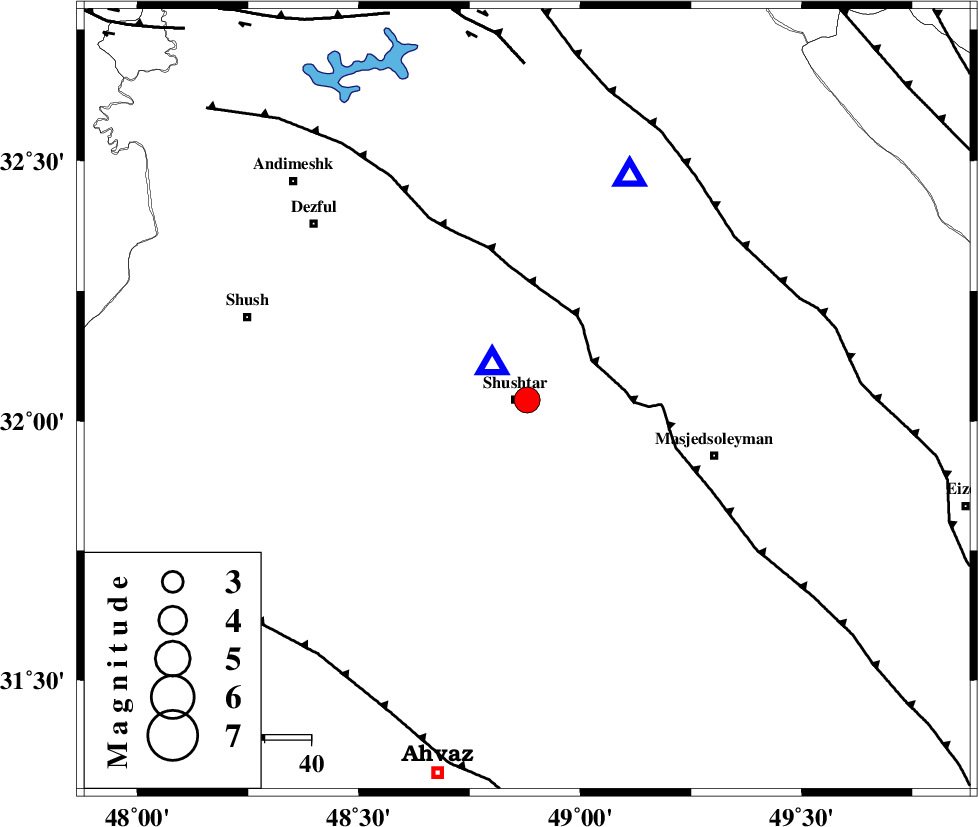
| Location | Lat:32.04 Lon: 48.88 |
| Region | 2 km Shushtar, Khoozestan Province |
Nearest Cities |
|
| 3 km of Shushtar, Khoozestan Province | |
| 9 km North of Sardarabad, Khoozestan Province | |
| 11 km North of Mehdiabad, Khoozestan Province | |
| 18 km South of Samaleh, Khoozestan Province | |
| 20 km West of Haft shahidan, Khoozestan Province | |
| Depth | 6 km |
| Agency | |
Faults within 150 km: |
|
| DEZFUL_EMBAYMENT (Length: 228 km) , Distance to epicenter: 16 km | |
| MFF2 (Length: 205 km) , Distance to epicenter: 56 km | |
| AHVAZ_F (Length: 99 km) , Distance to epicenter: 70 km | |
| Number of Phases | 6 |
| RMS | 0.1 |
| Number of Stations | 6 |
| Error in Latitude | >11 km |
| Error in Longitude | 7.9 km |
| Error in Depth | 5.1 km |
Download waveform in seisan format
to download seisan software Click here
to access information about IIEES stations Click here
Amplitude | ||||||||
| UID | Agency | Station | Component | Amplitude | Period | Arrival Time | Proccessing Time | Signal Clip |
| 31095 | IIEES | ASAO | N | 407.3 | 0.63 | 2004-11-20 16:12:00 | 2006-03-15 11:56:00 | n |
| 31096 | IIEES | ASAO | E | 260.1 | 0.63 | 2004-11-20 16:12:02 | 2006-03-15 11:56:00 | n |
| 31097 | IIEES | SNGE | N | 356.6 | 0.57 | 2004-11-20 16:12:10 | 2006-03-15 11:56:00 | n |
| 31098 | IIEES | NASN | E | 206.2 | 0.64 | 2004-11-20 16:12:16 | 2006-03-15 11:56:00 | n |
| 31099 | IIEES | NASN | N | 139.1 | 0.55 | 2004-11-20 16:12:18 | 2006-03-15 11:56:00 | n |
| 31100 | IIEES | THKV | N | 69 | 0.59 | 2004-11-20 16:12:23 | 2006-03-15 11:56:00 | n |
| 31101 | IIEES | THKV | E | 78.9 | 0.66 | 2004-11-20 16:12:40 | 2006-03-15 11:56:00 | n |
Phase | ||||||||||||
| Agency | Station | Component | Phase Type | Phase Quality | First Motion | Observed Arrival Time | Time Residual | Loc. Flag | Input Weight | Distance | Azimuth | |
| IIEES | SHGO | Z | PG | E | 2004-11-20 16:10:19 | 0 | y | 10.7 | 313 | |||
| IIEES | ASAO | Z | PN | E | 2004-11-20 16:11:03 | 0.2 | y | 298 | 21 | |||
| IIEES | SNGE | Z | PN | E | 2004-11-20 16:11:12 | 0 | y | 367 | 338 | |||
| IIEES | NASN | Z | PN | E | 2004-11-20 16:11:13 | 0 | y | 379 | 76 | |||
| IIEES | THKV | Z | PN | E | 2004-11-20 16:11:24 | -0.2 | y | 468 | 23 | |||
| IIEES | DAMV | Z | PN | E | 2004-11-20 16:11:27 | -0.1 | y | 490 | 35 | |||