
Magnitude |
:4 |
| Date & Time (UTC) | 2004-11-20 14:24:51.5 |
| Date & Time (Local) | 1383/8/30 17:54:51.5 |
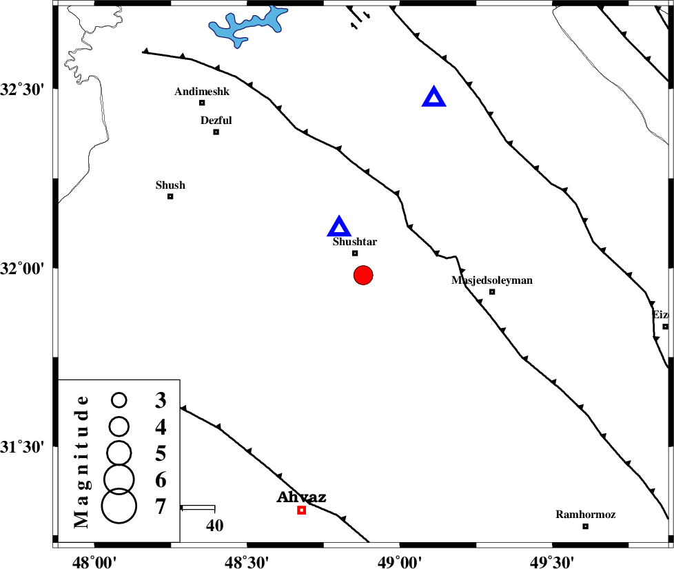
| Location | Lat:31.98 Lon: 48.88 |
| Region | 7 km Shushtar, Khoozestan Province |
Nearest Cities |
|
| 5 km North of Mehdiabad, Khoozestan Province | |
| 7 km of Shushtar, Khoozestan Province | |
| 9 km of Sardarabad, Khoozestan Province | |
| 17 km North of Arabhasan, Khoozestan Province | |
| 25 km South of Samaleh, Khoozestan Province | |
| Depth | 46 km |
| Agency | |
Faults within 150 km: |
|
| DEZFUL_EMBAYMENT (Length: 228 km) , Distance to epicenter: 20 km | |
| MFF2 (Length: 205 km) , Distance to epicenter: 61 km | |
| AHVAZ_F (Length: 99 km) , Distance to epicenter: 65 km | |
| Number of Phases | 8 |
| RMS | 0.3 |
| Number of Stations | 6 |
| Error in Latitude | >5.7 km |
| Error in Longitude | 7.4 km |
| Error in Depth | 4.1 km |
Download waveform in seisan format
to download seisan software Click here
to access information about IIEES stations Click here
Amplitude | ||||||||
| UID | Agency | Station | Component | Amplitude | Period | Arrival Time | Proccessing Time | Signal Clip |
| 31085 | IIEES | ASAO | N | 702.8 | 0.61 | 2004-11-20 14:26:20 | 2006-03-15 11:56:00 | n |
| 31086 | IIEES | ASAO | E | 305.2 | 0.51 | 2004-11-20 14:26:30 | 2006-03-15 11:56:00 | n |
| 31087 | IIEES | SNGE | N | 709 | 0.65 | 2004-11-20 14:26:35 | 2006-03-15 11:56:00 | n |
| 31088 | IIEES | DAMV | E | 97.8 | 0.72 | 2004-11-20 14:27:11 | 2006-03-15 11:56:00 | n |
| 31089 | IIEES | DAMV | N | 89.5 | 0.72 | 2004-11-20 14:27:13 | 2006-03-15 11:56:00 | n |
Phase | ||||||||||||
| Agency | Station | Component | Phase Type | Phase Quality | First Motion | Observed Arrival Time | Time Residual | Loc. Flag | Input Weight | Distance | Azimuth | |
| IIEES | SHGO | Z | PG | E | 2004-11-20 14:25:00 | 0.1 | y | 15.8 | 332 | |||
| IIEES | ASAO | Z | PN | E | 2004-11-20 14:25:33 | -0.2 | y | 304 | 20 | |||
| IIEES | SNGE | Z | PN | E | 2004-11-20 14:25:42 | -0.2 | y | 373 | 338 | |||
| IIEES | NASN | Z | PN | E | 2004-11-20 14:25:43 | 0.2 | y | 381 | 75 | |||
| IIEES | THKV | Z | PN | E | 2004-11-20 14:25:54 | 0.2 | y | 474 | 22 | |||
| IIEES | THKV | E | SG | E | 2004-11-20 14:27:01 | 0.6 | y | 474 | 22 | |||
| IIEES | DAMV | Z | PN | E | 2004-11-20 14:25:57 | -0.3 | y | 496 | 34 | |||
| IIEES | DAMV | E | SG | E | 2004-11-20 14:27:06 | -0.5 | y | 496 | 34 | |||