
Magnitude |
:2.7 |
| Date & Time (UTC) | 2004-11-13 02:42:28.3 |
| Date & Time (Local) | 1383/8/23 06:12:28.3 |
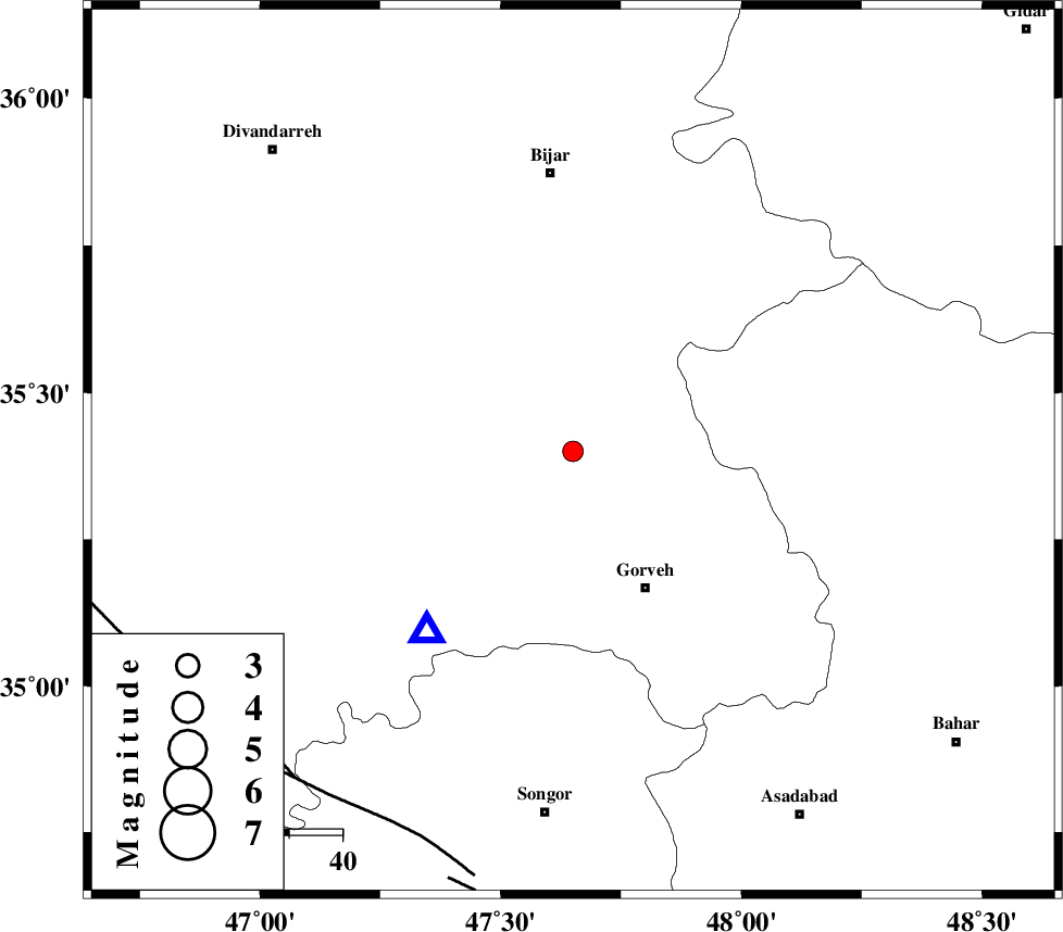
| Location | Lat:35.4 Lon: 47.65 |
| Region | 29 km North-West of Qorveh, Kordestan Province |
Nearest Cities |
|
| 14 km South of Khosroabad, Kurdistan Province | |
| 16 km North West of Serishabad, Kurdistan Province | |
| 18 km North of Kani ganji, Kurdistan Province | |
| 24 km North East of Dehgolan, Kurdistan Province | |
| 24 km North East of Hasanabad, Kurdistan Province | |
| Depth | 14 km |
| Agency | |
Faults within 150 km: |
|
| SARTAKHT_F (Length: 78 km) , Distance to epicenter: 78 km | |
| MORVARID_F (Length: 24 km) , Distance to epicenter: 81 km | |
| DINEHVAR_F (Length: 46 km) , Distance to epicenter: 84 km | |
| Number of Phases | 5 |
| RMS | 0.2 |
| Number of Stations | 3 |
| Error in Latitude | >10.1 km |
| Error in Longitude | 6.8 km |
| Error in Depth | 9.4 km |
Download waveform in seisan format
to download seisan software Click here
to access information about IIEES stations Click here
Amplitude | ||||||||
| UID | Agency | Station | Component | Amplitude | Period | Arrival Time | Proccessing Time | Signal Clip |
| 30926 | IIEES | SNGE | N | 1101.8 | 0.24 | 2004-11-13 02:42:42 | 2006-03-15 11:56:00 | n |
| 30927 | IIEES | ASAO | E | 36.7 | 0.68 | 2004-11-13 02:43:40 | 2006-03-15 11:56:00 | n |
Phase | ||||||||||||
| Agency | Station | Component | Phase Type | Phase Quality | First Motion | Observed Arrival Time | Time Residual | Loc. Flag | Input Weight | Distance | Azimuth | |
| IIEES | SNGE | Z | PG | E | 2004-11-13 02:42:36 | 0 | y | 43.6 | 219 | |||
| IIEES | SNGE | N | SG | E | 2004-11-13 02:42:42 | -0.1 | y | 43.6 | 219 | |||
| IIEES | ASAO | E | PG | E | 2004-11-13 02:43:07 | 0.2 | y | 237 | 113 | |||
| IIEES | THKV | Z | PN | E | 2004-11-13 02:43:13 | 0.1 | y | 298 | 78 | |||
| IIEES | THKV | N | SG | E | 2004-11-13 02:43:52 | -0.2 | y | 298 | 78 | |||