
Magnitude |
:2.5 |
| Date & Time (UTC) | 2004-11-12 02:12:30.7 |
| Date & Time (Local) | 1383/8/22 05:42:30.7 |
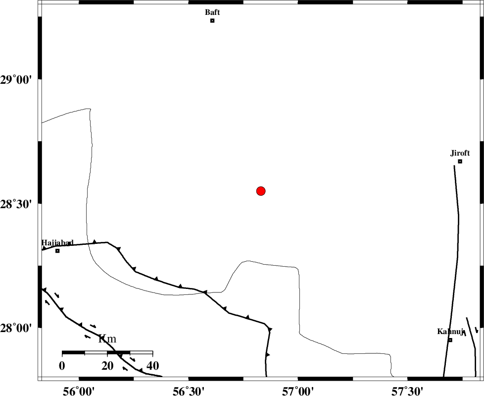
| Location | Lat:28.55 Lon: 56.83 |
| Region | 79 km South-East of Baft, Kerman Province |
Nearest Cities |
|
| 24 km North of Sarkhan, Kerman Province | |
| 31 km South West of Dolatabad, Kerman Province | |
| 45 km North East of Shahmaran, Kerman Province | |
| 47 km North East of Arzuieeh, Kerman Province | |
| 50 km South East of Kashkueyeh, Kerman Province | |
| Depth | 38 km |
| Agency | |
Faults within 150 km: |
|
| MAIN_ZAGROS_R_F (Length: 1106 km) , Distance to epicenter: 52 km | |
| SABZEVARAN_F (Length: 190 km) , Distance to epicenter: 87 km | |
| HZF2 (Length: 437 km) , Distance to epicenter: 94 km | |
| Number of Phases | 5 |
| RMS | 0.3 |
| Number of Stations | 4 |
| Error in Latitude | >4.8 km |
| Error in Longitude | 8.9 km |
| Error in Depth | 9.8 km |
Download waveform in seisan format
to download seisan software Click here
to access information about IIEES stations Click here
Amplitude | ||||||||
| UID | Agency | Station | Component | Amplitude | Period | Arrival Time | Proccessing Time | Signal Clip |
| 30908 | IIEES | BNDS | E | 80.5 | 0.43 | 2004-11-12 02:13:14 | 2006-03-15 11:56:00 | n |
| 30909 | IIEES | BNDS | N | 82.2 | 0.45 | 2004-11-12 02:13:15 | 2006-03-15 11:56:00 | n |
| 30910 | IIEES | KRBR | N | 50.2 | 0.22 | 2004-11-12 02:13:26 | 2006-03-15 11:56:00 | n |
| 30911 | IIEES | KRBR | E | 80.4 | 0.61 | 2004-11-12 02:13:27 | 2006-03-15 11:56:00 | n |
| 30912 | IIEES | GHIR | E | 8 | 0.39 | 2004-11-12 02:14:13 | 2006-03-15 11:56:00 | n |
| 30913 | IIEES | GHIR | N | 7.8 | 0.34 | 2004-11-12 02:14:27 | 2006-03-15 11:56:00 | n |
Phase | ||||||||||||
| Agency | Station | Component | Phase Type | Phase Quality | First Motion | Observed Arrival Time | Time Residual | Loc. Flag | Input Weight | Distance | Azimuth | |
| IIEES | BNDS | Z | PG | E | 2004-11-12 02:12:53 | -0.5 | y | 143 | 207 | |||
| IIEES | BNDS | E | SG | E | 2004-11-12 02:13:12 | 0.4 | y | 143 | 207 | |||
| IIEES | KRBR | Z | PG | E | 2004-11-12 02:12:57 | 0.1 | y | 159 | 358 | |||
| IIEES | GHIR | Z | PN | E | 2004-11-12 02:13:23 | 0 | y | 377 | 266 | |||
| IIEES | ZHSF | Z | PN | E | 2004-11-12 02:13:26 | 0.1 | y | 402 | 72 | |||