
Magnitude |
:2.8 |
| Date & Time (UTC) | 2004-11-11 18:11:27.2 |
| Date & Time (Local) | 1383/8/21 21:41:27.2 |
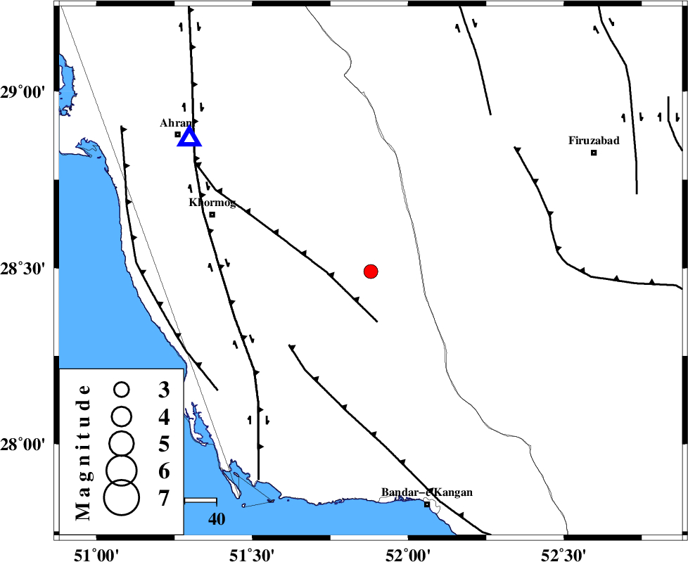
| Location | Lat:28.49 Lon: 51.88 |
| Region | 46 km South-West of Farashband, Fars Province |
Nearest Cities |
|
| 16 km North East of Shanbeh, Bushehr Province | |
| 39 km North East of Baduleh, Bushehr Province | |
| 39 km North East of Kaki, Bushehr Province | |
| 42 km West of Dahrom, Fars Province | |
| 47 km South West of Farashband, Fars Province | |
| Depth | 17 km |
| Agency | |
Faults within 150 km: |
|
| MFF5 (Length: 74 km) , Distance to epicenter: 14 km | |
| MFF3 (Length: 292 km) , Distance to epicenter: 35 km | |
| BORAZJAN_F (Length: 168 km) , Distance to epicenter: 45 km | |
| Number of Phases | 5 |
| RMS | 0.1 |
| Number of Stations | 4 |
| Error in Latitude | >12 km |
| Error in Longitude | 6.5 km |
| Error in Depth | 10 km |
Download waveform in seisan format
to download seisan software Click here
to access information about IIEES stations Click here
Amplitude | ||||||||
| UID | Agency | Station | Component | Amplitude | Period | Arrival Time | Proccessing Time | Signal Clip |
| 30886 | IIEES | GHIR | E | 361.3 | 0.36 | 2004-11-11 18:12:09 | 2006-03-15 11:56:00 | n |
| 30887 | IIEES | GHIR | N | 453.9 | 0.51 | 2004-11-11 18:12:10 | 2006-03-15 11:56:00 | n |
| 30888 | IIEES | NASN | N | 3.2 | 0.43 | 2004-11-11 18:13:27 | 2006-03-15 11:56:00 | n |
Phase | ||||||||||||
| Agency | Station | Component | Phase Type | Phase Quality | First Motion | Observed Arrival Time | Time Residual | Loc. Flag | Input Weight | Distance | Azimuth | |
| IIEES | GHIR | Z | PG | E | 2004-11-11 18:11:46 | 0 | y | 111 | 102 | |||
| IIEES | GHIR | E | SG | E | 2004-11-11 18:11:59 | 0 | y | 111 | 102 | |||
| IIEES | NASN | Z | PN | E | 2004-11-11 18:12:35 | 0.1 | y | 486 | 10 | |||
| IIEES | KRBR | Z | PN | E | 2004-11-11 18:12:37 | 0 | y | 502 | 70 | |||
| IIEES | ASAO | Z | PN | E | 2004-11-11 18:13:00 | -0.1 | y | 694 | 346 | |||