
Magnitude |
:3.4 |
| Date & Time (UTC) | 2004-11-09 02:02:25.8 |
| Date & Time (Local) | 1383/8/19 05:32:25.8 |
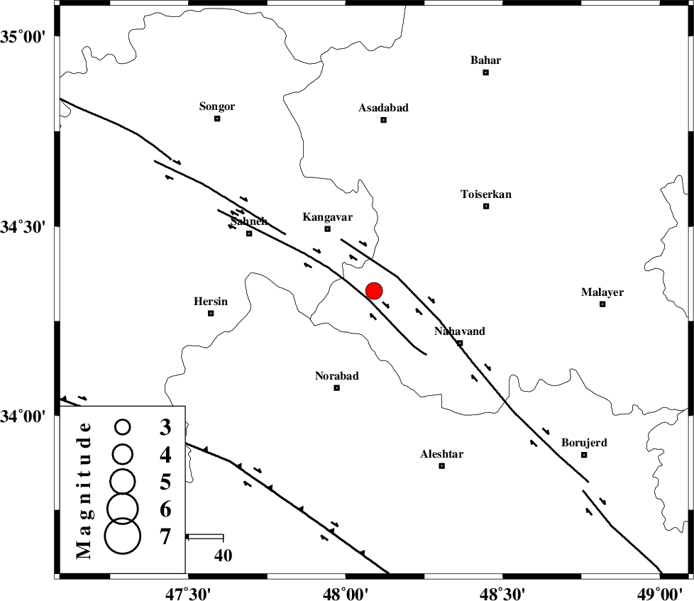
| Location | Lat:34.33 Lon: 48.09 |
| Region | 22 km South-East of Kangavar, Kermanshah Province |
Nearest Cities |
|
| 7 km of Firuzan, Hamedan Province | |
| 8 km North of Shahrak, Hamedan Province | |
| 19 km South East of Karmanjan, Kermanshah Province | |
| 20 km North West of Barzul, Hamedan Province | |
| 20 km East of Sarab dehlor, Kermanshah Province | |
| Depth | 18 km |
| Agency | |
Faults within 150 km: |
|
| SAHANEH_F (Length: 77 km) , Distance to epicenter: 3 km | |
| NAHAVAND_F (Length: 102 km) , Distance to epicenter: 8 km | |
| DINEHVAR_F (Length: 46 km) , Distance to epicenter: 31 km | |
| Number of Phases | 8 |
| RMS | 0.3 |
| Number of Stations | 5 |
| Error in Latitude | >2.7 km |
| Error in Longitude | 4.4 km |
| Error in Depth | 8.1 km |
Download waveform in seisan format
to download seisan software Click here
to access information about IIEES stations Click here
Amplitude | ||||||||
| UID | Agency | Station | Component | Amplitude | Period | Arrival Time | Proccessing Time | Signal Clip |
| 30847 | IIEES | SNGE | N | 921.5 | 0.44 | 2004-11-09 02:03:05 | 2006-03-15 11:56:00 | n |
| 30848 | IIEES | SHGR | E | 247.6 | 0.4 | 2004-11-09 02:03:42 | 2006-03-15 11:56:00 | n |
| 30849 | IIEES | SHGR | N | 173.1 | 0.44 | 2004-11-09 02:03:46 | 2006-03-15 11:56:00 | n |
| 30850 | IIEES | THKV | N | 156.9 | 0.6 | 2004-11-09 02:03:55 | 2006-03-15 11:56:00 | n |
| 30851 | IIEES | THKV | E | 122.8 | 0.48 | 2004-11-09 02:04:00 | 2006-03-15 11:56:00 | n |
Phase | ||||||||||||
| Agency | Station | Component | Phase Type | Phase Quality | First Motion | Observed Arrival Time | Time Residual | Loc. Flag | Input Weight | Distance | Azimuth | |
| IIEES | SNGE | Z | PG | E | 2004-11-09 02:02:44 | -0.2 | y | 109 | 322 | |||
| IIEES | SNGE | N | SG | E | 2004-11-09 02:02:58 | 0.2 | y | 109 | 322 | |||
| IIEES | SHGR | Z | PN | E | 2004-11-09 02:03:04 | 0.2 | y | 255 | 165 | |||
| IIEES | SHGR | E | SG | E | 2004-11-09 02:03:37 | 0.2 | y | 255 | 165 | |||
| IIEES | THKV | Z | PN | E | 2004-11-09 02:03:11 | 0 | y | 310 | 54 | |||
| IIEES | THKV | N | SG | E | 2004-11-09 02:03:53 | 0.4 | y | 310 | 54 | |||
| IIEES | DAMV | Z | PN | E | 2004-11-09 02:03:20 | -0.5 | y | 383 | 67 | |||
| IIEES | NASN | Z | PN | E | 2004-11-09 02:03:31 | -0.6 | y | 470 | 110 | |||