
Magnitude |
:2.7 |
| Date & Time (UTC) | 2004-11-08 06:34:18.6 |
| Date & Time (Local) | 1383/8/18 10:04:18.6 |
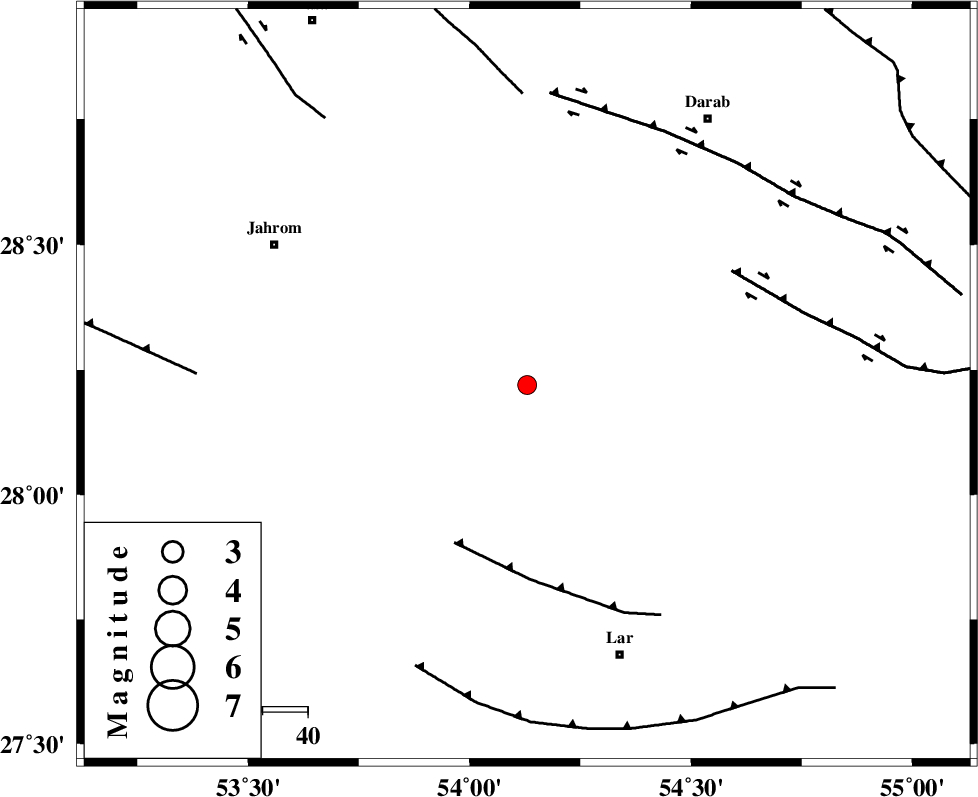
| Location | Lat:28.22 Lon: 54.13 |
| Region | 63 km North-West of Lar, Fars Province |
Nearest Cities |
|
| 22 km South of Dabiran, Fars Province | |
| 23 km West of Shahr-e pir, Fars Province | |
| 25 km North East of Juyam, Fars Province | |
| 32 km South West of Hajiabad, Fars Province | |
| 46 km North East of Kureh, Fars Province | |
| Depth | 14 km |
| Agency | |
Faults within 150 km: |
|
| BERIZ_F (Length: 49 km) , Distance to epicenter: 39 km | |
| HZF2 (Length: 437 km) , Distance to epicenter: 52 km | |
| HZF1 (Length: 102 km) , Distance to epicenter: 64 km | |
| Number of Phases | 4 |
| RMS | 0.2 |
| Number of Stations | 3 |
| Error in Latitude | >4 km |
| Error in Longitude | 2.6 km |
| Error in Depth | 7.6 km |
Download waveform in seisan format
to download seisan software Click here
to access information about IIEES stations Click here
Amplitude | ||||||||
| UID | Agency | Station | Component | Amplitude | Period | Arrival Time | Proccessing Time | Signal Clip |
| 30833 | IIEES | GHIR | E | 244 | 0.8 | 2004-11-08 06:35:02 | 2006-03-15 11:56:00 | n |
| 30834 | IIEES | GHIR | N | 249.2 | 0.44 | 2004-11-08 06:35:12 | 2006-03-15 11:56:00 | n |
| 30835 | IIEES | BNDS | E | 61.6 | 0.36 | 2004-11-08 06:35:33 | 2006-03-15 11:56:00 | n |
| 30836 | IIEES | BNDS | N | 57 | 0.56 | 2004-11-08 06:35:41 | 2006-03-15 11:56:00 | n |
Phase | ||||||||||||
| Agency | Station | Component | Phase Type | Phase Quality | First Motion | Observed Arrival Time | Time Residual | Loc. Flag | Input Weight | Distance | Azimuth | |
| IIEES | GHIR | Z | PG | E | 2004-11-08 06:34:37 | -0.1 | y | 112 | 274 | |||
| IIEES | BNDS | Z | PG | E | 2004-11-08 06:34:54 | 0 | y | 221 | 114 | |||
| IIEES | KRBR | Z | PN | E | 2004-11-08 06:35:06 | 0.3 | y | 322 | 52 | |||
| IIEES | KRBR | E | SG | E | 2004-11-08 06:35:49 | -0.1 | y | 322 | 52 | |||