
Magnitude |
:2.2 |
| Date & Time (UTC) | 2004-11-07 15:04:43.6 |
| Date & Time (Local) | 1383/8/17 18:34:43.6 |
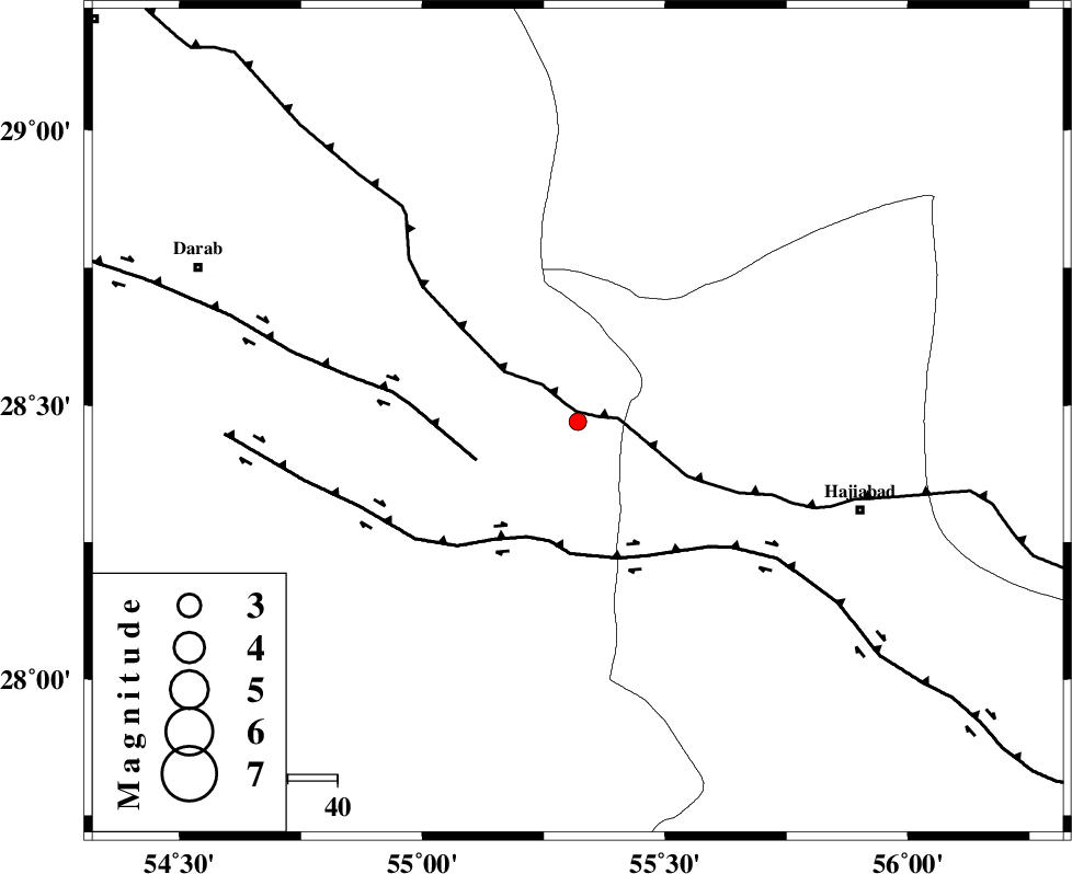
| Location | Lat:28.47 Lon: 55.32 |
| Region | 59 km North-West of Hajiabad, Hormozgan Province |
Nearest Cities |
|
| 11 km of Tal bargah, Fars Province | |
| 21 km North East of Doborji, Fars Province | |
| 24 km North East of Rostaq, Fars Province | |
| 32 km North East of Fadami, Fars Province | |
| 60 km North West of Hajiabad, Hormozgan Province | |
| Depth | 18 km |
| Agency | |
Faults within 150 km: |
|
| MAIN_ZAGROS_R_F (Length: 1106 km) , Distance to epicenter: 2 km | |
| HZF1 (Length: 102 km) , Distance to epicenter: 22 km | |
| HZF2 (Length: 437 km) , Distance to epicenter: 25 km | |
| Number of Phases | 4 |
| RMS | 0.2 |
| Number of Stations | 3 |
| Error in Latitude | >7 km |
| Error in Longitude | 5.4 km |
| Error in Depth | 59.4 km |
Download waveform in seisan format
to download seisan software Click here
to access information about IIEES stations Click here
Amplitude | ||||||||
| UID | Agency | Station | Component | Amplitude | Period | Arrival Time | Proccessing Time | Signal Clip |
| 30810 | IIEES | BNDS | E | 58.6 | 0.52 | 2004-11-07 15:05:31 | 2006-03-15 11:56:00 | n |
| 30811 | IIEES | BNDS | N | 53 | 0.32 | 2004-11-07 15:05:34 | 2006-03-15 11:56:00 | n |
| 30812 | IIEES | GHIR | E | 11.3 | 0.68 | 2004-11-07 15:06:05 | 2006-03-15 11:56:00 | n |
| 30813 | IIEES | GHIR | N | 11.7 | 0.52 | 2004-11-07 15:06:25 | 2006-03-15 11:56:00 | n |
Phase | ||||||||||||
| Agency | Station | Component | Phase Type | Phase Quality | First Motion | Observed Arrival Time | Time Residual | Loc. Flag | Input Weight | Distance | Azimuth | |
| IIEES | BNDS | Z | PG | E | 2004-11-07 15:05:07 | -0.3 | y | 145 | 145 | |||
| IIEES | BNDS | E | SG | E | 2004-11-07 15:05:25 | 0.2 | y | 145 | 145 | |||
| IIEES | KRBR | Z | PG | E | 2004-11-07 15:05:19 | 0 | y | 218 | 40 | |||
| IIEES | GHIR | Z | PG | E | 2004-11-07 15:05:21 | 0.1 | y | 230 | 265 | |||