
Magnitude |
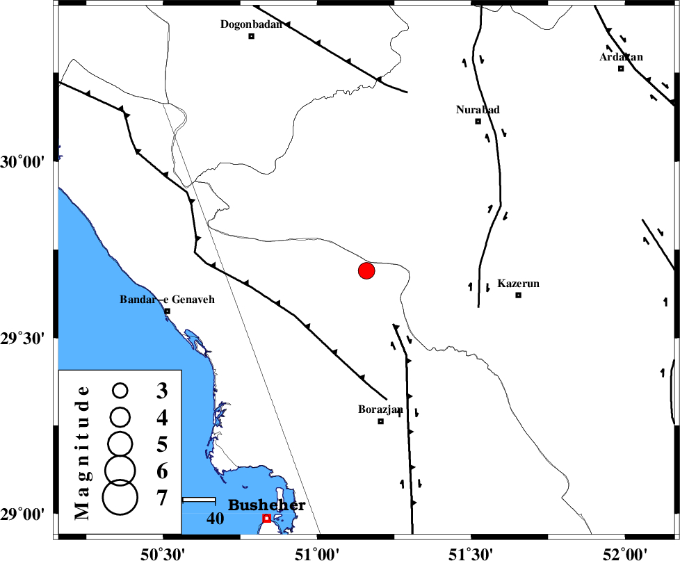
:3.4 |
| Date & Time (UTC) | 2004-11-03 23:16:18.4 |
| Date & Time (Local) | 1383/8/14 02:46:18.4 |
| Location | Lat:29.69 Lon: 51.16 |
| Region | 47 km North of Borazjan, Bushehr Province |
Nearest Cities |
|
| 22 km North West of Khesht, Fars Province | |
| 29 km North East of Dehkohneh, Bushehr Province | |
| 31 km North West of Kamaraj, Fars Province | |
| 32 km North West of Dalki, Bushehr Province | |
| 35 km North of Saedabad, Bushehr Province | |
| Depth | 15 km |
| Agency | |
Faults within 150 km: |
|
| BORAZJAN_F (Length: 168 km) , Distance to epicenter: 19 km | |
| ZFF3 (Length: 125 km) , Distance to epicenter: 27 km | |
| KAZERUN_F (Length: 96 km) , Distance to epicenter: 36 km | |
| Number of Phases | 4 |
| RMS | 0.2 |
| Number of Stations | 4 |
| Error in Latitude | >14.5 km |
| Error in Longitude | 2.7 km |
| Error in Depth | 0 km |
Download waveform in seisan format
to download seisan software Click here
to access information about IIEES stations Click here
Amplitude | ||||||||
| UID | Agency | Station | Component | Amplitude | Period | Arrival Time | Proccessing Time | Signal Clip |
| 30752 | IIEES | SHGR | E | 173.3 | 0.6 | 2004-11-03 23:18:14 | 2006-03-15 11:56:00 | n |
| 30753 | IIEES | SHGR | Z | 95.3 | 0.64 | 2004-11-03 23:18:44 | 2006-03-15 11:56:00 | n |
| 30754 | IIEES | KRBR | N | 18.1 | 0.72 | 2004-11-03 23:18:33 | 2006-03-15 11:56:00 | n |
| 30755 | IIEES | KRBR | E | 25.5 | 0.72 | 2004-11-03 23:18:39 | 2006-03-15 11:56:00 | n |
| 30756 | IIEES | SNGE | N | 16.1 | 0.53 | 2004-11-03 23:19:15 | 2006-03-15 11:56:00 | n |
Phase | ||||||||||||
| Agency | Station | Component | Phase Type | Phase Quality | First Motion | Observed Arrival Time | Time Residual | Loc. Flag | Input Weight | Distance | Azimuth | |
| IIEES | SHGR | Z | PN | E | 2004-11-03 23:17:09 | 0.2 | y | 351 | 321 | |||
| IIEES | KRBR | Z | PN | E | 2004-11-03 23:17:33 | 0 | y | 542 | 85 | |||
| IIEES | DAMV | Z | PN | E | 2004-11-03 23:17:48 | 0.1 | y | 663 | 6 | |||
| IIEES | SNGE | Z | PN | E | 2004-11-03 23:17:52 | -0.5 | y | 699 | 330 | |||