
Magnitude |
:3.6 |
| Date & Time (UTC) | 2004-10-23 18:16:47.0 |
| Date & Time (Local) | 1383/8/2 21:46:47.0 |
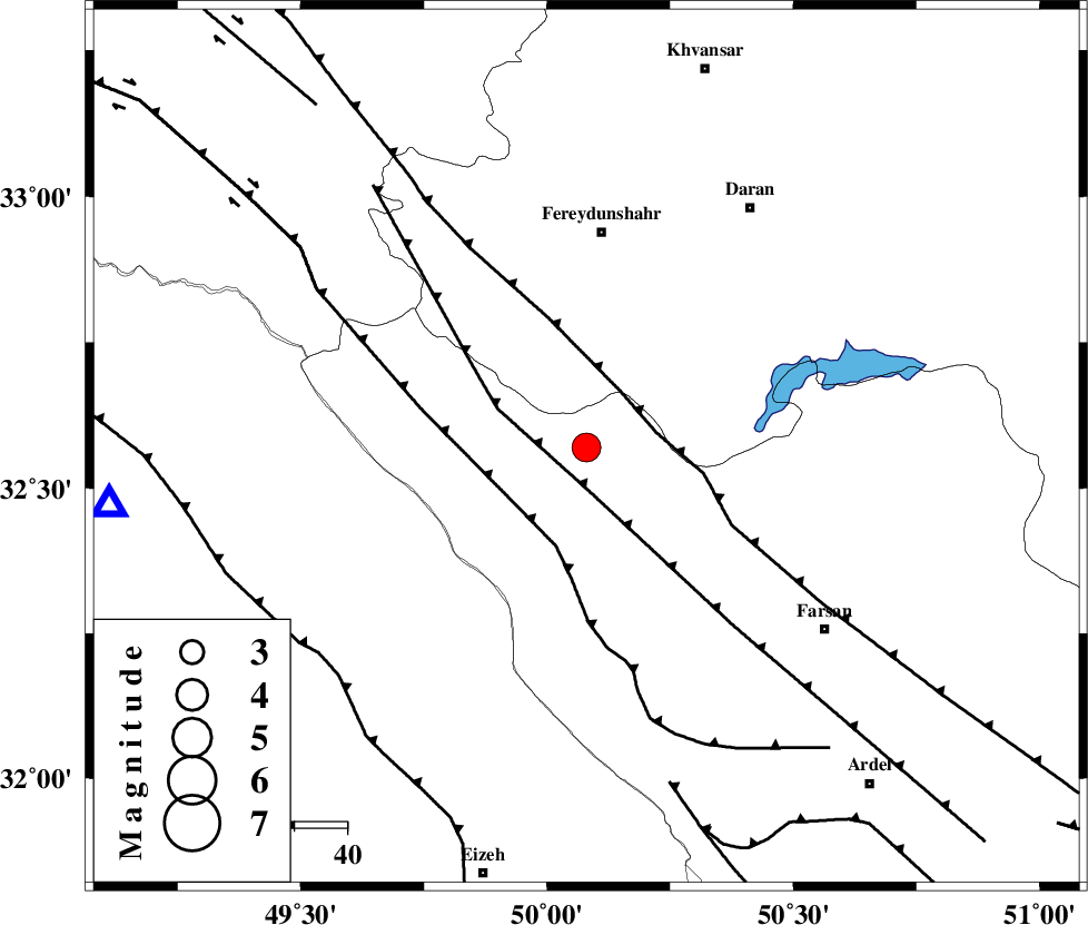
| Location | Lat:32.57 Lon: 50.08 |
| Region | 11 km North of Chelgard, Chaharmahal Bakhtiari Province |
Nearest Cities |
|
| 12 km North of Chelgard, Chaharmahal Bakhtiari Province | |
| 19 km North West of Kukanak, Esfahan Province | |
| 23 km South West of Ghale? sorkh, Esfahan Province | |
| 25 km South East of Durak, Chaharmahal Bakhtiari Province | |
| 33 km West of Organ, Esfahan Province | |
| Depth | 15 km |
| Agency | |
Faults within 150 km: |
|
| ARDAL_F (Length: 170 km) , Distance to epicenter: 8 km | |
| MAIN_ZAGROS_R_F (Length: 1106 km) , Distance to epicenter: 13 km | |
| ZARDKUH_F (Length: 139 km) , Distance to epicenter: 20 km | |
| Number of Phases | 6 |
| RMS | 0.5 |
| Number of Stations | 4 |
| Error in Latitude | >12.2 km |
| Error in Longitude | 5.9 km |
| Error in Depth | 15.3 km |
Download waveform in seisan format
to download seisan software Click here
to access information about IIEES stations Click here
Amplitude | ||||||||
| UID | Agency | Station | Component | Amplitude | Period | Arrival Time | Proccessing Time | Signal Clip |
| 30625 | IIEES | SHGR | E | 2196.4 | 0.43 | 2004-10-23 18:17:28 | 2006-03-15 11:56:00 | n |
| 30626 | IIEES | SHGR | N | 1483.6 | 1 | 2004-10-23 18:17:32 | 2006-03-15 11:56:00 | n |
| 30627 | IIEES | NASN | N | 198.3 | 0.49 | 2004-10-23 18:18:06 | 2006-03-15 11:56:00 | n |
| 30628 | IIEES | NASN | E | 230.7 | 0.68 | 2004-10-23 18:18:07 | 2006-03-15 11:56:00 | n |
Phase | ||||||||||||
| Agency | Station | Component | Phase Type | Phase Quality | First Motion | Observed Arrival Time | Time Residual | Loc. Flag | Input Weight | Distance | Azimuth | |
| IIEES | SHGR | Z | PG | E | 2004-10-23 18:17:08 | -0.4 | y | 131 | 247 | |||
| IIEES | SHGR | N | SG | E | 2004-10-23 18:17:25 | 0.4 | y | 131 | 247 | |||
| IIEES | NASN | Z | PN | E | 2004-10-23 18:17:27 | 0.8 | y | 257 | 84 | |||
| IIEES | NASN | N | SG | E | 2004-10-23 18:17:59 | 0 | y | 257 | 84 | |||
| IIEES | DAMV | Z | PN | E | 2004-10-23 18:17:41 | -0.4 | y | 382 | 27 | |||
| IIEES | GHIR | Z | PN | E | 2004-10-23 18:18:02 | -0.7 | y | 550 | 149 | |||