
Magnitude |
:2 |
| Date & Time (UTC) | 2004-10-21 03:41:46.8 |
| Date & Time (Local) | 1383/7/30 07:11:46.8 |
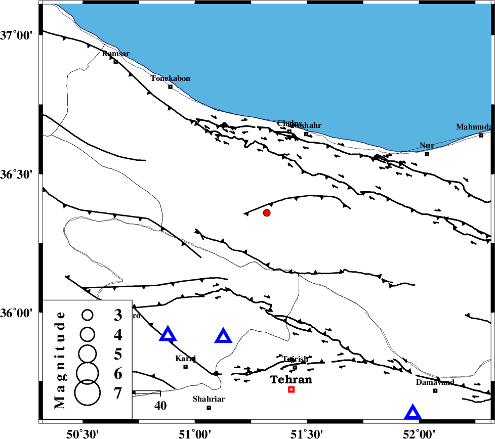
| Location | Lat:36.36 Lon: 51.32 |
| Region | 33 km South of Chalus, Mazandaran Province |
Nearest Cities |
|
| 6 km of Tavir, Mazandaran Province | |
| 10 km of Marzanabad, Mazandaran Province | |
| 15 km South of Goyter, Mazandaran Province | |
| 16 km North of Pol-e zanguleh, Mazandaran Province | |
| 20 km South of Kardichal, Mazandaran Province | |
| Depth | 45 km |
| Agency | |
Faults within 150 km: |
|
| KOJOOR (Length: 75 km) , Distance to epicenter: 9 km | |
| KANDOVAN_F (Length: 90 km) , Distance to epicenter: 19 km | |
| N_ALBORZ_F (Length: 360 km) , Distance to epicenter: 23 km | |
| Number of Phases | 5 |
| RMS | 0 |
| Number of Stations | 3 |
| Error in Latitude | >5.1 km |
| Error in Longitude | 1.9 km |
| Error in Depth | 4.4 km |
Download waveform in seisan format
to download seisan software Click here
to access information about IIEES stations Click here
Amplitude | ||||||||
| UID | Agency | Station | Component | Amplitude | Period | Arrival Time | Proccessing Time | Signal Clip |
| 30619 | IIEES | THKV | E | 92.4 | 0.45 | 2004-10-21 03:42:10 | 2006-03-15 11:56:00 | n |
| 30620 | IIEES | THKV | N | 135.1 | 0.36 | 2004-10-21 03:42:10 | 2006-03-15 11:56:00 | n |
| 30621 | IIEES | DAMV | E | 27.1 | 0.26 | 2004-10-21 03:42:18 | 2006-03-15 11:56:00 | n |
| 30622 | IIEES | DAMV | N | 26.7 | 0.3 | 2004-10-21 03:42:18 | 2006-03-15 11:56:00 | n |
| 30623 | IIEES | ASAO | E | 7.1 | 0.4 | 2004-10-21 03:42:56 | 2006-03-15 11:56:00 | n |
| 30624 | IIEES | ASAO | N | 12.3 | 0.48 | 2004-10-21 03:42:57 | 2006-03-15 11:56:00 | n |
Phase | ||||||||||||
| Agency | Station | Component | Phase Type | Phase Quality | First Motion | Observed Arrival Time | Time Residual | Loc. Flag | Input Weight | Distance | Azimuth | |
| IIEES | THKV | Z | PG | E | 2004-10-21 03:41:59 | 0 | y | 63.3 | 219 | |||
| IIEES | THKV | E | SG | E | 2004-10-21 03:42:08 | 0 | y | 63.3 | 219 | |||
| IIEES | DAMV | Z | PG | E | 2004-10-21 03:42:04 | 0 | y | 99.7 | 144 | |||
| IIEES | DAMV | N | SG | E | 2004-10-21 03:42:17 | 0 | y | 99.7 | 144 | |||
| IIEES | ASAO | Z | PG | E | 2004-10-21 03:42:24 | 0 | y | 233 | 211 | |||