
Magnitude |
:5.1 |
| Date & Time (UTC) | 2004-10-16 10:04:33.9 |
| Date & Time (Local) | 1383/7/25 13:34:33.9 |
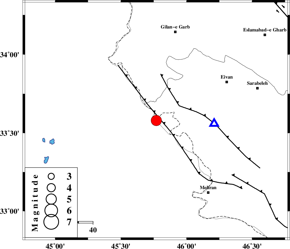
| Location | Lat:33.58 Lon: 45.77 |
| Region | 56 km South-West of Eyvan, Ilam Province |
Nearest Cities |
|
| 35 km South East of Sumar, Kermanshah Province | |
| 40 km North West of Salehabad, Ilam Province | |
| 48 km South West of Chavar, Ilam Province | |
| 53 km South West of Teran, Ilam Province | |
| 53 km South West of Nian, Kermanshah Province | |
| Depth | 18 km |
| Agency | |
Faults within 150 km: |
|
| ZFF4 (Length: 128 km) , Distance to epicenter: 12 km | |
| MFF7 (Length: 99 km) , Distance to epicenter: 19 km | |
| MFF6 (Length: 144 km) , Distance to epicenter: 66 km | |
| Number of Phases | 5 |
| RMS | 0.3 |
| Number of Stations | 3 |
| Error in Latitude | >5 km |
| Error in Longitude | 15.7 km |
| Error in Depth | 14 km |
Download waveform in seisan format
to download seisan software Click here
to access information about IIEES stations Click here
Amplitude | ||||||||
| UID | Agency | Station | Component | Amplitude | Period | Arrival Time | Proccessing Time | Signal Clip |
| 30564 | IIEES | SNGE | N | 8746 | 0.64 | 2004-10-16 10:05:50 | 2006-03-15 11:56:00 | n |
| 30565 | IIEES | SHGR | N | 10189.6 | 0.48 | 2004-10-16 10:06:13 | 2006-03-15 11:56:00 | n |
| 30566 | IIEES | SHGR | E | 9352.6 | 0.32 | 2004-10-16 10:06:26 | 2006-03-15 11:56:00 | n |
| 30567 | IIEES | ASAO | E | 2020.7 | 0.57 | 2004-10-16 10:06:38 | 2006-03-15 11:56:00 | n |
| 30568 | IIEES | ASAO | N | 3112.9 | 0.57 | 2004-10-16 10:06:40 | 2006-03-15 11:56:00 | n |
Phase | ||||||||||||
| Agency | Station | Component | Phase Type | Phase Quality | First Motion | Observed Arrival Time | Time Residual | Loc. Flag | Input Weight | Distance | Azimuth | |
| IIEES | SNGE | Z | PG | E | 2004-10-16 10:05:10 | 0.1 | y | 222 | 40 | |||
| IIEES | SNGE | N | SG | E | 2004-10-16 10:05:36 | -0.2 | y | 222 | 40 | |||
| IIEES | SHGR | Z | PN | E | 2004-10-16 10:05:21 | -0.4 | y | 327 | 119 | |||
| IIEES | SHGR | N | SG | E | 2004-10-16 10:06:05 | 0.1 | y | 327 | 119 | |||
| IIEES | ASAO | Z | PN | E | 2004-10-16 10:05:32 | 0.4 | y | 407 | 73 | |||