
Magnitude |
:2.8 |
| Date & Time (UTC) | 2004-10-12 22:00:54.0 |
| Date & Time (Local) | 1383/7/22 01:30:54.0 |
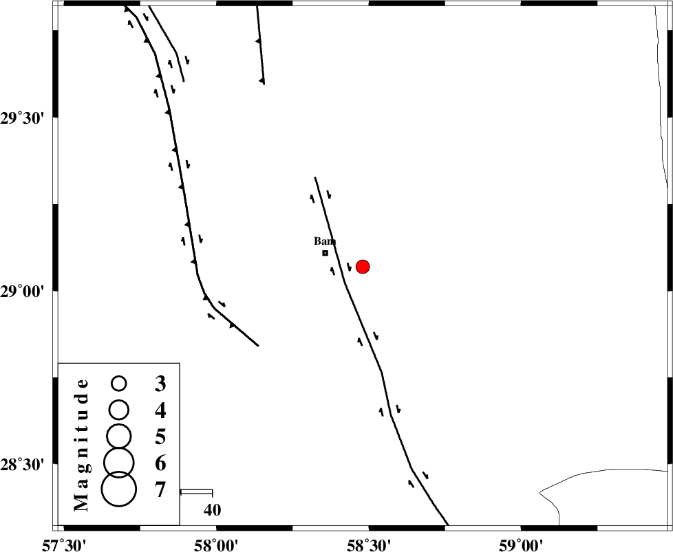
| Location | Lat:29.07 Lon: 58.48 |
| Region | 12 km East of Bam, Kerman Province |
Nearest Cities |
|
| 8 km North of Baravat, Kerman Province | |
| 11 km of Poshtrud, Kerman Province | |
| 13 km East of Bam, Kerman Province | |
| 19 km North of Abshur-e nezamabad, Kerman Province | |
| 20 km North West of Qasemabad, Kerman Province | |
| Depth | 14 km |
| Agency | |
Faults within 150 km: |
|
| BAM_F (Length: 118 km) , Distance to epicenter: 8 km | |
| GOWK_F (Length: 152 km) , Distance to epicenter: 42 km | |
| SHAHDAD_F (Length: 108 km) , Distance to epicenter: 66 km | |
| Number of Phases | 4 |
| RMS | 0.2 |
| Number of Stations | 3 |
| Error in Latitude | >26.8 km |
| Error in Longitude | 7.8 km |
| Error in Depth | 47.9 km |
Download waveform in seisan format
to download seisan software Click here
to access information about IIEES stations Click here
Amplitude | ||||||||
| UID | Agency | Station | Component | Amplitude | Period | Arrival Time | Proccessing Time | Signal Clip |
| 30503 | IIEES | KRBR | N | 175.1 | 0.2 | 2004-10-12 22:01:52 | 2006-03-15 11:56:00 | n |
| 30504 | IIEES | KRBR | E | 159.6 | 0.1 | 2004-10-12 22:01:53 | 2006-03-15 11:56:00 | n |
| 30505 | IIEES | ZHSF | N | 38.2 | 0.52 | 2004-10-12 22:02:04 | 2006-03-15 11:56:00 | n |
| 30506 | IIEES | ZHSF | E | 51.3 | 0.4 | 2004-10-12 22:02:04 | 2006-03-15 11:56:00 | n |
Phase | ||||||||||||
| Agency | Station | Component | Phase Type | Phase Quality | First Motion | Observed Arrival Time | Time Residual | Loc. Flag | Input Weight | Distance | Azimuth | |
| IIEES | KRBR | Z | PG | E | 2004-10-12 22:01:25 | -0.3 | y | 195 | 302 | |||
| IIEES | KRBR | N | SG | E | 2004-10-12 22:01:49 | 0.2 | y | 195 | 302 | |||
| IIEES | ZHSF | Z | PG | E | 2004-10-12 22:01:32 | 0.1 | y | 231 | 74 | |||
| IIEES | BNDS | Z | PN | E | 2004-10-12 22:01:38 | 0 | y | 292 | 231 | |||