
Magnitude |
:2.4 |
| Date & Time (UTC) | 2004-10-05 12:10:51.2 |
| Date & Time (Local) | 1383/7/14 15:40:51.2 |
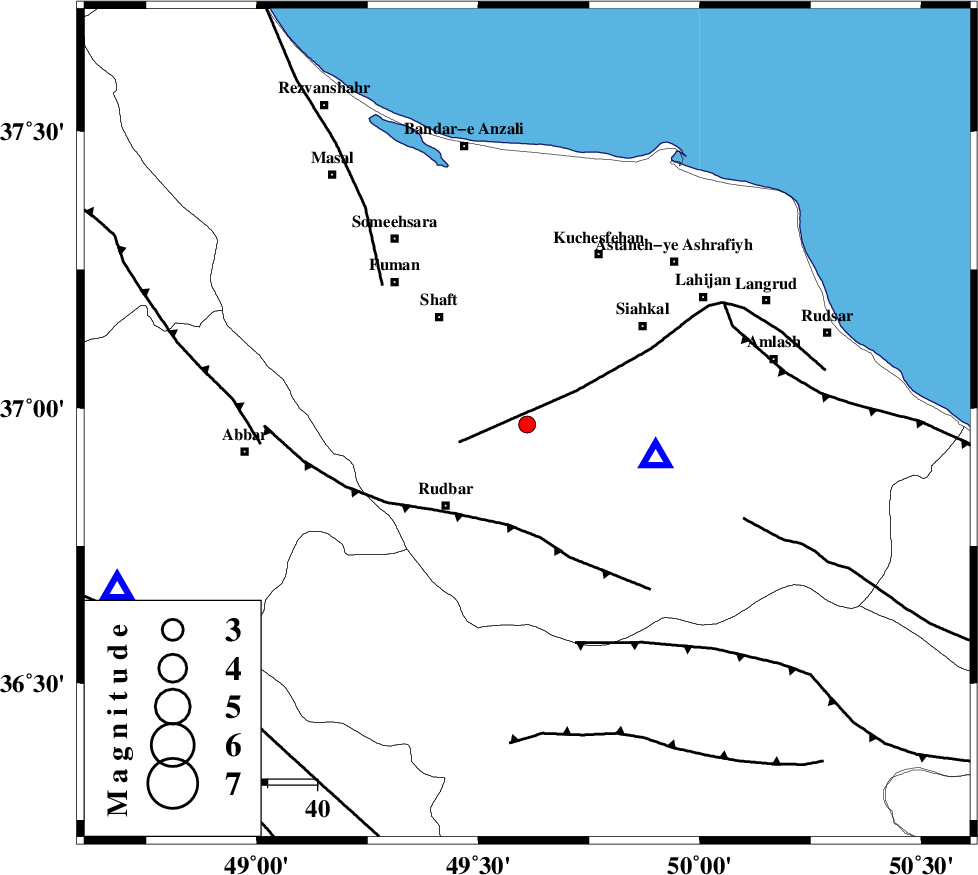
| Location | Lat:36.97 Lon: 49.61 |
| Region | 23 km North-East of Rudbar, Gilan Province |
Nearest Cities |
|
| 6 km of Shahr-e bijar, Gilan Province | |
| 9 km of Eskolak, Gilan Province | |
| 10 km East of Nasir mahalleh, Gilan Province | |
| 13 km South of Saravan, Gilan Province | |
| 13 km North of Dashtvil, Gilan Province | |
| Depth | 14 km |
| Agency | |
Faults within 150 km: |
|
| LAHIJAN_F (Length: 92 km) , Distance to epicenter: 12 km | |
| RUDBAR_F (Length: 93 km) , Distance to epicenter: 21 km | |
| TALESH_F (Length: 258 km) , Distance to epicenter: 40 km | |
| Number of Phases | 6 |
| RMS | 0.2 |
| Number of Stations | 4 |
| Error in Latitude | >7.6 km |
| Error in Longitude | 11.6 km |
| Error in Depth | 7.7 km |
Download waveform in seisan format
to download seisan software Click here
to access information about IIEES stations Click here
Amplitude | ||||||||
| UID | Agency | Station | Component | Amplitude | Period | Arrival Time | Proccessing Time | Signal Clip |
| 30390 | IIEES | THKV | E | 74.6 | 0.29 | 2004-10-05 12:11:38 | 2006-03-15 11:56:00 | n |
| 30391 | IIEES | THKV | N | 61.6 | 0.14 | 2004-10-05 12:11:39 | 2006-03-15 11:56:00 | n |
| 30392 | IIEES | ASAO | N | 12.2 | 0.28 | 2004-10-05 12:12:05 | 2006-03-15 11:56:00 | n |
| 30393 | IIEES | ASAO | E | 13.1 | 0.48 | 2004-10-05 12:12:06 | 2006-03-15 11:56:00 | n |
Phase | ||||||||||||
| Agency | Station | Component | Phase Type | Phase Quality | First Motion | Observed Arrival Time | Time Residual | Loc. Flag | Input Weight | Distance | Azimuth | |
| IIEES | THKV | Z | PG | E | 2004-10-05 12:11:18 | 0 | y | 163 | 135 | |||
| IIEES | THKV | E | SG | E | 2004-10-05 12:11:37 | -0.3 | y | 163 | 135 | |||
| IIEES | GRMI | Z | PN | E | 2004-10-05 12:11:30 | 0.1 | y | 254 | 324 | |||
| IIEES | GRMI | N | SG | E | 2004-10-05 12:12:02 | -0.2 | y | 254 | 324 | |||
| IIEES | DAMV | Z | PN | E | 2004-10-05 12:11:31 | 0.4 | y | 259 | 124 | |||
| IIEES | ASAO | Z | PN | E | 2004-10-05 12:11:32 | 0 | y | 271 | 172 | |||