
Magnitude |
:3.2 |
| Date & Time (UTC) | 2004-09-30 02:07:26.8 |
| Date & Time (Local) | 1383/7/9 05:37:26.8 |
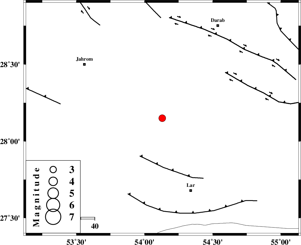
| Location | Lat:28.15 Lon: 54.13 |
| Region | 56 km North-West of Lar, Fars Province |
Nearest Cities |
|
| 25 km East of Juyam, Fars Province | |
| 28 km South West of Shahr-e pir, Fars Province | |
| 29 km South of Dabiran, Fars Province | |
| 37 km South West of Hajiabad, Fars Province | |
| 41 km North East of Kureh, Fars Province | |
| Depth | 14 km |
| Agency | |
Faults within 150 km: |
|
| BERIZ_F (Length: 49 km) , Distance to epicenter: 32 km | |
| HZF2 (Length: 437 km) , Distance to epicenter: 56 km | |
| LAR_F (Length: 99 km) , Distance to epicenter: 60 km | |
| Number of Phases | 5 |
| RMS | 0.4 |
| Number of Stations | 4 |
| Error in Latitude | >18.2 km |
| Error in Longitude | 8.1 km |
| Error in Depth | 11.4 km |
Download waveform in seisan format
to download seisan software Click here
to access information about IIEES stations Click here
Amplitude | ||||||||
| UID | Agency | Station | Component | Amplitude | Period | Arrival Time | Proccessing Time | Signal Clip |
| 28224 | IIEES | GHIR | E | 902 | 0.49 | 2004-09-30 02:08:11 | 2006-03-15 11:56:00 | n |
| 28225 | IIEES | GHIR | N | 779.7 | 0.6 | 2004-09-30 02:08:15 | 2006-03-15 11:56:00 | n |
| 28226 | IIEES | KRBR | N | 58.4 | 0.4 | 2004-09-30 02:09:14 | 2006-03-15 11:56:00 | n |
| 28227 | IIEES | KRBR | E | 68.3 | 0.52 | 2004-09-30 02:09:16 | 2006-03-15 11:56:00 | n |
Phase | ||||||||||||
| Agency | Station | Component | Phase Type | Phase Quality | First Motion | Observed Arrival Time | Time Residual | Loc. Flag | Input Weight | Distance | Azimuth | |
| IIEES | GHIR | Z | PG | E | 2004-09-30 02:07:45 | -0.3 | y | 113 | 278 | |||
| IIEES | KRBR | Z | PN | E | 2004-09-30 02:08:15 | 0.3 | y | 327 | 51 | |||
| IIEES | KRBR | N | SG | E | 2004-09-30 02:08:58 | -0.4 | y | 327 | 51 | |||
| IIEES | NASN | Z | PN | E | 2004-09-30 02:08:41 | 0.6 | y | 531 | 346 | |||
| IIEES | ASAO | Z | PN | E | 2004-09-30 02:09:15 | -0.1 | y | 810 | 332 | |||