
Magnitude |
:3.8 |
| Date & Time (UTC) | 2004-09-27 19:07:02.8 |
| Date & Time (Local) | 1383/7/6 22:37:02.8 |
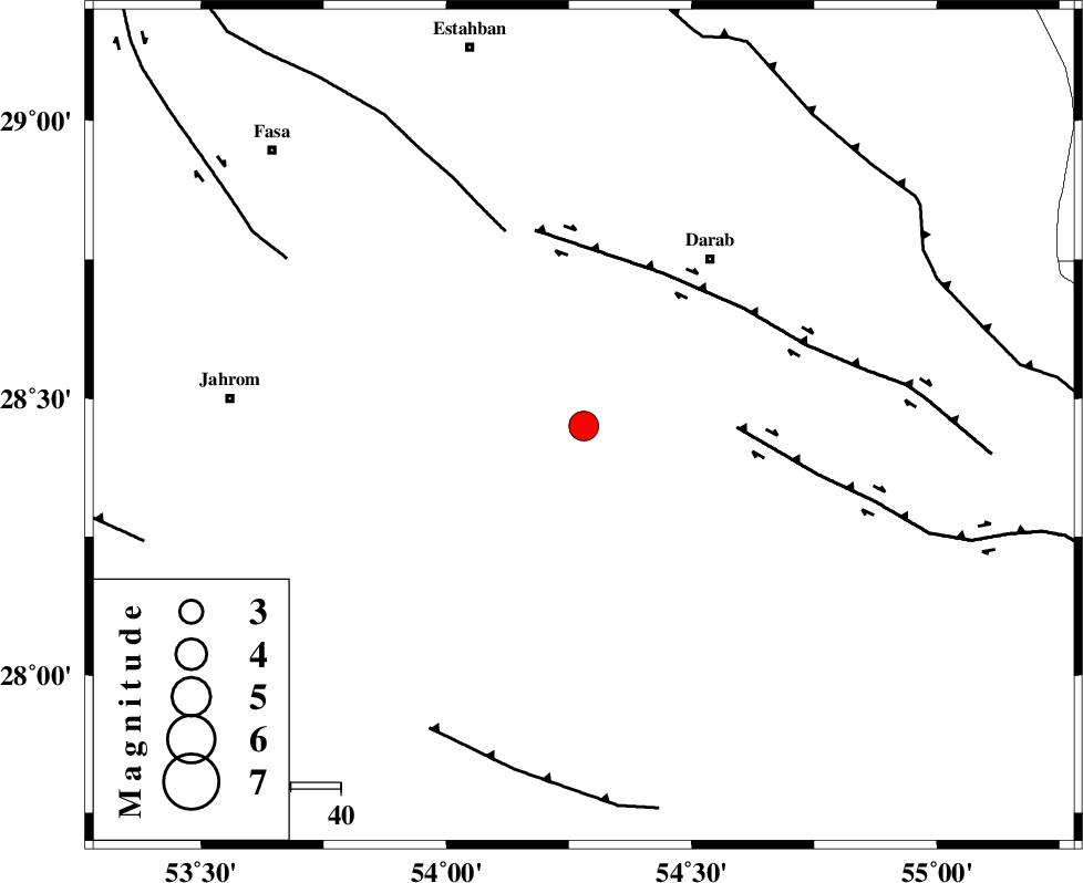
| Location | Lat:28.45 Lon: 54.28 |
| Region | 42 km South-West of Darab, Fars Province |
Nearest Cities |
|
| 9 km North of Dabiran, Fars Province | |
| 16 km North of Shahr-e pir, Fars Province | |
| 17 km North West of Hajiabad, Fars Province | |
| 27 km South West of Nasrovan, Fars Province | |
| 34 km South of Madoan, Fars Province | |
| Depth | 14 km |
| Agency | |
Faults within 150 km: |
|
| HZF2 (Length: 437 km) , Distance to epicenter: 31 km | |
| HZF1 (Length: 102 km) , Distance to epicenter: 34 km | |
| BAKHTEGAN_F (Length: 94 km) , Distance to epicenter: 42 km | |
| Number of Phases | 6 |
| RMS | 0.2 |
| Number of Stations | 5 |
| Error in Latitude | >6.4 km |
| Error in Longitude | 3.3 km |
| Error in Depth | 5.4 km |
Download waveform in seisan format
to download seisan software Click here
to access information about IIEES stations Click here
Amplitude | ||||||||
| UID | Agency | Station | Component | Amplitude | Period | Arrival Time | Proccessing Time | Signal Clip |
| 28199 | IIEES | GHIR | N | 1718.3 | 0.56 | 2004-09-27 19:07:48 | 2006-03-15 11:56:00 | n |
| 28200 | IIEES | GHIR | E | 1814.4 | 0.48 | 2004-09-27 19:07:50 | 2006-03-15 11:56:00 | n |
| 28201 | IIEES | KRBR | E | 356 | 0.8 | 2004-09-27 19:08:38 | 2006-03-15 11:56:00 | n |
| 28202 | IIEES | KRBR | N | 425.4 | 0.6 | 2004-09-27 19:08:43 | 2006-03-15 11:56:00 | n |
Phase | ||||||||||||
| Agency | Station | Component | Phase Type | Phase Quality | First Motion | Observed Arrival Time | Time Residual | Loc. Flag | Input Weight | Distance | Azimuth | |
| IIEES | GHIR | Z | PG | E | 2004-09-27 19:07:24 | 0 | y | 128 | 262 | |||
| IIEES | KRBR | Z | PN | E | 2004-09-27 19:07:47 | 0.1 | y | 295 | 54 | |||
| IIEES | KRBR | E | SG | E | 2004-09-27 19:08:26 | -0.1 | y | 295 | 54 | |||
| IIEES | NASN | Z | PN | E | 2004-09-27 19:08:13 | 0.3 | y | 502 | 344 | |||
| IIEES | ASAO | Z | PN | E | 2004-09-27 19:08:48 | -0.2 | y | 787 | 330 | |||
| IIEES | DAMV | Z | PN | E | 2004-09-27 19:08:53 | -0.1 | y | 825 | 345 | |||