
Magnitude |
:2.4 |
| Date & Time (UTC) | 2004-08-25 17:18:37.3 |
| Date & Time (Local) | 1383/6/4 21:48:37.3 |
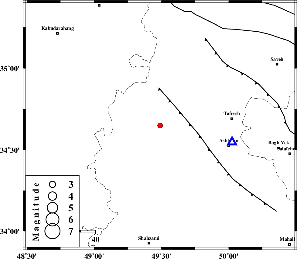
| Location | Lat:34.65 Lon: 49.49 |
| Region | 49 km North-West of Ashtiyan, Markazi Province |
Nearest Cities |
|
| 12 km South of Khanjin, Markazi Province | |
| 14 km North East of Safandan, Markazi Province | |
| 21 km South East of Komijan, Markazi Province | |
| 23 km West of Fashak, Markazi Province | |
| 24 km East of Khosrobeyk, Markazi Province | |
| Depth | 46 km |
| Agency | |
Faults within 150 km: |
|
| TAFRESH_F (Length: 117 km) , Distance to epicenter: 16 km | |
| INDES_F (Length: 98 km) , Distance to epicenter: 61 km | |
| KUSHK_E_NOSRAT_F (Length: 230 km) , Distance to epicenter: 78 km | |
| Number of Phases | 4 |
| RMS | 0.1 |
| Number of Stations | 3 |
| Error in Latitude | >7.3 km |
| Error in Longitude | 10.3 km |
| Error in Depth | 9 km |
Download waveform in seisan format
to download seisan software Click here
to access information about IIEES stations Click here
Amplitude | ||||||||
| UID | Agency | Station | Component | Amplitude | Period | Arrival Time | Proccessing Time | Signal Clip |
| 28187 | IIEES | THKV | E | 58.6 | 0.28 | 2004-08-25 17:19:33 | 2006-03-15 11:56:00 | n |
| 28188 | IIEES | THKV | N | 47.6 | 0.44 | 2004-08-25 17:19:37 | 2006-03-15 11:56:00 | n |
| 28189 | IIEES | DAMV | N | 14.2 | 0.21 | 2004-08-25 17:19:55 | 2006-03-15 11:56:00 | n |
Phase | ||||||||||||
| Agency | Station | Component | Phase Type | Phase Quality | First Motion | Observed Arrival Time | Time Residual | Loc. Flag | Input Weight | Distance | Azimuth | |
| IIEES | ASAO | Z | PG | I | 2004-08-25 17:18:48 | 0 | y | 50.8 | 103 | |||
| IIEES | ASAO | E | SG | E | 2004-08-25 17:18:56 | 0 | y | 50.8 | 103 | |||
| IIEES | THKV | Z | PG | E | 2004-08-25 17:19:08 | 0.1 | y | 189 | 42 | |||
| IIEES | DAMV | Z | PG | E | 2004-08-25 17:19:17 | -0.1 | y | 251 | 64 | |||