
Magnitude |
:3.8 |
| Date & Time (UTC) | 2004-07-20 03:21:09.7 |
| Date & Time (Local) | 1383/4/30 07:51:09.7 |
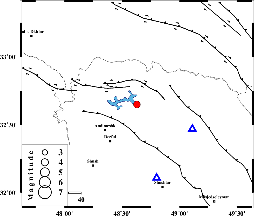
| Location | Lat:32.65 Lon: 48.63 |
| Region | 33 km North-East of Andimeshk, Khoozestan Province |
Nearest Cities |
|
| 23 km South West of Shuy, Khoozestan Province | |
| 26 km North West of Sardasht, Khoozestan Province | |
| 29 km North of Mahur berenji, Khoozestan Province | |
| 31 km South East of Sorkhakan, Khoozestan Province | |
| 34 km North East of Andimeshk, Khoozestan Province | |
| Depth | 14 km |
| Agency | |
Faults within 150 km: |
|
| BALARUD_F_Z3 (Length: 53 km) , Distance to epicenter: 16 km | |
| BALARUD_F_Z2 (Length: 58 km) , Distance to epicenter: 17 km | |
| DEZFUL_EMBAYMENT (Length: 228 km) , Distance to epicenter: 20 km | |
| Number of Phases | 5 |
| RMS | 0.3 |
| Number of Stations | 3 |
| Error in Latitude | >7.4 km |
| Error in Longitude | 30.7 km |
| Error in Depth | 30.8 km |
Download waveform in seisan format
to download seisan software Click here
to access information about IIEES stations Click here
Amplitude | ||||||||
| UID | Agency | Station | Component | Amplitude | Period | Arrival Time | Proccessing Time | Signal Clip |
| 28148 | IIEES | THKV | N | 109 | 0.64 | 2004-07-20 03:23:14 | 2006-03-15 11:56:00 | n |
| 28149 | IIEES | DAMV | N | 114.5 | 0.68 | 2004-07-20 03:23:21 | 2006-03-15 11:56:00 | n |
| 28150 | IIEES | GHIR | N | 48.5 | 0.36 | 2004-07-20 03:23:44 | 2006-03-15 11:56:00 | n |
Phase | ||||||||||||
| Agency | Station | Component | Phase Type | Phase Quality | First Motion | Observed Arrival Time | Time Residual | Loc. Flag | Input Weight | Distance | Azimuth | |
| IIEES | THKV | Z | PN | E | 2004-07-20 03:22:09 | 0.4 | y | 417 | 29 | |||
| IIEES | THKV | N | SG | E | 2004-07-20 03:23:05 | -0.4 | y | 417 | 29 | |||
| IIEES | DAMV | Z | PN | E | 2004-07-20 03:22:13 | -0.2 | y | 452 | 42 | |||
| IIEES | DAMV | E | SG | E | 2004-07-20 03:23:16 | 0.3 | y | 452 | 42 | |||
| IIEES | GHIR | Z | PN | E | 2004-07-20 03:22:36 | -0.2 | y | 640 | 138 | |||