
Magnitude |
:3.1 |
| Date & Time (UTC) | 2004-08-17 07:35:00.5 |
| Date & Time (Local) | 1383/5/27 12:05:00.5 |
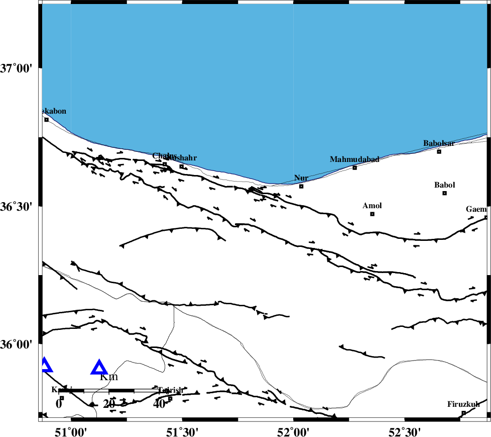
| Location | Lat:36.48 Lon: 51.87 |
| Region | 17 km West of Nur, Mazandaran Province |
Nearest Cities |
|
| 6 km of Narenj bon, Mazandaran Province | |
| 17 km North East of Kujur, Mazandaran Province | |
| 18 km West of Nur, Mazandaran Province | |
| 19 km South East of Andarud, Mazandaran Province | |
| 22 km North West of Chamestan, Mazandaran Province | |
| Depth | 6 km |
| Agency | |
Faults within 150 km: |
|
| KHAZAR_F (Length: 523 km) , Distance to epicenter: 6 km | |
| N_ALBORZ_F (Length: 360 km) , Distance to epicenter: 7 km | |
| KOJOOR (Length: 75 km) , Distance to epicenter: 20 km | |
| Number of Phases | 4 |
| RMS | 0.1 |
| Number of Stations | 3 |
| Error in Latitude | >6.4 km |
| Error in Longitude | 8.4 km |
| Error in Depth | 6 km |
Download waveform in seisan format
to download seisan software Click here
to access information about IIEES stations Click here
Amplitude | ||||||||
| UID | Agency | Station | Component | Amplitude | Period | Arrival Time | Proccessing Time | Signal Clip |
| 28126 | IIEES | DAMV | N | 906.7 | 0.32 | 2004-08-17 07:35:30 | 2006-03-15 11:56:00 | n |
| 28127 | IIEES | ASAO | N | 61.8 | 0.4 | 2004-08-17 07:36:22 | 2006-03-15 11:56:00 | n |
Phase | ||||||||||||
| Agency | Station | Component | Phase Type | Phase Quality | First Motion | Observed Arrival Time | Time Residual | Loc. Flag | Input Weight | Distance | Azimuth | |
| IIEES | DAMV | Z | PG | E | 2004-08-17 07:35:17 | -0.1 | y | 95.1 | 174 | |||
| IIEES | DAMV | E | SG | E | 2004-08-17 07:35:29 | 0 | y | 95.1 | 174 | |||
| IIEES | THKV | Z | PG | E | 2004-08-17 07:35:19 | -0.1 | y | 109 | 235 | |||
| IIEES | ASAO | Z | PN | E | 2004-08-17 07:35:43 | 0.2 | y | 272 | 218 | |||