
Magnitude |
:3.3 |
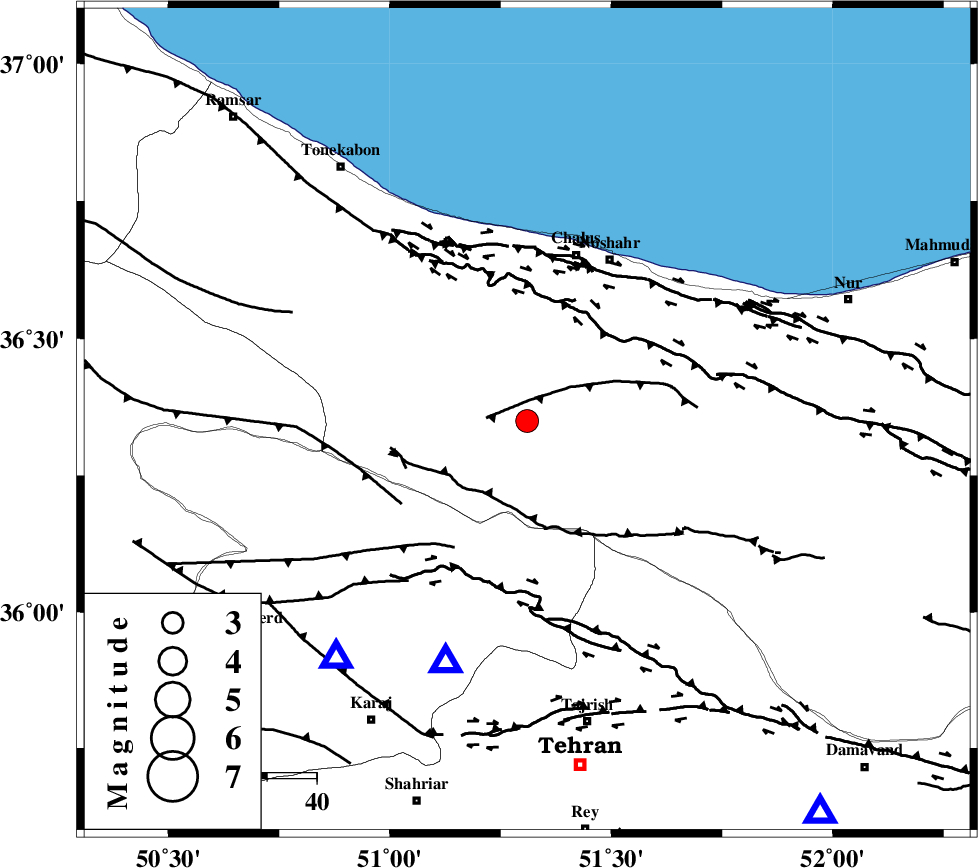
| Date & Time (UTC) | 2004-07-11 13:16:46.7 |
| Date & Time (Local) | 1383/4/21 17:46:46.7 |
| Location | Lat:36.35 Lon: 51.31 |
| Region | 35 km South-West of Chalus, Mazandaran Province |
Nearest Cities |
|
| 7 km of Tavir, Mazandaran Province | |
| 11 km of Marzanabad, Mazandaran Province | |
| 15 km North of Pol-e zanguleh, Mazandaran Province | |
| 16 km South of Goyter, Mazandaran Province | |
| 21 km South of Kardichal, Mazandaran Province | |
| Depth | 14 km |
| Agency | |
Faults within 150 km: |
|
| KOJOOR (Length: 75 km) , Distance to epicenter: 8 km | |
| KANDOVAN_F (Length: 90 km) , Distance to epicenter: 17 km | |
| N_ALBORZ_F (Length: 360 km) , Distance to epicenter: 25 km | |
| Number of Phases | 4 |
| RMS | 0.5 |
| Number of Stations | 3 |
| Error in Latitude | >24.4 km |
| Error in Longitude | 15 km |
| Error in Depth | 66.9 km |
Download waveform in seisan format
to download seisan software Click here
to access information about IIEES stations Click here
Amplitude | ||||||||
| UID | Agency | Station | Component | Amplitude | Period | Arrival Time | Proccessing Time | Signal Clip |
| 28095 | IIEES | DAMV | E | 649.5 | 0.13 | 2004-07-11 13:17:22 | 2006-03-15 11:56:00 | n |
| 28096 | IIEES | ASAO | N | 255.9 | 0.4 | 2004-07-11 13:17:55 | 2006-03-15 11:56:00 | n |
Phase | ||||||||||||
| Agency | Station | Component | Phase Type | Phase Quality | First Motion | Observed Arrival Time | Time Residual | Loc. Flag | Input Weight | Distance | Azimuth | |
| IIEES | DAMV | Z | PG | E | 2004-07-11 13:17:03 | 0.2 | y | 99.3 | 143 | |||
| IIEES | ASAO | Z | PG | E | 2004-07-11 13:17:23 | -0.8 | y | 231 | 211 | |||
| IIEES | ASAO | N | SG | E | 2004-07-11 13:17:52 | 0.4 | y | 231 | 211 | |||
| IIEES | MAKU | Z | PN | E | 2004-07-11 13:18:18 | 0.4 | y | 672 | 302 | |||