
Magnitude |
:2.4 |
| Date & Time (UTC) | 2004-07-07 09:15:16.5 |
| Date & Time (Local) | 1383/4/17 13:45:16.5 |
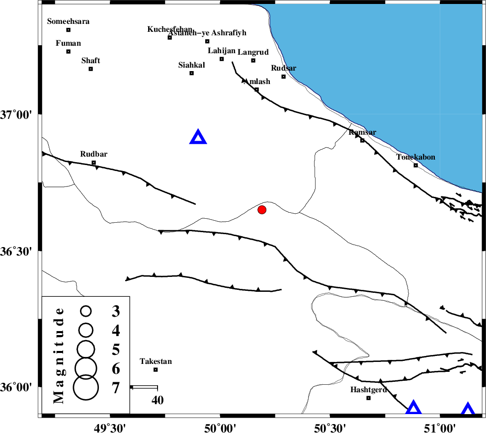
| Location | Lat:36.65 Lon: 50.19 |
| Region | 45 km North-East of Qazvin, Ghazvin Province |
Nearest Cities |
|
| 20 km East of Kelishom, Gilan Province | |
| 21 km North West of Tamol, Mazandaran Province | |
| 26 km South of Ziar, Gilan Province | |
| 26 km North of Rajaeedasht, Ghazvin Province | |
| 33 km North West of Moallemkelayeh, Ghazvin Province | |
| Depth | 14 km |
| Agency | |
Faults within 150 km: |
|
| BONAN_F (Length: 74 km) , Distance to epicenter: 12 km | |
| ALAMUTRUD_F (Length: 140 km) , Distance to epicenter: 13 km | |
| RUDBAR_F (Length: 93 km) , Distance to epicenter: 27 km | |
| Number of Phases | 6 |
| RMS | 0.3 |
| Number of Stations | 4 |
| Error in Latitude | >7.3 km |
| Error in Longitude | 6.1 km |
| Error in Depth | 11.9 km |
Download waveform in seisan format
to download seisan software Click here
to access information about IIEES stations Click here
Amplitude | ||||||||
| UID | Agency | Station | Component | Amplitude | Period | Arrival Time | Proccessing Time | Signal Clip |
| 28056 | IIEES | THKV | E | 129.3 | 0.51 | 2004-07-07 09:15:58 | 2006-03-15 11:56:00 | n |
| 28057 | IIEES | DAMV | N | 33.3 | 0.52 | 2004-07-07 09:16:19 | 2006-03-15 11:56:00 | n |
| 28058 | IIEES | ASAO | N | 36.3 | 0.75 | 2004-07-07 09:16:28 | 2006-03-15 11:56:00 | n |
Phase | ||||||||||||
| Agency | Station | Component | Phase Type | Phase Quality | First Motion | Observed Arrival Time | Time Residual | Loc. Flag | Input Weight | Distance | Azimuth | |
| IIEES | THKV | Z | PG | E | 2004-07-07 09:15:33 | -0.4 | y | 102 | 143 | |||
| IIEES | DAMV | Z | PG | E | 2004-07-07 09:15:49 | 0.4 | y | 196 | 125 | |||
| IIEES | DAMV | E | SG | E | 2004-07-07 09:16:12 | -0.1 | y | 196 | 125 | |||
| IIEES | ASAO | Z | PG | E | 2004-07-07 09:15:54 | -0.2 | y | 234 | 184 | |||
| IIEES | ASAO | N | SG | E | 2004-07-07 09:16:23 | 0.2 | y | 234 | 184 | |||
| IIEES | NASN | Z | PN | E | 2004-07-07 09:16:25 | 0.2 | y | 490 | 150 | |||