
Magnitude |
:2.4 |
| Date & Time (UTC) | 2004-09-03 11:37:20.0 |
| Date & Time (Local) | 1383/6/13 16:07:20.0 |
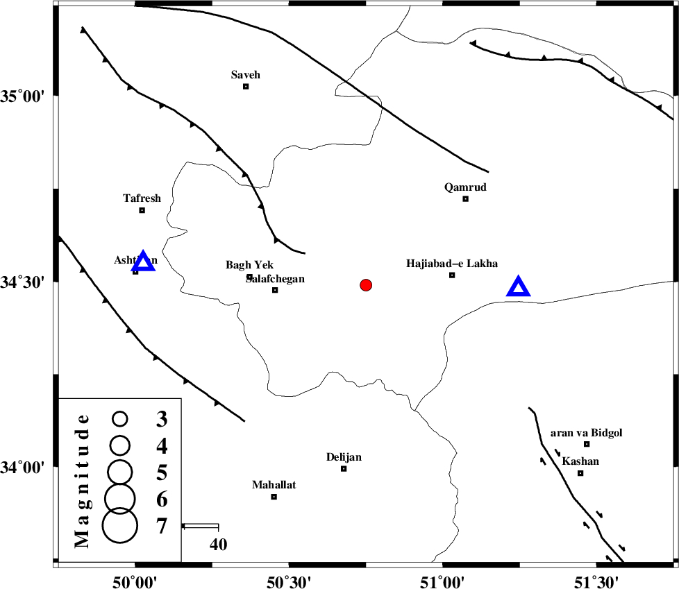
| Location | Lat:34.49 Lon: 50.75 |
| Region | 21 km South-West of Qom, Qom Province |
Nearest Cities |
|
| 17 km North West of Kahak, Qom Province | |
| 21 km South West of Qom, Qom Province | |
| 26 km West of Hajiabad-e lakha, Qom Province | |
| 27 km North East of Salafchegan, Qom Province | |
| 35 km East of Bagh yek, Qom Province | |
| Depth | 14 km |
| Agency | |
Faults within 150 km: |
|
| INDES_F (Length: 98 km) , Distance to epicenter: 20 km | |
| KUSHK_E_NOSRAT_F (Length: 230 km) , Distance to epicenter: 47 km | |
| TAFRESH_F (Length: 117 km) , Distance to epicenter: 55 km | |
| Number of Phases | 6 |
| RMS | 0.2 |
| Number of Stations | 4 |
| Error in Latitude | >9.7 km |
| Error in Longitude | 5.3 km |
| Error in Depth | 24.6 km |
Download waveform in seisan format
to download seisan software Click here
to access information about IIEES stations Click here
Amplitude | ||||||||
| UID | Agency | Station | Component | Amplitude | Period | Arrival Time | Proccessing Time | Signal Clip |
| 28030 | IIEES | THKV | N | 48.4 | 0.16 | 2004-09-03 11:38:10 | 2006-03-15 11:56:00 | n |
| 28031 | IIEES | THKV | E | 30.1 | 0.52 | 2004-09-03 11:38:14 | 2006-03-15 11:56:00 | n |
| 28032 | IIEES | DAMV | E | 79.2 | 0.24 | 2004-09-03 11:38:09 | 2006-03-15 11:56:00 | n |
| 28033 | IIEES | DAMV | N | 55.9 | 0.25 | 2004-09-03 11:38:10 | 2006-03-15 11:56:00 | n |
Phase | ||||||||||||
| Agency | Station | Component | Phase Type | Phase Quality | First Motion | Observed Arrival Time | Time Residual | Loc. Flag | Input Weight | Distance | Azimuth | |
| IIEES | ASAO | Z | PG | E | 2004-09-03 11:37:31 | -0.2 | y | 66.7 | 276 | |||
| IIEES | ASAO | N | SG | E | 2004-09-03 11:37:40 | 0.1 | y | 66.7 | 276 | |||
| IIEES | THKV | Z | PG | E | 2004-09-03 11:37:46 | 0.3 | y | 159 | 4 | |||
| IIEES | DAMV | Z | PG | E | 2004-09-03 11:37:47 | -0.2 | y | 169 | 41 | |||
| IIEES | DAMV | E | SG | E | 2004-09-03 11:38:08 | -0.1 | y | 169 | 41 | |||
| IIEES | NASN | Z | PN | E | 2004-09-03 11:38:01 | 0.1 | y | 268 | 134 | |||